1831 - Lewis, Samuel - Topographical Dictionary of England (14)
From International Robin Hood Bibliography
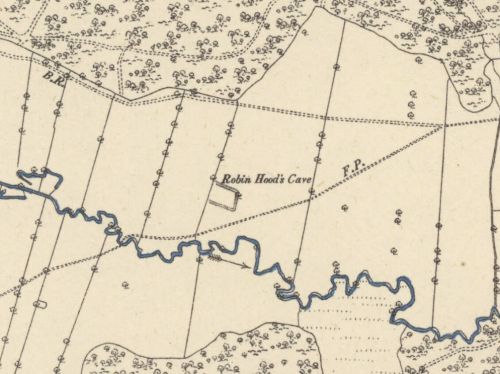
The site of Robin Hood's Cave, now at the bottom of the Rutland Water reservoir.

Robin Hood's Cave indicated on 6" O.S. map Rutland IX.NE (18895; surveyed 1884) / National Library of Scotland.
By Henrik Thiil Nielsen, 2017-05-26. Revised by Henrik Thiil Nielsen, 2018-10-18.
Allusion
WHITWELL, a parish in the hundred of Alstoe, county of Rutland, 4½ miles (E.) from Oakham, containing 112 inhabitants. The living is a rectory, in the archdeaconry of Northampton, and diocese of Peterborough, rated in the king’s books at £5, and in the patronage of Sir G. Noel Noel, Bart. The church is dedicated to St. Michael. A small mound in the neighbourhood, bearing the name of Robin Hood’s Cave, is supposed to have been a retreat of that celebrated outlaw.[1]
Source notes
Capitals and small caps as in printed source.
IRHB comments
This is the earliest mention of Robin Hood's Cave in Whitwell, Rutland, found so far
Lists
- Not included in Dobson, R. B., ed.; Taylor, J., ed. Rymes of Robyn Hood: an Introduction to the English Outlaw (London, 1976), pp. 315-19.
- Outside scope of Sussex, Lucy, compil. 'References to Robin Hood up to 1600', in: Knight, Stephen. Robin Hood: A Complete Study of the English Outlaw (Oxford, UK; Cambridge, Massachusetts: Blackwell, 1994), pp. 262-88.
Editions
- Lewis, Samuel, compil. A Topographical Dictionary of England, comprising the Several Counties, Cities, Boroughs, Corporate and Market Towns, Parishes, Chapelries, and Townships, and the Islands of Guernsey, Jersey, and Man, with Historical and Statistical Descriptions (London, 1831); see vol. IV, p. 463, s.n. Whitwell [3]
- Lewis, Samuel, compil. A Topographical Dictionary of England, comprising the Several Counties, Cities, Boroughs, Corporate and Market Towns, Parishes, Chapelries, and Townships, and the Islands of Guernsey, Jersey, and Man, with Historical and Statistical Descriptions. Second Edition (London, 1833); see vol. IV (unpag.), s.n. Whitwell [2]
- Lewis, Samuel, compil. A Topographical Dictionary of England, comprising the Several Counties, Cities, Boroughs, Corporate and Market Towns, Parishes, Chapelries, and Townships, and the Islands of Guernsey, Jersey, and Man, with Historical and Statistical Descriptions. Third Edition (London, 1835); see vol. IV (unpag.), s.n. Whitwell [3]; omits mention of Robin Hood's Cave
- Lewis, Samuel, compil. A Topographical Dictionary of England, comprising the Several Counties, Cities, Boroughs, Corporate and Market Towns, Parishes, Chapelries, and Townships, and the Islands of Guernsey, Jersey, and Man, with Historical and Statistical Descriptions. Fourth Edition (London, 1840); see vol. IV, pp. 498, s.n. Whitwell [2]; omits mention of Robin Hood's Cave
- Lewis, Samuel, compil. A Topographical Dictionary of England, comprising the Several Counties, Cities, Boroughs, Corporate and Market Towns, Parishes, Chapelries, and Townships, and the Islands of Guernsey, Jersey, and Man, with Historical and Statistical Descriptions. Fifth Edition (London, 1845); see vol. IV, pp. 550, s.n. Whitwell [3]; omits mention of Robin Hood's Cave
- Lewis, Samuel, compil. A Topographical Dictionary of England, comprising the Several Counties, Cities, Boroughs, Corporate and Market Towns, Parishes, Chapelries, and Townships, and the Islands of Guernsey, Jersey, and Man, with Historical and Statistical Descriptions. Seventh Edition (London, 1848); see vol. IV, pp. 561, s.n. Whitwell [3]; omits mention of Robin Hood's Cave.
Background
Notes
- ↑ Lewis, Samuel, compil. A Topographical Dictionary of England, comprising the Several Counties, Cities, Boroughs, Corporate and Market Towns, Parishes, Chapelries, and Townships, and the Islands of Guernsey, Jersey, and Man, with Historical and Statistical Descriptions (London, 1831), vol. IV, p. 463, s.n. Whitwell [3].
