Robinhood Field (Ripon)
| Locality | |
|---|---|
| Coordinate | 54.130736, -1.534201 |
| Adm. div. | West Riding of Yorkshire |
| Vicinity | NW area of Borrage Green, S of River Skell in Ripon |
| Type | Area |
| Interest | Robin Hood name |
| Status | Defunct? |
| First Record | 1838 |
By Henrik Thiil Nielsen, 2013-09-06. Revised by Henrik Thiil Nielsen, 2022-04-22.
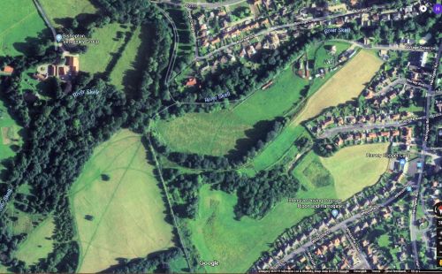
'Robinhood Field' was (or is?) the name of the north-western part of Borrage Green, south of the Skell in Ripon. The name is first recorded in 1838.
The tithe award for Ripon (1838) lists two adjacent pieces of grassland under this name, one with an area of 1 acre, 3 roods and 36 perches (7992.54 m2), the other 1 acre, 3 roods and 16 perches (7486.68 m2). The owner was an Elizabeth Sophia Lawrence, the occupiers John Lowley, respectively Christopher Nelson.[1] The boundary between the two pieces of grassland roughly coincides with what looks like a path running NE to SW across the area on the Google satellite image (see below).
Could this be a relatively old field name despite being first recorded in 1840? The spelling "Robinhood" is not very common for a modern Robin Hood place-name, but it is of course possible that the field was named after an owner surnamed Robinhood. Robinhood Field is located c. 4 km NE of Fountains Abbey, which in additions to the traditions connecting it with the Curtal Friar/Friar Tuck has a Robin Hood's Park and Well. Ripon is now administratively part of North Yorkshire.
The trees lining Robinhood Field on the west and south-west, and a few other stands of trees beyond them, were known collectively as Robin Hood Wood in the mid-19th century.
Gazetteers
- Not included in Dobson, R. B., ed.; Taylor, J., ed. Rymes of Robyn Hood: an Introduction to the English Outlaw (London, 1976), pp. 293-311.
MS sources
- Ripon tithe award, plot Nos. 268 and 271 (The Genealogist: Piece 43, sub-piece 335, Image 323) (£). 1838
- Ripon tithe map (The Genealogist: Piece 43, sub-piece 335, Sub-Image 001) (£). 1838
Printed sources
- Smith, A.H. The Place-Names of the West Riding of Yorkshire (English Place-Name Society, vols. XXX-XXXVII) (Cambridge, 1961-63), pt. V, pp. 171-72.
Maps
- 6" O.S. map Yorkshire 119 (1856; surveyed 1849-53)
- 6" O.S. map Yorkshire CXIX.NW (1910; rev. 1907-1908) (georeferenced)
- 6" O.S. map Yorkshire CXIX.NW (1910; rev. 1907-1908)
- 6" O.S. map Yorkshire CXIX.NW (1930; rev. 1928)
- 6" O.S. map Yorkshire CXIX.NW (1947; rev. 1938)
- 25" O.S. map Yorkshire CXIX.6 (1892; surveyed 1890-91)
- 25" O.S. map Yorkshire CXIX.6 (1909; rev. 1908) (georeferenced)
- 25" O.S. map Yorkshire CXIX.6 (1909; rev. 1908)
- 25" O.S. map Yorkshire CXIX.6 (1929; rev. 1928).
Also see
Notes
- ↑ Ripon tithe award (1838), plot Nos. 268 and 271 (The Genealogist: Piece 43, sub-piece 335, Image 323) (£); Ripon Tithe map (1838) (The Genealogist: Piece 43, sub-piece 335, Sub-Image 001) (£); Smith, A.H. The Place-Names of the West Riding of Yorkshire (English Place-Name Society, vols. XXX-XXXVII) (Cambridge, 1961-63), pt. V, pp. 171-72, dates the tithe award 1840.

