
Robin Hood Plantations (Baslow) (2)
| Locality | |
|---|---|
| Coordinate | 53.240862, -1.588426 |
| Adm. div. | Derbyshire |
| Vicinity | c. 380 m S of A219 in Robin Hood, Baslow; near the Emperor Stream |
| Type | Area |
| Interest | Robin Hood name |
| Status | Extant |
| First Record | 1922 |
| A.k.a. | Robin Hood Plantation |

By Henrik Thiil Nielsen, 2021-012-08. Revised by Henrik Thiil Nielsen, 2021-02-13.
The Robin Hood Plantations in the hamlet of Robin Hood, Baslow, were known under that name by 1922.
They are named on a 25" O.S. map of the area published in 1922, based on a revision carried out in 1919, and on a 6" O.S. map published 1923, based on a revision prepared 1919–20. They are included, but not named, on earlier and later O.S. maps of the area, the earliest dating from 1883. The southernmost of the two plantations is situated 'c. 380 metres south of the A219, near the Emperor Stream. A fairly recent blog post mentioning 'Robin Hood Plantation' suggests that the name is still current.[1]
Gazetteers
- Dobson, R. B., ed.; Taylor, J., ed. Rymes of Robyn Hood: an Introduction to the English Outlaw (London, 1976), pp. 296, s.n. "Robin Hood".
Sources
Maps
Maps of the area.
- 25" O.S. map Derbyshire XXIV.2 (c. 1879; surveyed c. 1878). No copy in NLS
- 25" O.S. map Derbyshire XXIV.2 (1898; rev. 1897)
- 25" O.S. map Derbyshire XXIV.2 (1922; rev. 1919).
- 25" O.S. map of Baslow And Bubnell parish, Derbyshire (1950s) (georeferenced)
- 6" O.S. map Derbyshire Sheet XXIV.NW (1883; surveyed 1876–78)
- 6" O.S. map Derbyshire XXIV.NW (1899; rev. 1897) (georeferenced)
- 6" O.S. map Derbyshire Sheet XXIV.NW (1899; rev. 1897)
- 6" O.S. map Derbyshire XXIV (1923; rev. 1919–20)
- 6" O.S. map Derbyshire Sheet XXIV.NW (1923; rev. 1919–20).
Also see
Notes
Image gallery
Click any image to display it in the lightbox, where you can navigate between images by clicking in the right or left side of the current image.
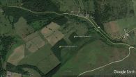
The northernmost of the Robin Hood Plantations / Google Earth Street View (click or tap to enlarge).