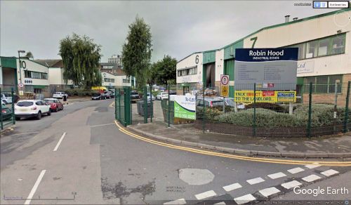
Robin Hood Industrial Estate (Nottingham)
From International Robin Hood Bibliography
| Locality | |
|---|---|
| Coordinate | 52.956936, -1.136559 |
| Adm. div. | Nottinghamshire |
| Vicinity | On E side of Robin Hood Street; access from ALfred Street South |
| Type | Area |
| Interest | Robin Hood name |
| Status | Extant |
| First Record | |
Robin Hood Industrial Estate.
By Henrik Thiil Nielsen, 2018-05-05. Revised by Henrik Thiil Nielsen, 2021-01-07.
Robin Hood Industrial Estate is situated on the east side of Robin Hood Street in Nottingham. Access only from Alfred Street South. It is located in a neighbourhood with a couple of other Robin Hood-related place-names. See Victoria Park (Nottingham) place-name cluster. Robin Hood Industrial Estate is not labelled on any of the maps listed below, and therefore is hardly older than the mid-20th century. It does not look recent enough to be of 21st century date.
Gazetteers
- Not included in Dobson, R. B., ed.; Taylor, J., ed. Rymes of Robyn Hood: an Introduction to the English Outlaw (London, 1976), pp. 293-311.
Maps
- 25" O.S. map Nottinghamshire XLII.2 (1881; surveyed 1881)
- 25" O.S. map Nottinghamshire XLII.2 (1901; rev. 1899)
- 25" O.S. map Nottinghamshire XLII.2 (1901; rev. 1899) (georeferenced)
- 25" O.S. map Nottinghamshire XLII.2 (1915; rev. 1913)
- 6" O.S. map Nottinghamshire XLII.NW (1885; surveyed 1880-81)
- 6" O.S. map Nottinghamshire XLII.NW (1901; rev. 1899)
- 6" O.S. map Nottinghamshire XLII.NW (1901; rev. 1899) (georeferenced)
- 6" O.S. map Nottinghamshire XLII.NW (1920; rev. 1919)
- 6" O.S. map Nottinghamshire XLII.NW (c. 1947; rev. 1918).
Also see

