Robin Hood (Langwathby)
| Locality | |
|---|---|
| Coordinate | 54.703733, -2.65794 |
| Adm. div. | Cumberland |
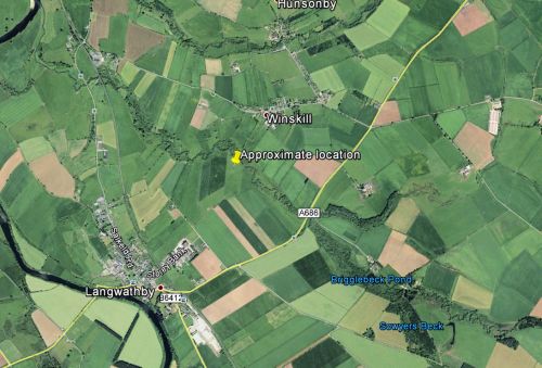
| Vicinity | Between Langwathby and Winskill, slightly SE of Brigglebeck |
| Type | Prehistoric site |
| Interest | Robin Hood name |
| Status | Extant |
| First Record | 1989 |
By Henrik Thiil Nielsen, 2017-08-28. Revised by Henrik Thiil Nielsen, 2021-01-07.
'Robin Hood' is the local name for a small unlisted but possibly pre-historic monument, located somewhere in an enclosure east of the public footpath from Langwathby to Winskill and south of Brigglebeck. The monument, a cist oriented east–west, with its large capstone now lying on the ground a little to the west, sits on top of a low rise, which may well be of natural origin. The cist is about 1.2 m in length, c. 0.5 m in width, and its height above ground some 20 to 35 cm, all four sides being made up of single blocks. It is filled with smaller stones. The slightly oblong capstone (also red sandstone) is c. 1.5 m in length and between c. 90 cm and c. 1.14 m in width. The monument, perhaps mainly because it sits on slightly elevated ground, is visible from the footpath.[1]
As is so often the case with Robin Hood place-names, it is not known why this rather modest monument has come to be named after the outlaw, but a Langwathby man stated – possibly in 1989, certainly no later than 1996 – that it is known locally as "Robin Hood" and "is the site of an ancient battle"; "under this mound, they say, 'are buried the slain'".[1]
Gazetteers
- Not included in Dobson, R. B., ed.; Taylor, J., ed. Rymes of Robyn Hood: an Introduction to the English Outlaw (London, 1976), pp. 293-311.
Sources
Maps
The monument is not indicated or labelled.
- 6" O.S. map Cumberland L (1867; surveyed 1867)
- 6" O.S. map Cumberland L.SE (1900; rev. 1898)
- 6" O.S. map Cumberland L.NE (1900; rev. 1898)
- 6" O.S. map Cumberland L.SE (1900; rev. 1898) (georeferenced)
- 6" O.S. map Cumberland L.NE (1927; rev. 1923)
- 6" O.S. map Cumberland L.SE (1927; rev. 1923)
Background
Notes

