
Robin Hood (Anerley)
| Locality | |
|---|---|
| Coordinate | 51.408748, -0.059251 |
| Adm. div. | Surrey, now Greater London |
| Vicinity | Intersection of Croydon and Elmer's End roads, 1897 |
| Type | Public house |
| Interest | Robin Hood name |
| Status | Defunct |
| First Record | 1861 |
| A.k.a. | Robin Hood hotel; Robin Hood Tavern |

By Henrik Thiil Nielsen, 2020-05-18. Revised by Henrik Thiil Nielsen, 2021-02-13.
The Robin Hood on the corner of Croydon and Elmer's End roads in Anerley is first recorded in 1861. It closed c. 2005. There is now an Aldi at the site.
Pub Wiki lists information on publicans and residents for the years 1861-1922. The address of the pub has been variously given as Oak Grove (1867) and 101 Croydon Road. In 1874 it is referred to as 'the Robin Hood Tavern',[1] in 1896 it is listed as 'Robin Hood hotel'.[2] The pub is included (without name) on the early 25" O.S. maps listed below. Now Greater London, historically the area belonged to Surrey. It was very close to the Kent/Surrey county boundary.
Gazetteers
- Not included in Dobson, R. B., ed.; Taylor, J., ed. Rymes of Robyn Hood: an Introduction to the English Outlaw (London, 1976), pp. 293-311.
Sources
- Facebook: Bromley Gloss - London Borough of Bromley - Current, Upcoming, Historic
- London Pubology: Robin Hood
- Penge section of an 1876 directory, p. 12; also see advertisement for T. Candy, Monumental Sculptor
- Pub Wiki: Robin Hood, 101 Croydon Road, Anerley.[3]
Maps
- 25" O.S. map Kent VII.14 (c. 1866; surveyed 1861). No copy in NLS
- 25" O.S. map Kent VII.14 (c. 1897; rev. c. 1894-95). No copy in NLS
- 25" O.S. map Kent VII.14 (1912, rev. 1910) (georeferenced)
- 25" O.S. map Kent VII.14 (1912; rev. 1910)
- 25" O.S. map Kent VII.14 (1933; rev. 1929-1930)
- 6" O.S. map Surrey VIII.SE (1898, rev. 1893 to 1895) (georeferenced)
- 6" O.S. map Kent VII (1870; surveyed 1863)
- 6" O.S. map Surrey VIII (1874; surveyed 1870)
- 6" O.S. map London XV.NE (1894-1896; rev. 1894)
- 6" O.S. map Surrey VIII.SE (1898; rev. 1893-1895)
- 6" O.S. map Kent VII.SW (1898; rev. 1894-1895)
- 6" O.S. map Kent VII.SW (1915; rev. 1910)
- 6" O.S. map London Sheet S (1919; rev. 1913-1914)
- 6" O.S. map Kent VII.SW (c. 1934; rev. 1929-1930)
- 6" O.S. map Kent VII.SW (c. 1946; rev. 1938)
- 6" O.S. map London Sheet S (c. 1946; rev. 1938).
Background
Also see
Notes
- ↑ Advertisement for T. Candy, Monumental Sculptor, in an 1876 directory which includes the hamlet of Penge.
- ↑ Pub Wiki: Robin Hood, 101 Croydon Road, Anerley; London 1874 Licensed Victuallers and Hotel Keepers Directory - London South R; London (South) 1896 Suburban Publicans directory listing - R. Also see Penge section of an 1876 directory, p. 12; also see London Pubology: Robin Hood.
- ↑ Also see there: London 1874 Licensed Victuallers and Hotel Keepers Directory - London South R; London (South) 1896 Suburban Publicans directory listing - R.
Image gallery
Click any image to display it in the lightbox, where you can navigate between images by clicking in the right or left side of the current image.
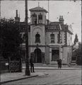
The Robin Hood pub, probably in the 1920s / Facebook: Bromley Gloss - London Borough of Bromley - Current, Upcoming, Historic (posted 2018-09-29).

The site of the Robin Hood / Google Earth Street View.
