
Robin Hood's Butts (Weaverham) (4)
| Locality | |
|---|---|
| Coordinate | 53.25371, -2.57553 |
| Adm. div. | Cheshire |
| Vicinity | c. 700 m E of Gorstage Lane; immediately N of tracks of London Northwestern Railway; c. 350 m S of Walnut Avenue; in Weaverham |
| Type | Area |
| Interest | Robin Hood name |
| Status | Defunct |
| First Record | 1839 |
| A.k.a. | Robin Hoods Butts |

By Henrik Thiil Nielsen, 2017-01-22. Revised by Henrik Thiil Nielsen, 2022-05-08.
Two plots of land just south of Weaverham were known as Robin Hood's Butts in 1839.
This entry is concerned with the southernmost of the two butts, which figure in the 1839 tithe award for Weaverham. The butt had an area of 2 acres, 2 roods and 16 perches (10521.83 m2). The landowner is listed as William Colley Woodfine, the occupier was a Peter Hatton. The tithe award omits the ususally provided information about the state of cultivation of the plot.[1]
The name 'Robin Hood's Butts' is often applied to pairs of mounds or hillocks (see Places named Robin Hood's Butts), but the term 'butt' can also refer to a 'raised strip of cultivated land between two furrows, a ridge' or a 'small piece of land, esp. of an irregular shape; a paddock'.[2] It is not clear if the name was applied to mounds or hillocks within these plots or if it referred to the shapes of the plots. The northernmost of the two butts was situated c. 100 m south of Walnut Avenue, its centrepoint being about 75 m north of that of its southern counterpart. One of the English Place-Name Society's volumes on Cheshire notes – presumably these – Robin Hoods Butts but mistakenly puts them in Cuddington,[3] a village situated about 2 km SSW of Weaverham. The two butts can be seen in the detail of the tithe map included in the image gallery below. The southernmost butt is No. 335, near the centre of the map detail. Above it is No. 343, northwest of which is No. 328, northwest of which is No. 329, the northernmost Robin Hood's Butts. About 1.75 km north-northwest of the northernmost of these butts is the northernmost of another pair of former Robin Hood's Butts.
Gazetteers
- Not included in Dobson, R. B., ed.; Taylor, J., ed. Rymes of Robyn Hood: an Introduction to the English Outlaw (London, 1976), pp. 293-311.
MS sources
- Tithe award for Weaverham (1839) (Piece 05, Sub-Piece 416, Image 056, #335 – at The Genealogist) (£)
- Tithe map for Weaverham (1831) (Piece 05, Sub-Piece 416, Sub-Image 001, #335 – at The Genealogist) (£).
Printed sources
Maps
- 6" O.S. map Cheshire XXXIII (1882; surveyed 1873–77)
- 6" O.S. map Cheshire XXXIII.SE (1899; rev. 1897) (georeferenced)
- 6" O.S. map Cheshire XXXIII.SE (1899; rev. 1897)
- 6" O.S. map Cheshire XXXIII.SE (1911; rev. 1908–09)
- 6" O.S. map Cheshire XXXIII.SE (c. 1947; rev. 1938)
- 25" O.S. map Cheshire XXXIII.12 (c. 1874; surveyed c. 1871–72). No copy in NLS
- 25" O.S. map Cheshire XXXIII.12 (1898; rev. 1897) (georeferenced)
- 25" O.S. map Cheshire XXXIII.12 (1898; rev. 1897)
- 25" O.S. map Cheshire XXXIII.12 (1910; rev. 1908).
Background
- OED, butt, n.2, 1. a. and 2 (£).
- Wikipedia: Cuddington, Eddisbury
- Wikipedia: Weaverham.
Also see
Notes
- ↑ Tithe award for Weaverham (1839) (Piece 05, Sub-Piece 416, Image 057, #327 – at The Genealogist) (£); Tithe map for Weaverham (1831) (Piece 05, Sub-Piece 416, Image 056, #335 – at The Genealogist) (£).
- ↑ OED, butt, n.2, 1. a. and 2 (£).
- ↑ Dodgson, John McN.; Rumble, Alexander R. The Place-Names of Cheshire, pts. I-V (English Place-Name Society, vols. XLIV-XLVIII, LIV, LXXIV) (Cambridge, 1970-72; [s.l.], 1981; Nottingham, 1997), vol. III, p.200.
Image gallery
Click any image to display it in the lightbox, where you can navigate between images by clicking in the right or left side of the current image.
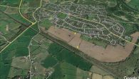
The centrepoints of the two areas known as Robin Hood's Butts / Google Earth Street View.
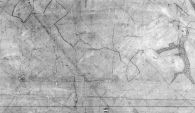
The two plots numbered 327 and 335, near the centre, were known as Robin Hood's Butts. Detail of MS tithe map / © Crown Copyright Images reproduced by courtesy of The National Archives, London, England. www.NationalArchives.gov.uk & www.TheGenealogist.co.uk.
