
Robin Hood's Butts (Canon Pyon) (2)
| Locality | |
|---|---|
| Coordinate | 52.137295, -2.820943 |
| Adm. div. | Herefordshire |
| Vicinity | In Canon Pyon, c. 2.1 km W of the A4110 |
| Type | Natural feature |
| Interest | Robin Hood name |
| Status | Extant |
| First Record | 1802 |
| A.k.a. | Butthouse Knap; the Pyons |

By Henrik Thiil Nielsen, 2018-02-12. Revised by Henrik Thiil Nielsen, 2022-02-17.
'Robin Hood's Butts' is the collective name of Pyon Hill and Butthouse Knap, two natural hills[1] in Canon Pyon, Herefordshire. This place-name is first recorded in 1802.
See further Robin Hood's Butts (Canon Pyon) (1).
Allusions
1802 - Lipscomb, George - Journey into South Wales
We made an excursion to visit Weobley encampment; and an unusually fine morning gave us an opportunity of seeing it to great advantage.
It is placed on the summit of a proud eminence, which overtops the neighbouring country, and frowns defiance at the huge ridges, which every where raise themselves around it.
Even if the antiquity of this camp did not recommend it to the notice of the curious, the delightful prospect which it commands would render it an object well worthy of attention to the
contemplative traveller.
To the south-east, the eye stretches as far as May Hill, in Gloucestershire: and the city of Hereford is only hidden by the intervention of a range of hills, which terminates in the remarkable promontory of Lady-lift before mentioned. Skerrit, in Monmouthshire, and the Black Mountains, whose summits were wrapped in snow, enclose the prospect on the south; and the Radnorshire hills, in a vast variety of shapes, on the west and north-west, are objects highly striking and picturesque. [p. 98:]
Robin Hood's Butts, a little detached eminence, stands in the midst of a beautiful plain, called Pembridge bottom. The Earl of Oxford's seat, at Eywood, is seen in the valley below, sheltered and embosomed among rich woods and plantations; and on the north, the town of Presteign, with the villas at Broad-heath and Stapleton, seems lying at the foot of this stupendous height.[2]
2001 - Rickman, Phil - The Cure of Souls (1)
Allan Henry's sitting room had one wall that was all plate glass, perhaps forty feet long. It had wide green views across to one of the conical, wooded humps known as Robin Hood's Butts. Appropriately, according to legend, the Butts had been dumped there by the Devil, making him Hereford's first sporadic developer.[3]
2001 - Rickman, Phil - The Cure of Souls (2)
'Mr Henry, all I'm concerned about – ' she wished she was the other side of the plate glass; she would run and run, all the way to Robin Hood's Butts ' – is kids dabbling with the dead. That kind of worries me. I can't stop them. All I can do is advise them that they could be messing with something that can't easily be controlled.'[4]
Gazetteers
- Dobson, R. B., ed.; Taylor, J., ed. Rymes of Robyn Hood: an Introduction to the English Outlaw (London, 1976), p. 298, s.n. Robin Hoods' Butts.
Sources
- Crawford, O. G. S. 'Place-Names and Archaeology', chapter VIII in: Mawer, A.; Stenton, F.M. Introduction to the Survey of English Place-Names (English Place-Name Society, vol. I, pt. 1). (Cambridge, 1924), pp. 143-64; see p. 159
- Smith, A.H. English Place-Name Elements. Reprinted (English Place-Name Society, vols. XXV-XXVI) (Cambridge, 1970), pt. I, p. 165 s.n. butt2, b.
Maps
- 25" O.S. map Herefordshire XXVI.1 (1887; rev. 1886)
- 25" O.S. map Herefordshire XXVI.5 (1904; rev. 1902)
- 25" O.S. map Herefordshire XXVI.5 (1904; rev. 1902) (georeferenced)
- 6" O.S. map Herefordshire XXVI.NW 1886; surveyed 1886)
- 6" O.S. map Herefordshire XXVI.NW (1905; rev. 1902)
- 6" O.S. map Herefordshire XXVI.NW (1905; rev. 1902) (georeferenced)
- 6" O.S. map Herefordshire XXVI.NW (1952; rev. 1945)
- 1" O.S. map Hereford (Hills), Sheet 128 (1898; rev. 1897) (georeferenced)
- 1" O.S. map Hereford (Outline), Sheet 128 (1898; rev. 1897) (georeferenced)
- O.S. 1:25,000 SO44 (1956; surveyed 1945) (georeferenced)
- O.S. 1" Hereford (7th Ser.) (1960; surveyed 1944-60) (georeferenced)
- 1:1 million-1:10K O.S. SO 454495 (1900s) (georeferenced)
- 1:1m to 1:63K (1920s–1940s) SO454495 (georeferenced)
- Bartholomew 1/2" Hereford Sheet 23 (1902) (georeferenced)
- Bartholomew 1/2" Wye Valley Sheet 13 (1944) (georeferenced).
Discussion
- BBC: Domesday Reloaded: D-block GB-344000-249000: 1986, Folk Lore,Canon Pyon Area
- Leather, Ella Mary. 'Folk-Lore of the Shire', in: Reade, Compton, ed. Memorials of Old Herefordshire (London and Derby, 1904), pp. 148-66; see p. 163
- Leather, Ella Mary. The Folk-Lore of Herefordshire, collected from Oral and Printed Sources (Hereford; London, 1912), p. ?
- [Nicholson, George, ed.]. The Cambrian Traveller's Guide, in Every Direction; containing Remarks made during Many Excursions, in the Principality of Wales, and Bordering Districts, augmented by Extracts from the Best Writers. Second edition, corrected and considerably enlarged (Stourport and London, 1813), col. 1116. A slightly expanded paraphrase of the 1802 Allusion cited above
- Symonds, W.S. 'The Old Red Sandstone of Herefordshire', in: Moore, H. Cecil, compil. Transactions of the Woolhope Naturalists' Field Club. (Established 1851), 1852 to 1865 (Hereford, 1907), pp. 114-19; see p. 115
- Watkins, Alfred. The Old Straight Track: its Mounds, Beacons, Moats, Sites, and Mark Stones. 4th ed. (London, 1948), p. 171 (also editions of 1925, 1933, 1946, 1970, 1974, 1975, 1977, and 2014).
Background
Also see
Notes
- ↑ Crawford, O. G. S. 'Place-Names and Archaeology', chapter VIII in: Mawer, A.; Stenton, F.M. Introduction to the Survey of English Place-Names (English Place-Name Society, vol. I, pt. 1). (Cambridge, 1924), pp. 143-64; see p. 159.
- ↑ Lipscomb, George. Journey into South Wales, through the Counties of Oxford, Warwick, Worcester, Hereford, Salop, Stafford, Buckingham, and Hertford; in the Year 1799 (London, 1802), pp. 97-98.
- ↑ Rickman, Phil. The Cure of Souls (London; Basingstoke; Oxford. 2002), p. 385.
- ↑ Rickman, Phil. The Cure of Souls (London; Basingstoke; Oxford. 2002), p. 391.
Image gallery
Click any image to display it in the lightbox, where you can navigate between images by clicking in the right or left side of the current image.
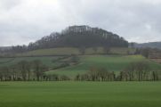
Butthouse Knap, the westernmost of the Robin Hood's Butts in Canon Pyon / 31 Mar 2006, Creative Commons.
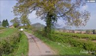
Butthouse Knap from the southwest / Google Earth Street View.

Butthouse Knap from the east / Google Earth Street View.

