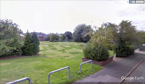
Lower Robin Hood Field (Helsby)
| Locality | |
|---|---|
| Coordinate | 53.270635, -2.771821 |
| Adm. div. | Cheshire |
| Vicinity | Western corner of Chester Road and Lower Robin Hood Lane, Helsby |
| Type | Area |
| Interest | Robin Hood name |
| Status | Defunct |
| First Record | 1844 |
By Henrik Thiil Nielsen, 2019-06-04. Revised by Henrik Thiil Nielsen, 2022-04-22.
Lower Robin Hood Field in Helsby is first recorded in 1844. It was named after the Robin Hood pub which was until recently located on the north-eastern corner of Chester Road and Lower Robin Hood Lane. Lower Robin Hood Field lay along the latter lane, opposite Robin Hood Field.
Lower Robin Hood Field is listed in the 1844 tithe award for Helsby with a William Forshaw as owner, John Lewis as occupier, state of cultivation as 'Pasture', and an area of 10 acres, 1 rood and 9 perches (41707.91 m2).[1] It occupied the area from Chester Road in the east and more or less to the end of Lower Robin Hood Lane in the west, stretching about as far south as the two southern side streets of the lane.
Gazetteers
- Not included in Dobson, R. B., ed.; Taylor, J., ed. Rymes of Robyn Hood: an Introduction to the English Outlaw (London, 1976), pp. 293-311.
MS sources
- 1844 Tithe award for Helsby, online at the Genealogist, Piece 05, sub-piece 199, Image 013, item 138 (£)
- Accompanying map, online at the Genealogist, Piece 05, sub-piece 199, Sub-Image 001, item 138 (£).
Maps
- 25" O.S. map Cheshire XXXII.6 (c. 1874; surveyed c. 1872). No copy in NLS
- 25" O.S. map Cheshire XXXII.6 (1898; rev. 1897) (georeferenced)
- 25" O.S. map Cheshire XXXII.6 (1898; rev. 1897)
- 25" O.S. map Cheshire XXXII.6 (1935; rev. 1908)
- 6" O.S. map Cheshire XXXII (1881; surveyed 1873-74)
- 6" O.S. map Cheshire XXXII.NW (1899; rev. 1897) (georeferenced)
- 6" O.S. map Cheshire XXXII.NW (1899; rev. 1897)
- 6" O.S. map Cheshire XXXII.NW (1911; rev. 1908)
- 6" O.S. map Cheshire XXXII.NW (c. 1936; rev. 1908)
- 6" O.S. map Cheshire XXXII.NW (c. 1944; rev. 1938).
Also see
Notes
- ↑ Online at the Genealogist, Piece 05, sub-piece 199, Image 013, item 138 (£).

