
Robin Hood and Little John (Tonwell): Difference between revisions
(Created page with "__NOTOC__{{PnItemTop|Lat=51.837451|Lon=-0.065235|AdmDiv=Hertfordshire|Vicinity=On Ware Road, Tonwell, Ware|Type=Public house|Interest=Robin Hood name| Status=Extant|Demonym=|R...") |
m (Text replacement - "ImgGalleryIntro" to "ImageGalleryIntroduction") |
||
| (12 intermediate revisions by the same user not shown) | |||
| Line 1: | Line 1: | ||
__NOTOC__{{ | __NOTOC__{{PlaceNamesItemTop|Lat=51.837451|Lon=-0.065235|AdministrativeDivision=Hertfordshire|Vicinity=On Ware Road, Tonwell, Ware|Type=Public house|Interest=Robin Hood name| | ||
Status=Extant|Demonym=|Riding=|GreaterLondon=|Year=1851|Aka=|Century=|Cluster1=|Cluster2=|Cluster3=|Image=geograph-3767110-by-Bikeboy.jpg|Postcards=|ExtraCat1=|ExtraCat2=|ExtraCat3=|ExtraCat4=|ExtraCat5=|ExtraLink1=|ExtraLink2=|ExtraLink3=|ExtraLink4=|ExtraLink5=|ExtraLinkName1=|ExtraLinkName2=|ExtraLinkName3=|ExtraLinkName4=|ExtraLinkName5=|GeopointPrefix=|GeopointSuffix=|VicinitySuffix=|StatusSuffix=|DatePrefix=|DateSuffix=}} | Status=Extant|Demonym=|Riding=|GreaterLondon=|Year=1851|Aka=Robin Hood & Little John; Little John; Robin Hood|Century=|Cluster1=|Cluster2=|Cluster3=|Image=geograph-3767110-by-Bikeboy.jpg|Postcards=|ExtraCat1=|ExtraCat2=|ExtraCat3=|ExtraCat4=|ExtraCat5=|ExtraLink1=|ExtraLink2=|ExtraLink3=|ExtraLink4=|ExtraLink5=|ExtraLinkName1=|ExtraLinkName2=|ExtraLinkName3=|ExtraLinkName4=|ExtraLinkName5=|GeopointPrefix=|GeopointSuffix=|VicinitySuffix=|StatusSuffix=|DatePrefix=|DateSuffix=}} | ||
{{#display_map:{{#var:Coords}}~{{#replace:{{PAGENAME}}|'|'}}|width=34%}}<div class="pnMapLegend">The Robin Hood & Little John.</div> | {{#display_map:{{#var:Coords}}~{{#replace:{{PAGENAME}}|'|'}}|width=34%|fullscreen=yes}}<div class="pnMapLegend">The Robin Hood & Little John.</div> | ||
[[File:{{#var: | [[File:{{#var:Image}}|thumb|right|500px|Robin Hood and Little John pub, Tonwell / [https://m.geograph.org.uk/photo/3767110 Bikeboy, 02 Dec. 2013, Creative Commons, via Geograph.]]] | ||
<p id="byline">By | <p id="byline">By Henrik Thiil Nielsen, 2020-09-01. Revised by {{#realname:{{REVISIONUSER}}}}, {{REVISIONYEAR}}-{{REVISIONMONTH}}-{{REVISIONDAY2}}.</p><div class="no-img"> | ||
The still existing Robin Hood & Little John on Ware Road in Tonwell, Ware. Hertfordshire, was in business by 1851. | |||
{{ | |||
The excellent Pub Wiki provides a wealth of information on publicans etc. for the years 1851–1937.<ref>[https://pubwiki.co.uk/HertsPubs/Bengeo/RobinHood.shtml Pub Wiki: Robin Hood & Little John, Tonwell, Ware, Hertfordshire;] also see there [https://pubwiki.co.uk/HertsPubs/Herts1890/Herts1890-L.shtml Hertfordshire 1908 Public House Directory – L;] [https://pubwiki.co.uk/Hertfordshire/Herts1908/Herts1908R.shtml Hertfordshire 1908 Public House Directory – R.]</ref> | |||
{{PlaceNamesItemAllusionsAndRecords}} | |||
== Gazetteers == | == Gazetteers == | ||
* Not included in {{:Dobson, Richard Barrie 1976a}}, pp. 293-311. | * Not included in {{:Dobson, Richard Barrie 1976a}}, pp. 293-311. | ||
== Sources == | == Sources == | ||
* [https://pubwiki.co.uk/HertsPubs/Bengeo/RobinHood.shtml Pub Wiki: Robin Hood & Little John, Tonwell, Ware, Hertfordshire.] | * [https://pubwiki.co.uk/HertsPubs/Bengeo/RobinHood.shtml Pub Wiki: Robin Hood & Little John, Tonwell, Ware, Hertfordshire.]<ref>also see there [https://pubwiki.co.uk/HertsPubs/Herts1890/Herts1890-L.shtml Hertfordshire 1908 Public House Directory – L;] [https://pubwiki.co.uk/Hertfordshire/Herts1908/Herts1908R.shtml Hertfordshire 1908 Public House Directory – R.]</ref> | ||
< | == Maps == | ||
* -- | * 25" O.S. map ''Hertfordshire'' XXIX.3 (''c.'' 1881; surveyed 1880). No copy in NLS | ||
* [https://maps.nls.uk/geo/explore/#zoom=17&lat=51.83744&lon=-0.06465&layers=168&b=5 25" O.S. map ''Hertfordshire'' XXIX.3 (1898; rev. 1897)] (georeferenced) | |||
* [https://maps.nls.uk/view/104200777#zoom=5&lat=8953&lon=12553&layers=BT 25" O.S. map ''Hertfordshire'' XXIX.3 (1898; rev. 1897)] | |||
* [https://maps.nls.uk/view/104200774#zoom=5&lat=8759&lon=12480&layers=BT 25" O.S. map ''Hertfordshire'' XXIX.3 (1923; rev. 1922)] | |||
* [https://maps.nls.uk/view/102343328#zoom=6&lat=10092&lon=11204&layers=BT 6" O.S. map ''Hertfordshire'' XXIX (1884; surveyed 1879–80)] | |||
* [https://maps.nls.uk/geo/explore/#zoom=16&lat=51.83741&lon=-0.06461&layers=6&b=5 6" O.S. map ''Hertfordshire'' XXIX.NE (1899; rev. 1896–97)] (georeferenced) | |||
* [https://maps.nls.uk/view/101579451#zoom=5&lat=5541&lon=3867&layers=BT 6" O.S. map ''Hertfordshire'' XXIX.NE (1899; rev. 1896–97)] | |||
* [https://maps.nls.uk/view/101579448#zoom=5&lat=5624&lon=3873&layers=BT 6" O.S. map ''Hertfordshire'' XXIX.NE (1925; rev. 1922)] | |||
* [https://maps.nls.uk/view/101579445#zoom=5&lat=5546&lon=3882&layers=BT 6" O.S. map ''Hertfordshire'' XXIX.NE (''c.'' 1949; rev. 1938)] | |||
* [https://maps.nls.uk/view/101579442#zoom=5&lat=5676&lon=3978&layers=BT 6" O.S. map ''Hertfordshire'' XXIX.NE (''c.'' 1950; rev. 1938–46).] | |||
<!--== Discussion == | <!--== Discussion == | ||
* --> | * --> | ||
| Line 19: | Line 30: | ||
<!--== Brief mention == | <!--== Brief mention == | ||
* --> | * --> | ||
{{ | {{PlaceNamesItemAlsoSee}} | ||
== Notes == | == Notes == | ||
<references/ | <references/> | ||
</div> | </div> | ||
{{ | {{ImageGalleryIntroduction}} | ||
<gallery widths="195px"> | <gallery widths="195px"> | ||
geograph-3767110-by-Bikeboy.jpg|Robin Hood and Little John pub, Tonwell / [https://m.geograph.org.uk/photo/3767110 Bikeboy, 2 Dec. 2013, Creative Commons, via Geograph.] | geograph-3767110-by-Bikeboy.jpg|Robin Hood and Little John pub, Tonwell / [https://m.geograph.org.uk/photo/3767110 Bikeboy, 2 Dec. 2013, Creative Commons, via Geograph.] | ||
| Line 34: | Line 45: | ||
{{ | {{PlaceNamesItemNavigation}} | ||
Latest revision as of 13:54, 7 January 2021
| Locality | |
|---|---|
| Coordinate | 51.837451, -0.065235 |
| Adm. div. | Hertfordshire |
| Vicinity | On Ware Road, Tonwell, Ware |
| Type | Public house |
| Interest | Robin Hood name |
| Status | Extant |
| First Record | 1851 |
| A.k.a. | Robin Hood & Little John; Little John; Robin Hood |

By Henrik Thiil Nielsen, 2020-09-01. Revised by Henrik Thiil Nielsen, 2021-01-07.
The still existing Robin Hood & Little John on Ware Road in Tonwell, Ware. Hertfordshire, was in business by 1851.
The excellent Pub Wiki provides a wealth of information on publicans etc. for the years 1851–1937.[1]
Gazetteers
- Not included in Dobson, R. B., ed.; Taylor, J., ed. Rymes of Robyn Hood: an Introduction to the English Outlaw (London, 1976), pp. 293-311.
Sources
Maps
- 25" O.S. map Hertfordshire XXIX.3 (c. 1881; surveyed 1880). No copy in NLS
- 25" O.S. map Hertfordshire XXIX.3 (1898; rev. 1897) (georeferenced)
- 25" O.S. map Hertfordshire XXIX.3 (1898; rev. 1897)
- 25" O.S. map Hertfordshire XXIX.3 (1923; rev. 1922)
- 6" O.S. map Hertfordshire XXIX (1884; surveyed 1879–80)
- 6" O.S. map Hertfordshire XXIX.NE (1899; rev. 1896–97) (georeferenced)
- 6" O.S. map Hertfordshire XXIX.NE (1899; rev. 1896–97)
- 6" O.S. map Hertfordshire XXIX.NE (1925; rev. 1922)
- 6" O.S. map Hertfordshire XXIX.NE (c. 1949; rev. 1938)
- 6" O.S. map Hertfordshire XXIX.NE (c. 1950; rev. 1938–46).
Background
Also see
Notes
Image gallery
Click any image to display it in the lightbox, where you can navigate between images by clicking in the right or left side of the current image.
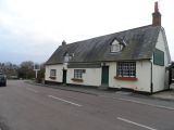
Robin Hood and Little John pub, Tonwell / Bikeboy, 2 Dec. 2013, Creative Commons, via Geograph.
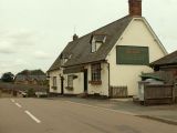
Robin Hood & Little John public house at Tonwell / Robert Edwards, 8 June 2009, Creative Commons, via Geograph.
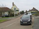
Tonwell: Ware Road and The Robin Hood and Little John / John Sutton, 14 Jan. 2018, Creative Commons, via Geograph.

