
Robin Hood Tavern (Upper Clapton): Difference between revisions
m (Text replacement - "embedformat=h4" to "embedformat=h3") |
mNo edit summary |
||
| Line 1: | Line 1: | ||
__NOTOC__{{PnItemTop|Lat=51.568707|Lon=-0.054176|AdmDiv=Middlesex|Vicinity=Bih Hill; High Hill Ferry, Upper Clapton|Type=Public house|Interest=Robin Hood name|Status=Defunct|Demonym=English|Riding=|GreaterLondon=Yes|Year=1794|Aka=Robin Hood; Ferry House; Ferry Tavern|Century=18|Cluster1=High Hill Ferry|Cluster2=|Cluster3=|Image= | __NOTOC__{{PnItemTop|Lat=51.568707|Lon=-0.054176|AdmDiv=Middlesex|Vicinity=Bih Hill; High Hill Ferry, Upper Clapton|Type=Public house|Interest=Robin Hood name|Status=Defunct|Demonym=English|Riding=|GreaterLondon=Yes|Year=1794|Aka=Robin Hood; Ferry House; Ferry Tavern|Century=18|Cluster1=High Hill Ferry|Cluster2=|Cluster3=|Image=Hackney Library Services 20xxa-r.jpg|Postcards=|ExtraCat1=|ExtraCat2=|ExtraCat3=|ExtraCat4=|ExtraCat5=|ExtraLink1=|ExtraLink2=|ExtraLink3=|ExtraLink4=|ExtraLink5=|ExtraLinkName1=|ExtraLinkName2=|ExtraLinkName3=|ExtraLinkName4=|ExtraLinkName5=|GeopointPrefix=|GeopointSuffix=|StatusSuffix=|DatePrefix=|DateSuffix=}} | ||
{{#display_map:{{#var:Coords}}~{{#replace:{{PAGENAME}}|'|'}}|width=34%}}<div class="pnMapLegend">The Robin Hood Tavern.</div> | {{#display_map:{{#var:Coords}}~{{#replace:{{PAGENAME}}|'|'}}|width=34%}}<div class="pnMapLegend">The Robin Hood Tavern.</div> | ||
[[File:{{#var:Pnimage}}|thumb|right|500px| | [[File:{{#var:Pnimage}}|thumb|right|500px|{{:Hackney Library Services 20xxa}} / Private collection.]] | ||
<p id="byline">By Henrik Thiil Nielsen, 2013-08-07. Revised by {{#realname:{{REVISIONUSER}}}}, {{REVISIONYEAR}}-{{REVISIONMONTH}}-{{REVISIONDAY2}}.</p> | <p id="byline">By Henrik Thiil Nielsen, 2013-08-07. Revised by {{#realname:{{REVISIONUSER}}}}, {{REVISIONYEAR}}-{{REVISIONMONTH}}-{{REVISIONDAY2}}.</p> | ||
<div class="no-img"> | <div class="no-img"> | ||
| Line 9: | Line 9: | ||
According to the latter website, the pub was "[o]riginally at Robin Hood Hill, then at High Hill Ferry, Upper Clapton by 1896".<ref>[http://pubshistory.com/LondonPubs/Hackney/RobinHoodPH.shtml Pub History: Robin Hood, High Hill Ferry, Upper Clapton E5.]</ref> No source is cited for this, and it must be noted that right from the first reference in the ''Proceedings of the Old Bailey'' (1794) – which is also the earliest known to UK Pub Hisory – the pub was located at High Hill Ferry. Unless "Robin Hood Hill" is simply a mistake, it may have been an alternative name for High Hill Ferry, but I have seen no record evidence for this. | According to the latter website, the pub was "[o]riginally at Robin Hood Hill, then at High Hill Ferry, Upper Clapton by 1896".<ref>[http://pubshistory.com/LondonPubs/Hackney/RobinHoodPH.shtml Pub History: Robin Hood, High Hill Ferry, Upper Clapton E5.]</ref> No source is cited for this, and it must be noted that right from the first reference in the ''Proceedings of the Old Bailey'' (1794) – which is also the earliest known to UK Pub Hisory – the pub was located at High Hill Ferry. Unless "Robin Hood Hill" is simply a mistake, it may have been an alternative name for High Hill Ferry, but I have seen no record evidence for this. | ||
The area where the pub stood now forms part of the [[Robin Hood Community Garden (Upper Clapton)|Robin Hood Community Garden]].{{ | The area where the pub stood now forms part of the [[Robin Hood Community Garden (Upper Clapton)|Robin Hood Community Garden]].{{PnItemQry}} | ||
== Sources == | == Sources == | ||
* [http://www.closedpubs.co.uk/london/e5_robinhood.html Lost Pubs Project: Robin Hood, Clapton, E5, London] | * [http://www.closedpubs.co.uk/london/e5_robinhood.html Lost Pubs Project: Robin Hood, Clapton, E5, London] | ||
| Line 23: | Line 23: | ||
== Notes == | == Notes == | ||
<references/> | <references/> | ||
| Line 30: | Line 29: | ||
{{ImgGalleryIntro}} | {{ImgGalleryIntro}} | ||
<gallery widths="195px"> | <gallery widths="195px"> | ||
File:Hackney Library Services 20xxa-r.jpg|{{:Hackney Library Services 20xxa}} / Private collection. | |||
File:robin-hood-tavern-upper-clapton-google-maps-street-view-2.jpg|This building has replaced the Robin Hood / Google Earth Street View. | File:robin-hood-tavern-upper-clapton-google-maps-street-view-2.jpg|This building has replaced the Robin Hood / Google Earth Street View. | ||
File:robin-hood-tavern-upper-clapton-google-maps-street-view.jpg|The sign of the Robin Hood has now found a home in [[Robin Hood Community Garden (Upper Clapton)|Robin Hood Community Garden]], a few meters north of the pub site / Google Maps Street View. | File:robin-hood-tavern-upper-clapton-google-maps-street-view.jpg|The sign of the Robin Hood has now found a home in [[Robin Hood Community Garden (Upper Clapton)|Robin Hood Community Garden]], a few meters north of the pub site / Google Maps Street View. | ||
Revision as of 08:25, 11 October 2018
[[File:|thumb|right|500px|Hackney Library Services. River Lea, Robin Hood c. 1900 (J.2) ([London], [20??]). Photographic postcard (monochrome). 137 x 87 mm. / Private collection.]]
By Henrik Thiil Nielsen, 2013-08-07. Revised by Henrik Thiil Nielsen, 2018-10-11.
First mentioned in 1794 (see Records below), the Robin Hood Tavern at High Hill Ferry, Upper Clapton, closed – and its precincts were demolished – in 2001. An 1851 trade directory and the 1861 census list it as the Ferry House. In the 19th century, the pub had its own fishery and the publican also operated the Robin Hood Ferry across the Lea.[1] Information on publicans from the period 1794–1944 culled from Proceedings of the Old Bailey, trade and Post Office directories, census records etc. can be found at UK Pub History.[2]
According to the latter website, the pub was "[o]riginally at Robin Hood Hill, then at High Hill Ferry, Upper Clapton by 1896".[3] No source is cited for this, and it must be noted that right from the first reference in the Proceedings of the Old Bailey (1794) – which is also the earliest known to UK Pub Hisory – the pub was located at High Hill Ferry. Unless "Robin Hood Hill" is simply a mistake, it may have been an alternative name for High Hill Ferry, but I have seen no record evidence for this.
The area where the pub stood now forms part of the Robin Hood Community Garden.Template:PnItemQry
Sources
- Lost Pubs Project: Robin Hood, Clapton, E5, London
- Pub History: Robin Hood, High Hill Ferry, Upper Clapton E5
- London Pubology: Robin Hood
- UK Pub Finder: Robin Hood Tavern, Clapton (E5), Greater London.
Brief mention
Notes
- ↑ See Pub History: Robin Hood, High Hill Ferry, Upper Clapton E5 and Lost Pubs Project: Robin Hood, Clapton, E5, London.
- ↑ Robin Hood, High Hill Ferry, Upper Clapton E5; London (North) 1896 Suburban Publicans directory listing - R; London, UK 1904 Suburban Publicans directory listing - R; London, UK 1911 Suburban directory listing - R; London, UK 1919 Suburban directory listing - R; The London Public Houses in the 1938 Post Office Directory - R; The London Public Houses in the 1944 Post Office Directory - Ri; East London Beer Guide & Pub directory in 1983 - E5 Clapton; East London Beer Guide & Pub directory in 1991 - E5 Clapton.
- ↑ Pub History: Robin Hood, High Hill Ferry, Upper Clapton E5.
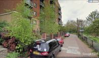
This building has replaced the Robin Hood / Google Earth Street View.
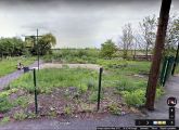
The sign of the Robin Hood has now found a home in Robin Hood Community Garden, a few meters north of the pub site / Google Maps Street View.


