
Robin Hood Lane (Walderslade)
From International Robin Hood Bibliography
Revision as of 02:58, 17 July 2018 by Henryfunk (talk | contribs) (Text replacement - "{{#ask:[[Category:Records ({{#ifeq:{{#pos:{{PAGENAME}}|(|}}||{{PAGENAME}}|{{#sub:{{PAGENAME}}|0| {{#expr:{{#pos:{{PAGENAME}}|(|}}-1}} }},{{#sub:{{PAGENAME}}|{{#expr:{{#pos:{{PAGENAME}}|(|}}-1}}|1}}{{#sub:{{PAGENAME}}|{{#expr:{{#pos:...)
Robin Hood Lane (Walderslade).
[[File:|thumb|right|500px|Robin Hood Lane / Google Earth Street View.]]
By Henrik Thiil Nielsen, 2018-01-10. Revised by Henrik Thiil Nielsen, 2018-07-17.
Robin Hood Lane in Walderslade, Chatham, runs east from Maidstone Road near Blue Bell Hill, stopping at Walderslade Woods (A2045) where it becomes a footbridge across the road, picking up on the east side of it as Robin Hood Lane (Lower).
Gazetteers
- Not included in Dobson, R. B., ed.; Taylor, J., ed. Rymes of Robyn Hood: an Introduction to the English Outlaw (London, 1976), pp. 293-311.
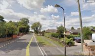
Robin Hood Lane / Google Earth Street View.
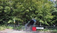
The footbridge connecting Robin Hood Lane and Robin Hood Lane (Lower) / Google Earth Street View.

