
Robin Hood Lane (Walderslade): Difference between revisions
From International Robin Hood Bibliography
m (Text replacement - "Pnimage" to "Image") |
m (Text replacement - "ImgGalleryIntro" to "ImageGalleryIntroduction") |
||
| (6 intermediate revisions by the same user not shown) | |||
| Line 1: | Line 1: | ||
__NOTOC__{{ | __NOTOC__{{PlaceNamesItemTop|Lat= 51.333427|Lon=0.512817|AdministrativeDivision=Kent|Vicinity=East from Maidstone Road towards Walderslade Woods (A2045), Walderslade, Chatham|Type=Thoroughfare|Interest=Robin Hood name| | ||
Status=Extant|Demonym=English|Riding=|GreaterLondon=|Year=|Aka=|Century=|Cluster1=Walderslade|Cluster2=|Cluster3=|Image=robin-hood-lane-walderslade-google-earth-street-view.jpg|Postcards=Yes|ExtraCat1=|ExtraCat2=|ExtraCat3=|ExtraCat4=|ExtraCat5=|ExtraLink1=|ExtraLink2=|ExtraLink3=|ExtraLink4=|ExtraLink5=|ExtraLinkName1=|ExtraLinkName2=|ExtraLinkName3=|ExtraLinkName4=|ExtraLinkName5=|GeopointPrefix=|GeopointSuffix=|VicinitySuffix=|StatusSuffix=|DatePrefix=|DateSuffix=}} | Status=Extant|Demonym=English|Riding=|GreaterLondon=|Year=|Aka=|Century=|Cluster1=Walderslade|Cluster2=|Cluster3=|Image=robin-hood-lane-walderslade-google-earth-street-view.jpg|Postcards=Yes|ExtraCat1=|ExtraCat2=|ExtraCat3=|ExtraCat4=|ExtraCat5=|ExtraLink1=|ExtraLink2=|ExtraLink3=|ExtraLink4=|ExtraLink5=|ExtraLinkName1=|ExtraLinkName2=|ExtraLinkName3=|ExtraLinkName4=|ExtraLinkName5=|GeopointPrefix=|GeopointSuffix=|VicinitySuffix=|StatusSuffix=|DatePrefix=|DateSuffix=}} | ||
{{#display_map:{{#var:Coords}}~{{#replace:{{PAGENAME}}|'|'}}|width=34%|enablefullscreen=yes}}<div class="pnMapLegend">{{PAGENAME}}.</div> | {{#display_map:{{#var:Coords}}~{{#replace:{{PAGENAME}}|'|'}}|width=34%|enablefullscreen=yes}}<div class="pnMapLegend">{{PAGENAME}}.</div> | ||
[[File:{{#var:Image}}|thumb|right|500px|Robin Hood Lane / Google Earth Street View.]]<div class="no-img"> | [[File:{{#var:Image}}|thumb|right|500px|Robin Hood Lane / Google Earth Street View.]]<div class="no-img"> | ||
<p id="byline">By Henrik Thiil Nielsen, 2018-01-10. Revised by {{#realname:{{REVISIONUSER}}}}, {{REVISIONYEAR}}-{{REVISIONMONTH}}-{{REVISIONDAY2}}.</p> | <p id="byline">By Henrik Thiil Nielsen, 2018-01-10. Revised by {{#realname:{{REVISIONUSER}}}}, {{REVISIONYEAR}}-{{REVISIONMONTH}}-{{REVISIONDAY2}}.</p> | ||
Robin Hood Lane in Walderslade, Chatham, runs east from Maidstone Road near Blue Bell Hill, stopping at Walderslade Woods (A2045) where it becomes a footbridge across the road, picking up on the east side of it as [[Robin Hood Lane (Lower) (Walderslade)|Robin Hood Lane (Lower)]].{{ | Robin Hood Lane in Walderslade, Chatham, runs east from Maidstone Road near Blue Bell Hill, stopping at Walderslade Woods (A2045) where it becomes a footbridge across the road, picking up on the east side of it as [[Robin Hood Lane (Lower) (Walderslade)|Robin Hood Lane (Lower)]].{{PlaceNamesItemAllusionsAndRecords}} | ||
== Gazetteers == | == Gazetteers == | ||
* Not included in {{:Dobson, Richard Barrie 1976a}}, pp. 293-311. | * Not included in {{:Dobson, Richard Barrie 1976a}}, pp. 293-311. | ||
{{ | {{PlaceNamesItemAlsoSee}} | ||
<!--== Notes == | <!--== Notes == | ||
<references/>--> | <references/>--> | ||
| Line 14: | Line 14: | ||
<div id="gallery"> | <div id="gallery"> | ||
{{ | {{ImageGalleryIntroduction}} | ||
<gallery widths="195px"> | <gallery widths="195px"> | ||
File:robin-hood-lane-walderslade-google-earth-street-view.jpg|thumb|right|500px|Robin Hood Lane / Google Earth Street View. | File:robin-hood-lane-walderslade-google-earth-street-view.jpg|thumb|right|500px|Robin Hood Lane / Google Earth Street View. | ||
| Line 22: | Line 22: | ||
</div> | </div> | ||
{{ | {{PlaceNamesItemNavigation}} | ||
Latest revision as of 13:53, 7 January 2021
| Locality | |
|---|---|
| Coordinate | 51.333427, 0.512817 |
| Adm. div. | Kent |
| Vicinity | East from Maidstone Road towards Walderslade Woods (A2045), Walderslade, Chatham |
| Type | Thoroughfare |
| Interest | Robin Hood name |
| Status | Extant |
| First Record | |
Robin Hood Lane (Walderslade).

By Henrik Thiil Nielsen, 2018-01-10. Revised by Henrik Thiil Nielsen, 2021-01-07.
Robin Hood Lane in Walderslade, Chatham, runs east from Maidstone Road near Blue Bell Hill, stopping at Walderslade Woods (A2045) where it becomes a footbridge across the road, picking up on the east side of it as Robin Hood Lane (Lower).
Gazetteers
- Not included in Dobson, R. B., ed.; Taylor, J., ed. Rymes of Robyn Hood: an Introduction to the English Outlaw (London, 1976), pp. 293-311.
Also see
Image gallery
Click any image to display it in the lightbox, where you can navigate between images by clicking in the right or left side of the current image.
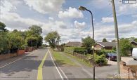
Robin Hood Lane / Google Earth Street View.
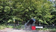
The footbridge connecting Robin Hood Lane and Robin Hood Lane (Lower) / Google Earth Street View.

