
Robin Hood Lane (Walderslade): Difference between revisions
From International Robin Hood Bibliography
m (Text replacement - "PnItemAlsoSee" to "PlaceNamesItemAlsoSee") |
m (Text replacement - "PlaceNamesItemQuery" to "PlaceNamesItemAllusionsAndRecords") |
||
| Line 4: | Line 4: | ||
[[File:{{#var:Image}}|thumb|right|500px|Robin Hood Lane / Google Earth Street View.]]<div class="no-img"> | [[File:{{#var:Image}}|thumb|right|500px|Robin Hood Lane / Google Earth Street View.]]<div class="no-img"> | ||
<p id="byline">By Henrik Thiil Nielsen, 2018-01-10. Revised by {{#realname:{{REVISIONUSER}}}}, {{REVISIONYEAR}}-{{REVISIONMONTH}}-{{REVISIONDAY2}}.</p> | <p id="byline">By Henrik Thiil Nielsen, 2018-01-10. Revised by {{#realname:{{REVISIONUSER}}}}, {{REVISIONYEAR}}-{{REVISIONMONTH}}-{{REVISIONDAY2}}.</p> | ||
Robin Hood Lane in Walderslade, Chatham, runs east from Maidstone Road near Blue Bell Hill, stopping at Walderslade Woods (A2045) where it becomes a footbridge across the road, picking up on the east side of it as [[Robin Hood Lane (Lower) (Walderslade)|Robin Hood Lane (Lower)]].{{ | Robin Hood Lane in Walderslade, Chatham, runs east from Maidstone Road near Blue Bell Hill, stopping at Walderslade Woods (A2045) where it becomes a footbridge across the road, picking up on the east side of it as [[Robin Hood Lane (Lower) (Walderslade)|Robin Hood Lane (Lower)]].{{PlaceNamesItemAllusionsAndRecords}} | ||
== Gazetteers == | == Gazetteers == | ||
* Not included in {{:Dobson, Richard Barrie 1976a}}, pp. 293-311. | * Not included in {{:Dobson, Richard Barrie 1976a}}, pp. 293-311. | ||
Revision as of 00:57, 6 January 2021
| Locality | |
|---|---|
| Coordinate | 51.333427, 0.512817 |
| Adm. div. | Kent |
| Vicinity | East from Maidstone Road towards Walderslade Woods (A2045), Walderslade, Chatham |
| Type | Thoroughfare |
| Interest | Robin Hood name |
| Status | Extant |
| First Record | |
Robin Hood Lane (Walderslade).

By Henrik Thiil Nielsen, 2018-01-10. Revised by Henrik Thiil Nielsen, 2021-01-06.
Robin Hood Lane in Walderslade, Chatham, runs east from Maidstone Road near Blue Bell Hill, stopping at Walderslade Woods (A2045) where it becomes a footbridge across the road, picking up on the east side of it as Robin Hood Lane (Lower).
Gazetteers
- Not included in Dobson, R. B., ed.; Taylor, J., ed. Rymes of Robyn Hood: an Introduction to the English Outlaw (London, 1976), pp. 293-311.
Also see
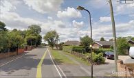
Robin Hood Lane / Google Earth Street View.
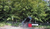
The footbridge connecting Robin Hood Lane and Robin Hood Lane (Lower) / Google Earth Street View.

