
Robin Hood Farm (Baslow): Difference between revisions
From International Robin Hood Bibliography
mNo edit summary |
m (Text replacement - "No Copy in NLS" to "No copy in NLS") |
||
| Line 16: | Line 16: | ||
== Maps == | == Maps == | ||
Maps of the area. | Maps of the area. | ||
* 25" O.S. map ''Derbyshire'' XXIV.2 (''c.'' 1879; surveyed ''c.'' 1878). No | * 25" O.S. map ''Derbyshire'' XXIV.2 (''c.'' 1879; surveyed ''c.'' 1878). No copy in NLS | ||
* [https://maps.nls.uk/view/114587717#zoom=4&lat=5125&lon=6147&layers=BT 25" O.S. map ''Derbyshire'' XXIV.2 (1898; rev. 1897)] | * [https://maps.nls.uk/view/114587717#zoom=4&lat=5125&lon=6147&layers=BT 25" O.S. map ''Derbyshire'' XXIV.2 (1898; rev. 1897)] | ||
* [https://maps.nls.uk/view/114587720#zoom=6&lat=5513&lon=6985&layers=BT 25" O.S. map ''Derbyshire'' XXIV.2 (1922; rev. 1919).] | * [https://maps.nls.uk/view/114587720#zoom=6&lat=5513&lon=6985&layers=BT 25" O.S. map ''Derbyshire'' XXIV.2 (1922; rev. 1919).] | ||
Latest revision as of 01:12, 13 February 2021
| Locality | |
|---|---|
| Coordinate | 53.245133, -1.580823 |
| Adm. div. | Derbyshire |
| Vicinity | Old Brampton Road, Baslow |
| Type | Building |
| Interest | Robin Hood name |
| Status | Extant |
| First Record | 2014 |
Robin Hood Farm, Bed & Breakfast.

Robin Hood Farm under renovation / Chris Morgan, 30 Jan. 2013; Creative Commons, via Geograph.
By Henrik Thiil Nielsen, 2013-08-07. Revised by Henrik Thiil Nielsen, 2021-02-13.
Robin Hood Farm on Old Brampton Road, in the hamlet of Robin Hood in the parish of Baslow and Bubnell, was in business as a bead & breakfast provider by 2014.
Robin Hood Farm bed & breakfast's FaceBook page was created in 2014.[1]
Gazetteers
- Dobson, R. B., ed.; Taylor, J., ed. Rymes of Robyn Hood: an Introduction to the English Outlaw (London, 1976), pp. 296, s.n. "Robin Hood".
Sources
- Cameron, Kenneth. The Place-Names of Derbyshire (English Place-Name Society, vols. XXVII-XXIX) (Cambridge, 1959), pt. I, p. 42.
Maps
Maps of the area.
- 25" O.S. map Derbyshire XXIV.2 (c. 1879; surveyed c. 1878). No copy in NLS
- 25" O.S. map Derbyshire XXIV.2 (1898; rev. 1897)
- 25" O.S. map Derbyshire XXIV.2 (1922; rev. 1919).
- 25" O.S. map of Baslow And Bubnell parish, Derbyshire (1950s) (georeferenced)
- 6" O.S. map Derbyshire Sheet XXIV.NW (1883; surveyed 1876–78)
- 6" O.S. map Derbyshire XXIV.NW (1899; rev. 1897) (georeferenced)
- 6" O.S. map Derbyshire Sheet XXIV.NW (1899; rev. 1897)
- 6" O.S. map Derbyshire XXIV (1923; rev. 1919–20)
- 6" O.S. map Derbyshire Sheet XXIV.NW (1923; rev. 1919–20).
Background
- FaceBook: Robin Hood Farm
- The Robin Hood Farm (Bed & Breakfast).
Also see
Notes
Image gallery
Click any image to display it in the lightbox, where you can navigate between images by clicking in the right or left side of the current image.
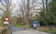
Robin Hood Farm under renovation / Chris Morgan, 30 Jan. 2013; Creative Commons, via Geograph.

Robin Hood Farm, Bed & Breakfast / Google Earth Street View
