
Robin Hood Court (Upper Thames Street): Difference between revisions
mNo edit summary |
mNo edit summary |
||
| Line 1: | Line 1: | ||
__NOTOC__{{PnItemTop|Lat=51.511231|Lon=-0.098069|AdmDiv=Middlesex|Vicinity=Upper Thames Street, ''c.'' 20 m E of Peter's Hill; close to the Millennium Bridge|Type=Area|Interest=Robin Hood name|Status=Defunct|Demonym=English|Riding=|GreaterLondon=Yes|Year=1720|Aka=|Century=|Cluster1=|Cluster2=|Cluster3=|Image=robin-hood-court-upper-thames-street-google-earth-street-view.jpg|Postcards=|Cat1=|Cat2=|Cat3=|Cat4=|Cat5=|Link1=|Link2=|Link3=|Link4=|Link5=|LinkText1=|LinkText2=|LinkText3=|LinkText4=|LinkText5=|GeopointPrefix=|GeopointSuffix=|StatusSuffix=|DatePrefix=|DateSuffix=}} | __NOTOC__{{PnItemTop|Lat=51.511231|Lon=-0.098069|AdmDiv=Middlesex|Vicinity=Upper Thames Street, ''c.'' 20 m E of Peter's Hill; close to the Millennium Bridge|Type=Area|Interest=Robin Hood name|Status=Defunct|Demonym=English|Riding=|GreaterLondon=Yes|Year=1720|Aka=Rob. Woods Court|Century=|Cluster1=|Cluster2=|Cluster3=|Image=robin-hood-court-upper-thames-street-google-earth-street-view.jpg|Postcards=|Cat1=|Cat2=|Cat3=|Cat4=|Cat5=|Link1=|Link2=|Link3=|Link4=|Link5=|LinkText1=|LinkText2=|LinkText3=|LinkText4=|LinkText5=|GeopointPrefix=|GeopointSuffix=|StatusSuffix=|DatePrefix=|DateSuffix=}} | ||
{{#display_map:{{#var:Coords}}~{{#replace:{{PAGENAME}}|'|'}}|width=34%}}<div class="pnMapLegend">Site of Robin Hood Court, Upper Thames Street.</div> | {{#display_map:{{#var:Coords}}~{{#replace:{{PAGENAME}}|'|'}}|width=34%}}<div class="pnMapLegend">Site of Robin Hood Court, Upper Thames Street.</div> | ||
[[File:{{#var:Pnimage}}|thumb|right|500px|Site of Robin Hood Court, Upper Thames Street / Google Earth Street View.]] | [[File:{{#var:Pnimage}}|thumb|right|500px|Site of Robin Hood Court, Upper Thames Street / Google Earth Street View.]] | ||
[[File:robin-hood-court-upper-thames-street-john-rocque-1746-locating-londons-past.jpg|thumb|right|500px|Robin Hood Court on John Rocque's map of London and Westminster (1746) / [https://www.locatinglondon.org Locating London's Past.]]] | [[File:robin-hood-court-upper-thames-street-john-rocque-1746-locating-londons-past.jpg|thumb|right|500px|Robin Hood Court on John Rocque's map of London and Westminster (1746) / [https://www.locatinglondon.org Locating London's Past.]]] | ||
<p id="byline">By Henrik Thiil Nielsen, 2018-06-27. Revised by {{#realname:{{REVISIONUSER}}}}, {{REVISIONYEAR}}-{{REVISIONMONTH}}-{{REVISIONDAY2}}.</p><div class="no-img"> | <p id="byline">By Henrik Thiil Nielsen, 2018-06-27. Revised by {{#realname:{{REVISIONUSER}}}}, {{REVISIONYEAR}}-{{REVISIONMONTH}}-{{REVISIONDAY2}}.</p><div class="no-img"> | ||
The now lost Robin Hood Court at Upper Thames Street is mentioned in John Strype's ''Survey of the Cities of London and Westminster'' (1720) and figures in several 18th century lists of London street and place-names. | |||
Harben in his entry on the locality refers to Ogilby and Morgan's 1677 map of London, but though the street appears to be indicated, it is not labelled on copies of the map available online.<ref name="harben">{{:Harben, Henry Andrade 1918a}}, p. 505, ''s.n.'' Robin Hood Court [3]. See Maps section for links to web versions of the map.</ref> | |||
{{#ask:[[Category:Records ({{#ifeq:{{#pos:{{PAGENAME}}|(|}}||{{PAGENAME}}|{{#sub:{{PAGENAME}}|0| {{#expr:{{#pos:{{PAGENAME}}|(|}}-1}} }},{{#sub:{{PAGENAME}}|{{#expr:{{#pos:{{PAGENAME}}|(|}}-1}}|1}}{{#sub:{{PAGENAME}}|{{#expr:{{#pos:{{PAGENAME}}|(|}}+1}}}}}}]]| format=embedded|embedformat=h4|columns=1|limit=1000|sort=Utitle|intro=<h3>Records</h3>}}{{#ask:[[Category:Allusions ({{#ifeq:{{#pos:{{PAGENAME}}|(|}}||{{PAGENAME}}|{{#sub:{{PAGENAME}}|0| {{#expr:{{#pos:{{PAGENAME}}|(|}}-1}} }},{{#sub:{{PAGENAME}}|{{#expr:{{#pos:{{PAGENAME}}|(|}}-1}}|1}}{{#sub:{{PAGENAME}}|{{#expr:{{#pos:{{PAGENAME}}|(|}}+1}}}}}}]]| format=embedded|embedformat=h4|columns=1|limit=1000|sort=Utitle|intro=<h3>Allusions</h3>}} | {{#ask:[[Category:Records ({{#ifeq:{{#pos:{{PAGENAME}}|(|}}||{{PAGENAME}}|{{#sub:{{PAGENAME}}|0| {{#expr:{{#pos:{{PAGENAME}}|(|}}-1}} }},{{#sub:{{PAGENAME}}|{{#expr:{{#pos:{{PAGENAME}}|(|}}-1}}|1}}{{#sub:{{PAGENAME}}|{{#expr:{{#pos:{{PAGENAME}}|(|}}+1}}}}}}]]| format=embedded|embedformat=h4|columns=1|limit=1000|sort=Utitle|intro=<h3>Records</h3>}}{{#ask:[[Category:Allusions ({{#ifeq:{{#pos:{{PAGENAME}}|(|}}||{{PAGENAME}}|{{#sub:{{PAGENAME}}|0| {{#expr:{{#pos:{{PAGENAME}}|(|}}-1}} }},{{#sub:{{PAGENAME}}|{{#expr:{{#pos:{{PAGENAME}}|(|}}-1}}|1}}{{#sub:{{PAGENAME}}|{{#expr:{{#pos:{{PAGENAME}}|(|}}+1}}}}}}]]| format=embedded|embedformat=h4|columns=1|limit=1000|sort=Utitle|intro=<h3>Allusions</h3>}} | ||
=== Gazetteers === | |||
=== Sources ===--> | * {{:Dobson, Richard Barrie 1976a}}, p. 300, ''s.n.'' Robin Hood Court [2] | ||
* {{:Harben, Henry Andrade 1918a}}, p. 505, ''s.n.'' Robin Hood Court [3] | |||
<!--=== Sources ===--> | |||
=== Maps === | === Maps === | ||
* {{:Ogilby, John 1677a}} | |||
** [http://www.british-history.ac.uk/no-series/london-map-ogilby-morgan/1676 British History Online] | |||
** [http://british-library.georeferencer.com/map/tZhzP2P0wma4LPL34zCGXs/201407121539-l8vhPJ/visualize British Library: Online Gallery] (zoomable overlay) | |||
** [http://www.britishmuseum.org/research/collection_online/collection_object_details.aspx?objectId=3100981&partId=1 British Museum: Collection Online] | |||
** [https://upload.wikimedia.org/wikipedia/commons/e/e5/Maps_Of_Old_London_Ogilby.jpg Wikimedia Commons: Maps of Old London: Ogilby.] | |||
* {{:Rocque, John 1746a}}. | |||
* [https://maps.nls.uk/view/103313321#zoom=4&lat=2485&lon=12961&layers=BT 25" O.S. map ''London'' (1915- Numbered sheets) V.10 (1936; rev. 1914)] | * [https://maps.nls.uk/view/103313321#zoom=4&lat=2485&lon=12961&layers=BT 25" O.S. map ''London'' (1915- Numbered sheets) V.10 (1936; rev. 1914)] | ||
* [http://maps.nls.uk/geo/explore/#zoom=17&lat=51.5118&lon=-0.0976&layers=168&b=5 25" O.S. map ''London'' (1915- Numbered sheets) V.10 (1936; rev. 1914)] (georeferenced)] | * [http://maps.nls.uk/geo/explore/#zoom=17&lat=51.5118&lon=-0.0976&layers=168&b=5 25" O.S. map ''London'' (1915- Numbered sheets) V.10 (1936; rev. 1914)] (georeferenced)] | ||
Revision as of 22:25, 27 June 2018
[[File:|thumb|right|500px|Site of Robin Hood Court, Upper Thames Street / Google Earth Street View.]]

By Henrik Thiil Nielsen, 2018-06-27. Revised by Henrik Thiil Nielsen, 2018-06-27.
The now lost Robin Hood Court at Upper Thames Street is mentioned in John Strype's Survey of the Cities of London and Westminster (1720) and figures in several 18th century lists of London street and place-names.
Harben in his entry on the locality refers to Ogilby and Morgan's 1677 map of London, but though the street appears to be indicated, it is not labelled on copies of the map available online.[1]
Allusions
1720 - Strype, John - Survey of London and Westminster (07)
This Street [sc. Thames Street] enjoyeth a good Trade, and hath a great Resort, occasioned by the several Wharfs on the Water side: and therefore much pestered with Carts. Black Boy Alley, long and narrow, having a great Diers at the lower end. Boss Alley, also long and narrow, with a Diers by the Thames side. Betwixt this Place and Black Boy Alley, is a large passage to Wood Wharf. Robin Hood Court, but very ordinary. Trig Stairs, so called from the Stairs on the Water side, which is indifferently well supplied by Watermen. The Lane is pretty open, reasonably well built and inhabited. Castle Lane, pretty broad for Carts, having a Wood Wharf at the lower end; the Buildings are but ordinary, as are the Inhabitants. George Yard, being good and large, and taken up by Timber Merchants and Wood Wharfs at the lower end. Broken Wharf. By this is a Water House to convey the Thames Water in Pipes. Which of late Years hath been much improved, as to the Revenue, to what it was at first, by the Industry of those concerned therein; but not managed without a great Charge, in keeping so many Servants, and Horses for the forcing the Water up into the Cistern at the top of the Building, which is very lofty.[2]
Gazetteers
- Dobson, R. B., ed.; Taylor, J., ed. Rymes of Robyn Hood: an Introduction to the English Outlaw (London, 1976), p. 300, s.n. Robin Hood Court [2]
- Harben, Henry A., compil.; [Greaves, I.I., ed.]. A Dictionary of London: Being Notes Topographical and Historical Relating to the Streets and Principal Buildings in the City of London (London, 1918), p. 505, s.n. Robin Hood Court [3]
Maps
- Ogilby, John, cartog.; Morgan, William, cartog. Large and Accurate Map of the City of London ([s.l.], [1677])
- Rocque, John, cartog.; Pine, John, engr. A Plan of the Cities of London and Westminster, and Borough of Southwark (London, 1746).
- 25" O.S. map London (1915- Numbered sheets) V.10 (1936; rev. 1914)
- 25" O.S. map London (1915- Numbered sheets) V.10 (1936; rev. 1914) (georeferenced)]
- 6" O.S. map Middlesex XVII (1880-82; surveyed 1868-73)
- 6" O.S. map Surrey III (1880; surveyed 1868-73)
- 6" O.S. map London VII.SW (1894-96; rev. 1893-95)
- 6" O.S. map Surrey III.NW (1898; rev. 1893-95)
- 6" O.S. map Surrey III.NW (1898; rev. 1893-95) (georeferenced)
- 6" O.S. map London Sheet K (1920; rev. 1913-14)
- 6" O.S. map London Sheet K (c. 1946; rev. 1938).
Notes
- ↑ Harben, Henry A., compil.; [Greaves, I.I., ed.]. A Dictionary of London: Being Notes Topographical and Historical Relating to the Streets and Principal Buildings in the City of London (London, 1918), p. 505, s.n. Robin Hood Court [3]. See Maps section for links to web versions of the map.
- ↑ John Strype's A Survey of the Cities of London and Westminster, Book 3, Ch. 10, p. 218 (hriOnline).

Site of Robin Hood Court, Upper Thames Street / Google Earth Street View.
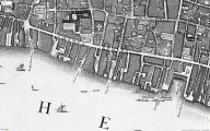
Robin Hood Court on John Rocque's map of London and Westminster (1746) / Locating London's Past.
