
Robin Hood Court (St Martin-in-the-Fields): Difference between revisions
m (Text replacement - "<div class="no-img"><p id="byline">" to "<div class="no-img"> <p id="byline">") |
mNo edit summary |
||
| Line 4: | Line 4: | ||
[[File:robin-hood-st-martin-in-the-fields-john-rocque-locating-londons-past.jpg|thumb|right|500px|Detail of John Rocque's 1746 ''Plan of London'', centred on the site of Robin Hood Court in the space between New Round Court and Church Lane / [https://www.locatinglondon.org Locating London's Past: John Rocque's ''Plan''.]]<div class="no-img"> | [[File:robin-hood-st-martin-in-the-fields-john-rocque-locating-londons-past.jpg|thumb|right|500px|Detail of John Rocque's 1746 ''Plan of London'', centred on the site of Robin Hood Court in the space between New Round Court and Church Lane / [https://www.locatinglondon.org Locating London's Past: John Rocque's ''Plan''.]]<div class="no-img"> | ||
<p id="byline">By Henrik Thiil Nielsen, 2018-07-16. Revised by {{#realname:{{REVISIONUSER}}}}, {{REVISIONYEAR}}-{{REVISIONMONTH}}-{{REVISIONDAY2}}.</p> | <p id="byline">By Henrik Thiil Nielsen, 2018-07-16. Revised by {{#realname:{{REVISIONUSER}}}}, {{REVISIONYEAR}}-{{REVISIONMONTH}}-{{REVISIONDAY2}}.</p> | ||
Robin Hood Court near St Martin-in-the-Fields only appears to be recorded from 1682 to 1728. | |||
''A New Review of London'' (1728) lists the locality as | The earliest reference is William Morgan's 1682 map of London, where the form 'Rabinhood Court' is cited.<ref>{{:Morgan, William 1904a}}, No. 73 in the list of 'References for Westminster etc<sup>a</sup>. Beginning with N<sup>o</sup>. 1. S<sup>r</sup>. Tho: Clargis house in Portugal Street and ending at 419 Bishops-Head Court in Grays Inne Lane': 'Rabinhood Court'.</ref> | ||
John Strype in 1720 mentions 'Robin Hood Court, very ordinary, and ill built' (see Allusions below), between Church Lane and New Round Court, on the north side of the Strand. This would have been at or very near the present 437 Strand. Since the names of Robin Hood Courts and Alleys in London tended to be inspired by the presence of a public house named after the outlaw, in particular its often large and conspicuous inn sign, it is very likely there once was a Robin Hood pub in Robin Hood Court. | |||
''A New Review of London'' (1728) lists the locality as 'Robin hood's court ''against'' york-buildings',<ref>{{:Anonymous 1728a}}, ''s.n.'' Robin hood's court. Letter casing and italic type as printed there.</ref> the latter being a name 'once used generically for all the premises on the site of York House'.<ref>[http://www.british-history.ac.uk/survey-london/vol18/pt2/pp81-83 British History Online: York Buildings.]</ref> After this time Robin Hood Court seems to have vanished, for it is not included in any of the later directories I have seen or on John Rocque's 1746 map (see detail below and see Maps section). | |||
There was another Robin Hood Court on the north side of the Strand, for this see [[Robin Hood Court (St Clement Danes)]]. | There was another Robin Hood Court on the north side of the Strand, for this see [[Robin Hood Court (St Clement Danes)]]. | ||
Revision as of 10:20, 6 July 2020
[[File:|thumb|right|500px|437 Strand, the site of Robin Hood Court / Google Maps Street View.]]

By Henrik Thiil Nielsen, 2018-07-16. Revised by Henrik Thiil Nielsen, 2020-07-06.
Robin Hood Court near St Martin-in-the-Fields only appears to be recorded from 1682 to 1728.
The earliest reference is William Morgan's 1682 map of London, where the form 'Rabinhood Court' is cited.[1]
John Strype in 1720 mentions 'Robin Hood Court, very ordinary, and ill built' (see Allusions below), between Church Lane and New Round Court, on the north side of the Strand. This would have been at or very near the present 437 Strand. Since the names of Robin Hood Courts and Alleys in London tended to be inspired by the presence of a public house named after the outlaw, in particular its often large and conspicuous inn sign, it is very likely there once was a Robin Hood pub in Robin Hood Court.
A New Review of London (1728) lists the locality as 'Robin hood's court against york-buildings',[2] the latter being a name 'once used generically for all the premises on the site of York House'.[3] After this time Robin Hood Court seems to have vanished, for it is not included in any of the later directories I have seen or on John Rocque's 1746 map (see detail below and see Maps section).
There was another Robin Hood Court on the north side of the Strand, for this see Robin Hood Court (St Clement Danes). Template:PnItemQry
Gazetteers
- Not included in Dobson, R. B., ed.; Taylor, J., ed. Rymes of Robyn Hood: an Introduction to the English Outlaw (London, 1976), pp. 293-11.
Sources
Maps
- Rocque, John, cartog.; Pine, John, engr. A Plan of the Cities of London and Westminster, and Borough of Southwark (London, 1746)
- Horwood, Richard, cartog. Plan of the Cities of London and Westminster, the Borough of Southwark, and Parts adjoining Shewing every House (London, 1792-99)
- 25" O.S. map London (1915- Numbered sheets) V.10 (1936; rev. 1914)
- 25" O.S. map London (1915- Numbered sheets) V.10 (1936; rev. 1914) (georeferenced)
- 6" O.S. map Middlesex XVII (1880-82; surveyed 1868-73)
- 6" O.S. map Surrey III (1880; surveyed 1868-73)
- 6" O.S. map London VII.SW (1894-96; rev. 1893-95)
- 6" O.S. map Surrey III.NW (1898; rev. 1893-95)
- 6" O.S. map London Sheet K (1920; rev. 1913-14)
- 6" O.S. map London Sheet K (c. 1946; rev. 1938).
Background
Notes
- ↑ Morgan, Wm., cartog.; Morden, Robt., cartog.; Lea, Phil., cartog. London &c. Actually Survey'd [and] A Prospect of London and Westminster Taken at Several Stations to the Southward thereof (London, 1904), No. 73 in the list of 'References for Westminster etca. Beginning with No. 1. Sr. Tho: Clargis house in Portugal Street and ending at 419 Bishops-Head Court in Grays Inne Lane': 'Rabinhood Court'.
- ↑ Anonymous. A New Review of London: being an Exact Survey, lately taken, of every Street, Lane, Court, Alley, Square, Close, Green, Wharf, Row, Garden, Field, and aLl Places, by what Name soever call'd, within the Cities, Liberties, or Suburbs of London, Westminster, and the Borough of Southwark. 3rd ed. (London, 1728), s.n. Robin hood's court. Letter casing and italic type as printed there.
- ↑ British History Online: York Buildings.
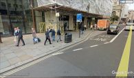
437 Strand, the site of Robin Hood Court / Google Maps Street View.
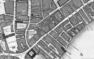
Detail of John Rocque's 1746 Plan of London, centred on the site of Robin Hood Court in the space between New Round Court and Church Lane / Locating London's Past: John Rocque's Plan.
