
Robin Hood Cemetery (Solihull): Difference between revisions
From International Robin Hood Bibliography
m (Text replacement - "PnItemNav" to "PlaceNamesItemNavigation") |
m (Text replacement - "PnItemAlsoSee" to "PlaceNamesItemAlsoSee") |
||
| Line 10: | Line 10: | ||
== Background == | == Background == | ||
* [http://www.geograph.org.uk/photo/981371 Geograph: SP1280: Robin Hood Cemetery.] | * [http://www.geograph.org.uk/photo/981371 Geograph: SP1280: Robin Hood Cemetery.] | ||
{{ | {{PlaceNamesItemAlsoSee}} | ||
== Notes == | == Notes == | ||
<references/> | <references/> | ||
Revision as of 00:42, 6 January 2021
| Locality | |
|---|---|
| Coordinate | 52.4207, -1.821275 |
| Adm. div. | Warwickshire |
| Vicinity | Streetsbrook Road, Solihull |
| Type | Establishment |
| Interest | Robin Hood name |
| Status | Extant |
| First Record | 1917 |

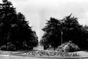
Entrance to the cemetery / Roy Hughes, 31 May 2011, Creative Commons, via Geograph.
Robin Hood Cemetery.
By Henrik Thiil Nielsen, 2013-08-07. Revised by Henrik Thiil Nielsen, 2021-01-06.
Robin Hood Cemetery in Streetsbrook Road, Solihull, opened in 1917 and closed for new grave burials in 1992, when Widney Manor Cemetery replaced it as the Solihull's principal cemetery.[1] In the Robin Hood Cemetery is the Robin Hood Crematorium. Administratively the two form a unit known as Robin Hood Cemetery and Crematorium. Template:PlaceNamesItemQuery
Gazetteers
- Not included in Dobson, R. B., ed.; Taylor, J., ed. Rymes of Robyn Hood: an Introduction to the English Outlaw (London, 1976), pp. 293-311.
Background
Also see
Notes

Robin Hood Cemetery, Streetsbrook Road/Olton Road Entrance / Roy Hughes, 31 May 2011, Creative Commons, via Geograph.
Robin Hood Cemetery / Keith Yardley, 1954, uploaded by 'Tiger', Creative Commons, via Geograph.
