
Robin Hood Allotment Gardens (Carlton, Nottingham) (1): Difference between revisions
m (Text replacement - "|service=leaflet}}" to "|service=leaflet|enablefullscreen=yes}}") |
rh>Henryfunk mNo edit summary |
||
| Line 22: | Line 22: | ||
== Notes == | == Notes == | ||
<references/>--> | <references/>--> | ||
</div> | |||
<div id="gallery"> | |||
< | |||
{{ImgGalleryIntro}} | {{ImgGalleryIntro}} | ||
<gallery widths="195px"> | <gallery widths="195px"> | ||
| Line 30: | Line 30: | ||
File:robin-hood-allotment-gardens-carlton-2-google-earth-street-view.jpg|Top: former site of the Robin Hood Allotment Gardens. Bottom: their present location / Google Earth Street View. | File:robin-hood-allotment-gardens-carlton-2-google-earth-street-view.jpg|Top: former site of the Robin Hood Allotment Gardens. Bottom: their present location / Google Earth Street View. | ||
</gallery> | </gallery> | ||
</div> | |||
{{PnItemNav}} | {{PnItemNav}} | ||
Revision as of 11:17, 15 May 2020

By Henrik Thiil Nielsen, 2017-11-12. Revised by 18.117.81.240, 2020-05-15.
Robin Hood Allotment Gardens in Carlton, which is now a Nottingham suburb, are first found included on a 6" O.S. map of the area published in 1900. By 1947, if not by 1938, the allotment gardens had been moved from their first location, immediately N. of Coningswath Road, to the south side of the road and west of Cavendish Road, the latter being their official address (see maps in Maps section below). Template:PnItemQry
Gazetteers
- Not included in Dobson, R. B., ed.; Taylor, J., ed. Rymes of Robyn Hood: an Introduction to the English Outlaw (London, 1976), pp. 293-311.
Maps
- 25" O.S. map Nottinghamshire XXXVIII.15 (1900; rev. 1899)
- 25" O.S. map Nottinghamshire XXXVIII.15 (1914; rev. 1913)
- 6" O.S. map Nottinghamshire XXXVIII.SE (1885; surveyed 1878-83) (allotment gardens not indicated)
- 6" O.S. map Nottinghamshire XXXVIII.SE (1901; rev. 1899) (georeferenced)
- 6" O.S. map Nottinghamshire XXXVIII.SE (1901; rev. 1899)
- 6" O.S. map Nottinghamshire XXXVIII.SE (1920; rev. 1919)
- 6" O.S. map Nottinghamshire XXXVIII.SE (1947; rev. 1938) (allotment gardens at new location, indicated without name).

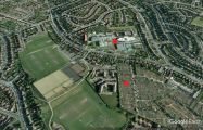
Former location of Robin Hood Allotment Gardens, now that of the Carlton Academy and Carlton Forum Leisure Centre / Google Earth Street View.
Top: former site of the Robin Hood Allotment Gardens. Bottom: their present location / Google Earth Street View.
