
Robin Hood (Tunbridge Wells)
| Locality | |
|---|---|
| Coordinate | 51.14453, 0.282684 |
| Adm. div. | Kent |
| Vicinity | 2 Birken Road, Tunbridge Wells |
| Type | Public house |
| Interest | Robin Hood name |
| Status | Extant |
| First Record | 1971 |
| A.k.a. | Robin Hood Hungry Horse |

By Henrik Thiil Nielsen, 2020-11-09. Revised by Henrik Thiil Nielsen, 2021-02-13. Some contents courtesy Paul Skelton, webmaster of Kent's Public House Archive Site.
The still existing Robin Hood at 2 Birken Road, Tunbridge Wells, opened in 1971.
The pub is situated in a neighbourhood of Tunbridge Wells known as Sherwood, which inspired the names of several streets, businesses and facilities there. The pub is situated on the northwest corner of Birken and Sandhurst roads in a house built in 1912 and used as a private home until it was converted into the Robin Hood in 1971. The pub has changed owners and publicans several times over the years. In 1997 it was owned by Whitbread Medway Inns, in 2007 by Enterprise Inc PLC. Major alterations and refurbishmenst were undertaken and the premises were considerably enlarged in 2007. The pub closed in September 2012 but was purchased by Green King and reopened on 20 January 2013 as "'Robin Hood' Hungry Horse". It was renovated again in October 2018.[1]
Gazetteers
- Not included in Dobson, R. B., ed.; Taylor, J., ed. Rymes of Robyn Hood: an Introduction to the English Outlaw (London, 1976), pp. 293-311.
Sources
Maps
- 25" O.S. map Kent LX.8 (c. 1873; surveyed 1866). No copy in NLS
- 25" O.S. map Kent LX.12 (c. 1873; surveyed 1866-68). No copy in NLS
- 25" O.S. map Kent LX.8 (1897; rev. 1895) (georeferenced)
- 25" O.S. map Kent LX.8 (1897; rev. 1895)
- 25" O.S. map Kent LX.12 (1897; rev. 1895)
- 25" O.S. map Kent LX.8 (1909; rev. 1907)
- 25" O.S. map Kent LX.12 (1909; rev. 1907)
- 25" O.S. map Kent LX.8 (1941; rev. 1936–37)
- 25" O.S. map Kent LX.12 (1945; rev. 1936–37)
- 6" O.S. map Kent LX (1872; surveyed 1868–69)
- 6" O.S. map Sussex VII (1878; surveyed 1873)
- 6" O.S. map Kent LX.NE (1898; rev. 1895) (georeferenced)
- 6" O.S. map Kent LX.NE (1898; rev. 1895)
- 6" O.S. map Kent LX.NE (1910; rev. 1907)
- 6" O.S. map Kent LX.NE (c. 1947; rev. 1938)
- 6" O.S. map Kent LX.NE (c. 1951; rev. 1938).
Background
Also see
Notes
- ↑ The source for most of this is Dover Kent Archives: Robin Hood, Sandhurst Road, Royal Tunbridge Wells, written and compiled by Edward James Gilbert.
Image gallery
Click any image to display it in the lightbox, where you can navigate between images by clicking in the right or left side of the current image.
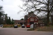
The Robin Hood, Birken Road / N. Chadwick, 28 Feb. 2009; Creative Commons, via Geograph.
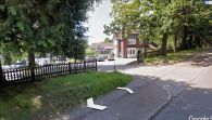
The Robin Hood, Tunbridge Wells / Google Earth Street View.
