
Robin Hood (Tring): Difference between revisions
m (Text replacement - "Creative Commons via Geograph" to "Creative Commons, via Geograph") |
rh>Henryfunk mNo edit summary |
||
| Line 33: | Line 33: | ||
* [http://www.therobinhoodtring.co.uk/gallery/ The Robin Hood, Tring: Gallery;] exteriors and interiors of recent date. | * [http://www.therobinhoodtring.co.uk/gallery/ The Robin Hood, Tring: Gallery;] exteriors and interiors of recent date. | ||
{{PnItemAlsoSee}} | {{PnItemAlsoSee}} | ||
== Notes == | == Notes == | ||
<references/> | <references/> | ||
</div> | |||
< | <div id="gallery"> | ||
{{ImgGalleryIntro}} | {{ImgGalleryIntro}} | ||
<gallery widths="195px"> | <gallery widths="195px"> | ||
| Line 54: | Line 54: | ||
IMAG0024.jpg|The Robin Hood ''c.'' 2005 / [http://www.therobinhoodtring.co.uk/gallery/4mp859-digital-camera-6/ Pub website.] | IMAG0024.jpg|The Robin Hood ''c.'' 2005 / [http://www.therobinhoodtring.co.uk/gallery/4mp859-digital-camera-6/ Pub website.] | ||
</gallery> | </gallery> | ||
</div> | |||
{{PnItemNav}} | {{PnItemNav}} | ||
Revision as of 17:09, 15 May 2020
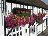
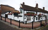
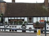
[[File:|thumb|right|500px|The "Robin Hood", Tring / Gerald Massey, 26 Oct. 2009, Creative Commons, via Geograph.]]
By Henrik Thiil Nielsen, 2013-08-07. Revised by 18.216.233.58, 2020-05-15.
Betwen them the pub's unusually informative website and the UK Pub History site provide a good deal of information on publicans and residents during the years 1841 to 1937.[3]Template:PnItemQry
Gazetteers
- Not included in Dobson, R. B., ed.; Taylor, J., ed. Rymes of Robyn Hood: an Introduction to the English Outlaw (London, 1976), pp. 293-311.
Sources
Maps
- 25" O.S. map Hertfordshire XXV.14 (c. 1879; surveyed 1877). No Copy in NLS
- 25" O.S. map Hertfordshire XXV.14 (1899; rev. 1897) (georeferenced)
- 25" O.S. map Hertfordshire XXV.14 (1899; rev. 1897)
- 25" O.S. map Hertfordshire XXV.14 (1924; rev. 1922)
- 6" O.S. map Buckinghamshire XXXIV (1883-84; surveyed 1877)
- 6" O.S. map Hertfordshire XXV (1884; surveyed 1877-79)
- 6" O.S. map Buckinghamshire XXXIV.NE (1900; rev. 1897-98) (georeferenced)
- 6" O.S. map Buckinghamshire XXXIV.NE (1900; rev. 1897-98)
- 6" O.S. map Hertfordshire XXV.SW (1900; rev. 1897)
- 6" O.S. map Hertfordshire XXV.SW (1926; rev. 1922-23)
- 6" O.S. map Hertfordshire XXV.SW (c. 1948; rev. 1938)
- 6" O.S. map Hertfordshire XXV.SW (1952; rev. 1950).
Background
- Facebook: The Robin Hood, Tring
- The Robin Hood, Tring: Gallery; exteriors and interiors of recent date.
Notes
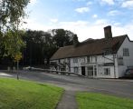
The "Robin Hood", Tring / Gerald Massey, 26 Oct. 2009, Creative Commons, via Geograph.
The "Robin Hood", Tring / Gerald Massey, 12 Sep. 2009, Creative Commons, via Geograph.
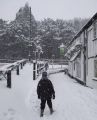
The Robin Hood and snowy footpath / Rob Farrow, 8 Feb. 2007, Creative Commons, via Geograph.
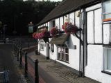
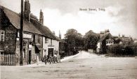
Robin Hood Pub, Tring. At the corner of the Lower High Street and Brook Street / Gerald Massey, 12 Sep. 2009, Creative Commons, via Geograph.
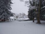
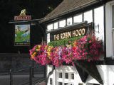
The Robin Hood from the Memorial Gardens, Tring / Rob Farrow, 8 Feb. 2007, Creative Commons, via Geograph.
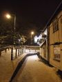
Pavement past the Robin Hood / Rob Farrow, 20 Jan. 2013, Creative Commons, via Geograph.
Robin Hood Pub, Tring. At the corner of the Lower High Street and Brook Street / Gerald Massey, 12 Sep. 2009, Creative Commons, via Geograph.
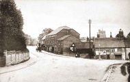
The Robin Hood c. 1900 / Pub website.
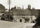
The Robin Hood c. 1905 / Pub website.
The Robin Hood c. 1905 / Pub website.
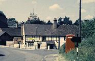
The Robin Hood c. 1960s / Pub website.
The Robin Hood c. 1999 / Pub website.
The Robin Hood c. 2005 / Pub website.


