
Robin Hood (St Mary Cray): Difference between revisions
m (Text replacement - "embedformat=h4" to "embedformat=h3") |
m (Text replacement - "ImgGalleryIntro" to "ImageGalleryIntroduction") |
||
| (29 intermediate revisions by 2 users not shown) | |||
| Line 1: | Line 1: | ||
__NOTOC__{{ | __NOTOC__{{PlaceNamesItemTop|Lat= 51.395622|Lon=0.106810|AdministrativeDivision=Kent|Vicinity=Corner of Chipperfield Road and Sayes Court Road: now named Scarlet Close|Type=Public house|Interest=Robin Hood name| | ||
Status=Defunct|Demonym=|Riding=|GreaterLondon=Yes|Year= | Status=Defunct|Demonym=|Riding=|GreaterLondon=Yes|Year=1959|Aka=|Century=20|Cluster1=St Mary Cray|Cluster2=|Cluster3=|Image=robin-hood-chipperfield-road-st-mary-cray-google-earth-street-view-1.jpg|Postcards=|ExtraCat1=|ExtraCat2=|ExtraCat3=|ExtraCat4=|ExtraCat5=|ExtraLink1=|ExtraLink2=|ExtraLink3=|ExtraLink4=|ExtraLink5=|ExtraLinkName1=|ExtraLinkName2=|ExtraLinkName3=|ExtraLinkName4=|ExtraLinkName5=|GeopointPrefix=|GeopointSuffix=|VicinitySuffix=|StatusSuffix=|DatePrefix=|DateSuffix=}} | ||
{{#display_map:{{#var:Coords}}~{{#replace:{{PAGENAME}}|'|'}}|width=34%}}<div class="pnMapLegend">The site of the Robin Hood.</div> | {{#display_map:{{#var:Coords}}~{{#replace:{{PAGENAME}}|'|'}}|width=34%|enablefullscreen=yes}}<div class="pnMapLegend">The site of the Robin Hood.</div> | ||
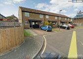
[[File:{{#var: | [[File:{{#var:Image}}|thumb|right|500px|The site of the Robin Hood, at Scarlet Close / Google Earth Street View.]]<div class="no-img"> | ||
<p id="byline">By Henrik Thiil Nielsen, 2017-12-25. Revised by {{#realname:{{REVISIONUSER}}}}, {{REVISIONYEAR}}-{{REVISIONMONTH}}-{{REVISIONDAY2}}.</p | <p id="byline">By Henrik Thiil Nielsen, 2017-12-25. Revised by {{#realname:{{REVISIONUSER}}}}, {{REVISIONYEAR}}-{{REVISIONMONTH}}-{{REVISIONDAY2}}. Includes information kindly contributed by Eric E. Rush.</p> | ||
There was a public house named the Robin Hood at the corner of Chipperfield and Sayes Court roads in St Mary Cray, the present address of the site being Scarlet Court.<ref name="pubology">[http://www.pubology.co.uk/pubs/7595.html London Pubology: Robin Hood.]</ref> | There was a public house named the Robin Hood at the corner of Chipperfield and Sayes Court roads in St Mary Cray, the present address of the site being Scarlet Court.<ref name="pubology">[http://www.pubology.co.uk/pubs/7595.html London Pubology: Robin Hood.]</ref> While there is no evidence of this, it seems likely that the pub's name was inspired either by that of a long defunct pub of the same name in the area, [[Robin Hood (St Paul's Wood Hill)|Robin Hood at St Paul's Wood Hill]], or that of [[Robin Hood Shaw (St Mary Cray)|Robin Hood Shaw]] ''c.'' 850 m to the north-northeast. | ||
The pub is included in a (more recently compiled?) 'List of Wenlock Brewery Co. Ltd pubs' as of 1936.<ref>[http://www.pubology.co.uk/pubs/7595.html London Pubology: Robin Hood], referring to [http://www.breweryhistory.com/wiki/index.php?title=List_of_Wenlock_Brewery_Co._Ltd_pubs List of Wenlock Brewery Co. Ltd pubs], item No. 174.</ref> However, Eric Rush, who hails from this area, tells me he does not remember it existing before the 1950s. He suggest 1959 as a likely year of establishment and notes that it had only one licensee during its existence.<ref>Mail of 28 June 2020 from Eric Rush to Henrik Thiil Nielsen.</ref> Until someone can prove the latter statement wrong, IRHB accepts this date. | |||
{{ | |||
There is also some uncertainty as to when the pub closed. According to one site listing closed pubs this happened after 2000.<ref>[https://whatpub.com/pubs/BRO/15081/robin-hood-st-mary-cray Campaign for Real Ale: What ?ub: Robin Hood]</ref> The excellent London Pubology cites the date 'c2000', while also noting that the pub was 'demolished c1992'.<ref name="pubology"/> However, the pub site's planning application historiography shows that applications to change the use from public house to offices etc. were sought and granted in 1991. These were withdrawn, but permission to demolish the existing buildings and construct 14 two-bedroom houses with associated parking spaces etc. was granted on 21 May 1992. Final details were only settled on 16 June 1993, but it seems possible demolition could have happened any time after 21 May 1992. As the permission was valid for five years, a new application would have been required if work had started after 21 May 1997 (or perhaps 16 June 1998), but clearly this was not the case.<ref>[https://searchapplications.bromley.gov.uk/online-applications/propertyDetails.do?activeTab=relatedCases&keyVal=0030JTBTLI000 Borough of Bromley: Property History.]</ref> | |||
The following existing addresses are also referred to in the planning records: 61-63-65-67, 69, 71 and 73 Sayes Court Road, while the following new ones were created: 1-2-3-4-5-6-7 Scarlet Close.<ref>[https://searchapplications.bromley.gov.uk/online-applications/applicationDetails.do?activeTab=relatedCases&keyVal=9102027FUL Borough of Bromley: Planning: Application-Related Items]</ref> Did the pub buildings also occupy 61-73 Sayes Court Road? | |||
{{PlaceNamesItemAllusionsAndRecords}} | |||
== Gazetteers == | == Gazetteers == | ||
* Not included in {{:Dobson, Richard Barrie 1976a}}, pp. 293-311. | * Not included in {{:Dobson, Richard Barrie 1976a}}, pp. 293-311. | ||
== Maps == | == Maps == | ||
The Robin Hood is not | The Robin Hood is not included in these maps. | ||
* 25" O.S. map ''Kent'' XVI.3 (''c.'' 1868; surveyed 1867) | * 25" O.S. map ''Kent'' XVI.3 (''c.'' 1868; surveyed 1867). No copy in NLS | ||
* [http://maps.nls.uk/view/103676720#zoom=4&lat=5603&lon=8735&layers=BT 25" O.S. map ''Kent'' XVI.3 (1896; rev. 1895)] | * [http://maps.nls.uk/view/103676720#zoom=4&lat=5603&lon=8735&layers=BT 25" O.S. map ''Kent'' XVI.3 (1896; rev. 1895)] | ||
* [http://maps.nls.uk/geo/explore/#zoom=17&lat=51.3959&lon=0.1078&layers=168&b=1 25" O.S. map ''Kent'' XVI.3 (1896; rev. 1895)] (georeferenced) | * [http://maps.nls.uk/geo/explore/#zoom=17&lat=51.3959&lon=0.1078&layers=168&b=1 25" O.S. map ''Kent'' XVI.3 (1896; rev. 1895)] (georeferenced) | ||
| Line 38: | Line 42: | ||
* [https://searchapplications.bromley.gov.uk/online-applications/propertyDetails.do?activeTab=relatedCases&keyVal=0030JTBTLI000 Borough of Bromley: Property History] | * [https://searchapplications.bromley.gov.uk/online-applications/propertyDetails.do?activeTab=relatedCases&keyVal=0030JTBTLI000 Borough of Bromley: Property History] | ||
* [https://whatpub.com/pubs/BRO/15081/robin-hood-st-mary-cray Campaign for Real Ale: What ?ub: Robin Hood] | * [https://whatpub.com/pubs/BRO/15081/robin-hood-st-mary-cray Campaign for Real Ale: What ?ub: Robin Hood] | ||
* [http://www.breweryhistory.com/wiki/index.php?title=List_of_Wenlock_Brewery_Co._Ltd_pubs Brewery History Society Wiki: List of Wenlock Brewery Co. Ltd pubs], item No. 174. | * [http://www.breweryhistory.com/wiki/index.php?title=List_of_Wenlock_Brewery_Co._Ltd_pubs Brewery History Society Wiki: List of Wenlock Brewery Co. Ltd pubs], item No. 174 | ||
* [http://www.breweryhistory.com/wiki/index.php?title=List_of_Wenlock_Brewery_Co._Ltd_pubs List of Wenlock Brewery Co. Ltd Pubs]; see item #174 | |||
* [http://www.pubology.co.uk/pubs/7595.html London Pubology: Robin Hood.] | * [http://www.pubology.co.uk/pubs/7595.html London Pubology: Robin Hood.] | ||
== Photos == | |||
* {{:Waller, Phil 2019a}}, p. 104. | |||
== Background == | == Background == | ||
* [https://en.wikipedia.org/wiki/Orpington_Urban_District Wikipedia: Orpington Urban District.] | * [https://en.wikipedia.org/wiki/Orpington_Urban_District Wikipedia: Orpington Urban District.] | ||
* [https://en.wikipedia.org/wiki/St_Mary_Cray Wikipedia: St Mary Cray.] | * [https://en.wikipedia.org/wiki/St_Mary_Cray Wikipedia: St Mary Cray.] | ||
{{PlaceNamesItemAlsoSee}} | |||
{{ | |||
== Notes == | == Notes == | ||
<references/> | <references/> | ||
</div> | |||
< | <div id="gallery"> | ||
{{ | {{ImageGalleryIntroduction}} | ||
<gallery widths="195px"> | <gallery widths="195px"> | ||
File:robin-hood-chipperfield-road-st-mary-cray-google-earth-street-view-1.jpg|thumb|right|500px|The site of the Robin Hood. Scarlet Close / Google Earth Street View. | File:robin-hood-chipperfield-road-st-mary-cray-google-earth-street-view-1.jpg|thumb|right|500px|The site of the Robin Hood. Scarlet Close / Google Earth Street View. | ||
File:robin-hood-chipperfield-road-st-mary-cray-google-earth-street-view-2.jpg|thumb|right|500px|The site of the Robin Hood. Sayes Court Road / Google Earth Street View. | File:robin-hood-chipperfield-road-st-mary-cray-google-earth-street-view-2.jpg|thumb|right|500px|The site of the Robin Hood. Sayes Court Road / Google Earth Street View. | ||
</gallery> | </gallery> | ||
</div> | |||
{{ | {{PlaceNamesItemNavigation}} | ||
Latest revision as of 13:53, 7 January 2021
| Locality | |
|---|---|
| Coordinate | 51.395622, 0.10681 |
| Adm. div. | Kent, now Greater London |
| Vicinity | Corner of Chipperfield Road and Sayes Court Road: now named Scarlet Close |
| Type | Public house |
| Interest | Robin Hood name |
| Status | Defunct |
| First Record | 1959 |

By Henrik Thiil Nielsen, 2017-12-25. Revised by Henrik Thiil Nielsen, 2021-01-07. Includes information kindly contributed by Eric E. Rush.
There was a public house named the Robin Hood at the corner of Chipperfield and Sayes Court roads in St Mary Cray, the present address of the site being Scarlet Court.[1] While there is no evidence of this, it seems likely that the pub's name was inspired either by that of a long defunct pub of the same name in the area, Robin Hood at St Paul's Wood Hill, or that of Robin Hood Shaw c. 850 m to the north-northeast.
The pub is included in a (more recently compiled?) 'List of Wenlock Brewery Co. Ltd pubs' as of 1936.[2] However, Eric Rush, who hails from this area, tells me he does not remember it existing before the 1950s. He suggest 1959 as a likely year of establishment and notes that it had only one licensee during its existence.[3] Until someone can prove the latter statement wrong, IRHB accepts this date.
There is also some uncertainty as to when the pub closed. According to one site listing closed pubs this happened after 2000.[4] The excellent London Pubology cites the date 'c2000', while also noting that the pub was 'demolished c1992'.[1] However, the pub site's planning application historiography shows that applications to change the use from public house to offices etc. were sought and granted in 1991. These were withdrawn, but permission to demolish the existing buildings and construct 14 two-bedroom houses with associated parking spaces etc. was granted on 21 May 1992. Final details were only settled on 16 June 1993, but it seems possible demolition could have happened any time after 21 May 1992. As the permission was valid for five years, a new application would have been required if work had started after 21 May 1997 (or perhaps 16 June 1998), but clearly this was not the case.[5]
The following existing addresses are also referred to in the planning records: 61-63-65-67, 69, 71 and 73 Sayes Court Road, while the following new ones were created: 1-2-3-4-5-6-7 Scarlet Close.[6] Did the pub buildings also occupy 61-73 Sayes Court Road?
Gazetteers
- Not included in Dobson, R. B., ed.; Taylor, J., ed. Rymes of Robyn Hood: an Introduction to the English Outlaw (London, 1976), pp. 293-311.
Maps
The Robin Hood is not included in these maps.
- 25" O.S. map Kent XVI.3 (c. 1868; surveyed 1867). No copy in NLS
- 25" O.S. map Kent XVI.3 (1896; rev. 1895)
- 25" O.S. map Kent XVI.3 (1896; rev. 1895) (georeferenced)
- 25" O.S. map Kent XVI.3 (1908; rev. 1907)
- 25" O.S. map Kent XVI.3 (1932; rev. 1930-31)
- 25" O.S. map Kent XVI.3 (1947; rev. 1937-38)
- 6" O.S. map Kent XVI (1871; surveyed 1862-68)
- 6" O.S. map Kent XVI.NE (1898; rev. 1895) (georeferenced)
- 6" O.S. map Kent XVI.NE (1898; rev. 1895)
- 6" O.S. map Kent XVI.NE (1910; rev. 1907-1908)
- 6" O.S. map London Sheet T (1919; rev. 1914)
- 6" O.S. map Kent XVI.NE (c. 1938; rev. 1930-1931)
- 6" O.S. map Kent XVI.NE (c. 1944; rev. 1938)
- 6" O.S. map Kent XVI.NE (c. 1945; rev. c. 1938)
- 6" O.S. map London Sheet T (c. 1946; rev. 1938) (only partly revised)
- 1:25,000 map TQ46 (1957)
- 1" O.S. map Sheet 271 (Hills) (1896)
- 1" O.S. map Sheet 271 (Outline) (1896)
- 1" O.S. map Sheet 171 (1946)
- 1" O.S. map Sheet 171 (1961).
Sources
- Borough of Bromley: Planning: Application-Related Items
- Borough of Bromley: Property History
- Campaign for Real Ale: What ?ub: Robin Hood
- Brewery History Society Wiki: List of Wenlock Brewery Co. Ltd pubs, item No. 174
- List of Wenlock Brewery Co. Ltd Pubs; see item #174
- London Pubology: Robin Hood.
Photos
Background
Also see
Notes
- ↑ 1.0 1.1 London Pubology: Robin Hood.
- ↑ London Pubology: Robin Hood, referring to List of Wenlock Brewery Co. Ltd pubs, item No. 174.
- ↑ Mail of 28 June 2020 from Eric Rush to Henrik Thiil Nielsen.
- ↑ Campaign for Real Ale: What ?ub: Robin Hood
- ↑ Borough of Bromley: Property History.
- ↑ Borough of Bromley: Planning: Application-Related Items
Image gallery
Click any image to display it in the lightbox, where you can navigate between images by clicking in the right or left side of the current image.
The site of the Robin Hood. Scarlet Close / Google Earth Street View.
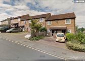
The site of the Robin Hood. Sayes Court Road / Google Earth Street View.
