Robin Hood (Mottram Moor)
From International Robin Hood Bibliography
| Locality | |
|---|---|
| Coordinate | 53.459969, -2.000055 |
| Adm. div. | Cheshire |
| Vicinity | c. 40 m east of Carrhouse Lane, on S side of A57 in Mottram Moor, near Mottram in Longdendale |
| Type | Public house |
| Interest | Robin Hood name |
| Status | Defunct |
| First Record | 1798 |
| A.k.a. | Robin Hood Inn |
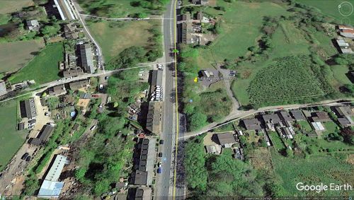
The site of the Robin Hood.
By Henrik Thiil Nielsen, 2021-06-18. Revised by Henrik Thiil Nielsen, 2021-06-18.
The Robin Hood Inn in Mottram Moor – between Mottram in Longdendale and Hollingworth – was situated c. 40 metres east of Carrhouse Lane, on the south side of the A57. It was in existence by 1798.
By the latter date it had become a meeting place for the local freemasons. It has been suggested that it was built c. 1770.[1] It appears in records at least as late as 1936. When the level of the A57 was raised, the building became isolated. It was converte into a private residence but was severly damaged by fire in the 1960 and was then demolished.[1]
Gazetteers
- Not included in Dobson, R. B., ed.; Taylor, J., ed. Rymes of Robyn Hood: an Introduction to the English Outlaw (London, 1976), pp. 293-311.
Sources
Maps
- 25" O.S. map Cheshire XI.3 (1886; surveyed 1872)
- 25" O.S. map Cheshire XI.3 (1898; rev. 1896) (georeferenced)
- 25" O.S. map Cheshire XI.3 (1898; rev. 1896)
- 25" O.S. map Cheshire XI.3 (1910; rev. 1907)
- 25" O.S. map Cheshire XI.3 (1938; rev. 1933–36)
- 6" O.S. map Cheshire XI (1882; surveyed 1872)
- 6" O.S. map Cheshire XI.NE (1899; rev. 1896–97) (georeferenced)
- 6" O.S. map Cheshire XI.NE (1899; rev. 1896–97)
- 6" O.S. map Cheshire XI.NE (1911; rev. 1907)
- 6" O.S. map Derbyshire II (1924; rev. 1919)
- 6" O.S. map Cheshire XI.NE (c. 1945; rev. 1938)
- 6" O.S. map Cheshire XI.NE (c. 1950; rev. 1938).
Also see
Notes

