
Robin Hood (Mottram Moor): Difference between revisions
mNo edit summary |
mNo edit summary |
||
| Line 1: | Line 1: | ||
__NOTOC__{{PlaceNamesItemTop|Lat=53.459969|Lon=-2.000055|AdministrativeDivision=Cheshire|Vicinity=''c.'' 40 m east of Carrhouse Lane, on S side of A57 in Mottram Moor, near Mottram in Longdendale|Type=Public house|Interest=Robin Hood name| | __NOTOC__{{PlaceNamesItemTop|Lat=53.459969|Lon=-2.000055|AdministrativeDivision=Cheshire|Vicinity=''c.'' 40 m east of Carrhouse Lane, on S side of A57 in Mottram Moor, near Mottram in Longdendale|Type=Public house|Interest=Robin Hood name| | ||
Status=Defunct|Demonym=|Riding=|GreaterLondon=|Year=1798|Aka=Robin Hood Inn|Century=|Cluster1=|Cluster2=|Cluster3=|Image=robin-hood-mottram-moor-google-earth.jpg|Postcards=|ExtraCat1=|ExtraCat2=|ExtraCat3=|ExtraCat4=|ExtraCat5=|ExtraLink1=|ExtraLink2=|ExtraLink3=|ExtraLink4=|ExtraLink5=|ExtraLinkName1=|ExtraLinkName2=|ExtraLinkName3=|ExtraLinkName4=|ExtraLinkName5=|GeopointPrefix=|GeopointSuffix=|VicinitySuffix=|StatusSuffix=|DatePrefix=|DateSuffix=}} | Status=Defunct|Demonym=|Riding=|GreaterLondon=|Year=1798|Aka=Robin Hood Inn|Century=|Cluster1=Mottram Moor|Cluster2=|Cluster3=|Image=robin-hood-mottram-moor-google-earth.jpg|Postcards=|ExtraCat1=|ExtraCat2=|ExtraCat3=|ExtraCat4=|ExtraCat5=|ExtraLink1=|ExtraLink2=|ExtraLink3=|ExtraLink4=|ExtraLink5=|ExtraLinkName1=|ExtraLinkName2=|ExtraLinkName3=|ExtraLinkName4=|ExtraLinkName5=|GeopointPrefix=|GeopointSuffix=|VicinitySuffix=|StatusSuffix=|DatePrefix=|DateSuffix=}} | ||
{{#display_map:{{#var:Coords}}~{{#replace:{{PAGENAME}}|'|'}}|width=34%|fullscreen=yes}}<div class="pnMapLegend">The site of the Robin Hood.</div> | {{#display_map:{{#var:Coords}}~{{#replace:{{PAGENAME}}|'|'}}|width=34%|fullscreen=yes}}<div class="pnMapLegend">The site of the Robin Hood.</div> | ||
[[File:{{#var:Image}}|thumb|right|500px|The Robin Hood was located here / Google Earth Street View (click or tap to enlarge).]] | [[File:{{#var:Image}}|thumb|right|500px|The Robin Hood was located here / Google Earth Street View (click or tap to enlarge).]] | ||
Revision as of 16:07, 18 June 2021
| Locality | |
|---|---|
| Coordinate | 53.459969, -2.000055 |
| Adm. div. | Cheshire |
| Vicinity | c. 40 m east of Carrhouse Lane, on S side of A57 in Mottram Moor, near Mottram in Longdendale |
| Type | Public house |
| Interest | Robin Hood name |
| Status | Defunct |
| First Record | 1798 |
| A.k.a. | Robin Hood Inn |

By Henrik Thiil Nielsen, 2021-06-18. Revised by Henrik Thiil Nielsen, 2021-06-18.
The Robin Hood Inn in Mottram Moor – between Mottram in Longdendale and Hollingworth – was situated c. 40 metres east of Carrhouse Lane, on the south side of the A57. It was in existence by 1798.
The freemason 'Lodge of Loyalty' held its meetings there from its founding in 1798 but had moved to another public house by 1816.[1] It has been suggested that the pub was built c. 1770.[2]
The 1845 tithe award for Mottram in Longendale lists the 'Robin Hood Public House' with John Tollemache, Esq., as landowner, John Beard as occupier, a land area of 39 roods (986.42 m2), and nothing entered under 'State of Cultivation'.[3] John Beard was still publican in 1860.[4] The Robin Hood was a Wilsons Brewery pub.[5] When the level of the A57 was raised, the building became isolated. It was subsequently converted into a private residence but was severly damaged by fire in the 1960.[2] It was subsequently demolished, probably in 1977, though according to others this was in the 1960s.[6]
Gazetteers
- Not included in Dobson, R. B., ed.; Taylor, J., ed. Rymes of Robyn Hood: an Introduction to the English Outlaw (London, 1976), pp. 293-311.
MS sources
- Tithe award for the township of Mottram in Longdendale, online at the TheGenealogist, Piece 05, Sub-Piece 277, Image 017, #238 (£)
- Accompanying map, online at the TheGenealogist, Piece 05, Sub-Piece 277, Sub-Image 001 (£).
Printed and web sources
- Brewery History: List of Wilsons Brewery Ltd pubs, #69.
- Bygone Boozers of Greater Manchester: Robin Hood Inn (Mottram, Hyde)
- Museum of Freemasonry: Lane's Masonic Records: Lodge of Loyalty (320)
- Pubs Of The Past Glossop & Hadfield R.I.P.
- White's History, Gazetteer & Directory of Cheshire, 1860: Entries for the Longdendale, Disley and Marple areas.
Maps
- 25" O.S. map Cheshire XI.3 (1886; surveyed 1872)
- 25" O.S. map Cheshire XI.3 (1898; rev. 1896) (georeferenced)
- 25" O.S. map Cheshire XI.3 (1898; rev. 1896)
- 25" O.S. map Cheshire XI.3 (1910; rev. 1907)
- 25" O.S. map Cheshire XI.3 (1938; rev. 1933–36)
- 6" O.S. map Cheshire XI (1882; surveyed 1872)
- 6" O.S. map Cheshire XI.NE (1899; rev. 1896–97) (georeferenced)
- 6" O.S. map Cheshire XI.NE (1899; rev. 1896–97)
- 6" O.S. map Cheshire XI.NE (1911; rev. 1907)
- 6" O.S. map Derbyshire II (1924; rev. 1919)
- 6" O.S. map Cheshire XI.NE (c. 1945; rev. 1938)
- 6" O.S. map Cheshire XI.NE (c. 1950; rev. 1938).
Also see
Notes
- ↑ Museum of Freemasonry: Lane's Masonic Records: Lodge of Loyalty (320).
- ↑ 2.0 2.1 Bygone Boozers of Greater Manchester: Robin Hood Inn (Mottram, Hyde).
- ↑ Tithe award for the township of Mottram in Longdendale, online at the TheGenealogist, Piece 05, Sub-Piece 277, Image 017, #238 (£); accompanying map, online at the TheGenealogist, Piece 05, Sub-Piece 277, Sub-Image 001 (£).
- ↑ White's History, Gazetteer & Directory of Cheshire, 1860: Entries for the Longdendale, Disley and Marple areas.
- ↑ Brewery History: List of Wilsons Brewery Ltd pubs, #69.
- ↑ 1977 according to Pubs Of The Past Glossop & Hadfield R.I.P; 1960s according to Bygone Boozers of Greater Manchester: Robin Hood Inn (Mottram, Hyde).
Image gallery
Click any image to display it in the lightbox, where you can navigate between images by clicking in the right or left side of the current image.
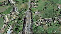
The Robin Hood was located here / Google Earth Street View (click or tap to enlarge).
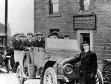
Outing from the Robin Hood c. 1920 / Bygone Boozers of Greater Manchester: Robin Hood Inn (Mottram, Hyde)
