
Robin Hood (Gosport): Difference between revisions
From International Robin Hood Bibliography
m (Text replacement - "Pnimage" to "Image") |
m (Text replacement - "AdmDiv" to "AdministrativeDivision") |
||
| Line 1: | Line 1: | ||
__NOTOC__{{PnItemTop|Lat=50.790477|Lon=-1.134056| | __NOTOC__{{PnItemTop|Lat=50.790477|Lon=-1.134056|AdministrativeDivision=Hampshire|Vicinity=1 Mayfield Road, Gosport|Type=Public house|Interest=Robin Hood name| | ||
Status=Defunct|Demonym=|Riding=|GreaterLondon=|Year=1891|Aka=|Century=|Cluster1=Portsmouth|Cluster2=|Cluster3=|Image=robin-hood-gosport-google-earth-street-view.jpg|Postcards=|ExtraCat1=|ExtraCat2=|ExtraCat3=|ExtraCat4=|ExtraCat5=|ExtraLink1=|ExtraLink2=|ExtraLink3=|ExtraLink4=|ExtraLink5=|ExtraLinkName1=|ExtraLinkName2=|ExtraLinkName3=|ExtraLinkName4=|ExtraLinkName5=|GeopointPrefix=|GeopointSuffix=|VicinitySuffix=|StatusSuffix=|DatePrefix=|DateSuffix=}} | Status=Defunct|Demonym=|Riding=|GreaterLondon=|Year=1891|Aka=|Century=|Cluster1=Portsmouth|Cluster2=|Cluster3=|Image=robin-hood-gosport-google-earth-street-view.jpg|Postcards=|ExtraCat1=|ExtraCat2=|ExtraCat3=|ExtraCat4=|ExtraCat5=|ExtraLink1=|ExtraLink2=|ExtraLink3=|ExtraLink4=|ExtraLink5=|ExtraLinkName1=|ExtraLinkName2=|ExtraLinkName3=|ExtraLinkName4=|ExtraLinkName5=|GeopointPrefix=|GeopointSuffix=|VicinitySuffix=|StatusSuffix=|DatePrefix=|DateSuffix=}} | ||
{{#display_map:{{#var:Coords}}~{{#replace:{{PAGENAME}}|'|'}}|width=34%|fullscreen=yes}}<div class="pnMapLegend">{{PAGENAME}}.</div> | {{#display_map:{{#var:Coords}}~{{#replace:{{PAGENAME}}|'|'}}|width=34%|fullscreen=yes}}<div class="pnMapLegend">{{PAGENAME}}.</div> | ||
Revision as of 21:25, 5 January 2021
Robin Hood (Gosport).
[[File:|thumb|right|500px|The former Robin Hood / Google Earth Street View.]]
By Henrik Thiil Nielsen, 2020-05-27. Revised by Henrik Thiil Nielsen, 2021-01-05.
The Robin Hood at 1 Mayfield Road, Gosport, first appears in the records in 1891. It closed in 2006.
Information on publicans etc. for the years 1891–1927 can be found at Pub Wiki.[1] Template:PnItemQry
Gazetteers
- Not included in Dobson, R. B., ed.; Taylor, J., ed. Rymes of Robyn Hood: an Introduction to the English Outlaw (London, 1976), pp. 293-311.
Sources
- Closed Pubs: Hampshire > Gosport > Robin Hood.
- Pub Wiki: Robin Hood, 1 Mayfield road, Gosport, Hampshire.
Maps
- 25" O.S. map Hampshire and Isle of Wight LXXXIII.10 (c. 1860; surveyed 1856). No Copy in NLS
- 25" O.S. map Hampshire and Isle of Wight LXXXIII.10 (1898; rev. 1896) (georeferenced)
- 25" O.S. map Hampshire and Isle of Wight LXXXIII.10 (1898; rev. 1896)
- 25" O.S. map Hampshire and Isle of Wight LXXXIII.10 (1910; rev. 1906)
- 25" O.S. map Hampshire and Isle of Wight LXXXIII.10 (1932; rev. 1931)
- 25" O.S. map Hampshire and Isle of Wight LXXXIII.10 (1939; rev. 1936)
- 6" O.S. map Hampshire & Isle of Wight LXXXIII.SW (1898; rev. 1896) (georeferenced)
- 6" O.S. map Hampshire & Isle of Wight LXXXIII (c. 1871; surveyed 1856)
- 6" O.S. map Hampshire & Isle of Wight LXXXIII.SW (1898; rev. 1896)
- 6" O.S. map Hampshire & Isle of Wight LXXXIII.SW (1910; rev. 1906–07)
- 6" O.S. map Hampshire & Isle of Wight LXXXIII.SW (c. 1933; rev. 1931)
- 6" O.S. map Hampshire & Isle of Wight LXXXIII.SW (c. 1942; rev. 1940)
- 6" O.S. map Hampshire & Isle of Wight LXXXIII.SW (c. 1943; rev. 1938)
- 6" O.S. map Hampshire & Isle of Wight LXXXIII.SW (c. 1946; rev. 1938).
Notes
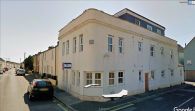
The former Robin Hood / Google Earth Street View.
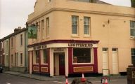
The Robin Hood / Barry Shimmon, 15 Mar. 1987; Creative Commons, via Geograph.
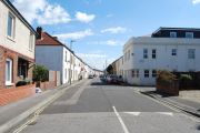
Mayfield Road with the former Robin Hood right / Barry Shimmon, 16 Apr. 2012; Creative Commons, via Geograph.

_-_geograph.org.uk_-_1445260.jpg)