
Robin Hood's Stable (Papplewick): Difference between revisions
mNo edit summary |
rh>Henryfunk mNo edit summary |
||
| Line 24: | Line 24: | ||
== Notes == | == Notes == | ||
<references/> | <references/> | ||
</div> | </div> | ||
<div id="gallery"> | |||
{{ImgGalleryIntro}} | {{ImgGalleryIntro}} | ||
<gallery widths="195px"> | <gallery widths="195px"> | ||
| Line 33: | Line 32: | ||
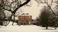
File:geograph-3296628-by-David-Hallam-Jones.jpg|thumb|right|500px|A view of Papplewick Hall from the B836, Blidworth Waye (''sic''). It was built between 1781-87 for the Hon. Frederick Montagu and is thought to be designed by William Lindley of Doncaster. It is now divided into privately owned apartments / [http://www.geograph.org.uk/photo/3296628 David Hallam-Jones, Creative Commons, via Geograph.] | File:geograph-3296628-by-David-Hallam-Jones.jpg|thumb|right|500px|A view of Papplewick Hall from the B836, Blidworth Waye (''sic''). It was built between 1781-87 for the Hon. Frederick Montagu and is thought to be designed by William Lindley of Doncaster. It is now divided into privately owned apartments / [http://www.geograph.org.uk/photo/3296628 David Hallam-Jones, Creative Commons, via Geograph.] | ||
</gallery> | </gallery> | ||
</div> | |||
{{PnItemNav}} | {{PnItemNav}} | ||
Revision as of 16:26, 15 May 2020

By Henrik Thiil Nielsen, 2016-10-10. Revised by 3.144.16.254, 2020-05-15.
Robin Hood's Stable is a cave cut into sandstone, located c. 150 m NNE of Papplewick Hall. Neither Dobson & Taylor nor the English Place-Name Society's volume on Nottingham provide any references. The earliest source I have found so far is John Throsby's interesting description with its accompanying illustrations (see Allusions section below). The 'stable' is included on the 6" O.S. map of the area published in 1884 (see Maps section below)[1]
The Thoroton referred to in the 1790 allusion is Robert Thoroton, whose Antiquities of Nottinghamshire (1677) was expanded almost beyond recognition by John Throsby in 1790 (see Sources and Background sections below). Template:PnItemQry
Gazetteers
- Dobson, R. B., ed.; Taylor, J., ed. Rymes of Robyn Hood: an Introduction to the English Outlaw (London, 1976), p. 303, s.n. 'Robin Hood's Stable'.
Sources
- Gover, J.E.B.; Mawer, Allen; Stenton, F.M. The Place-Names of Nottinghamshire (English Place-Name Society, vol. XVII) (Cambridge, 1940), pp. 131, 294.
Maps
- 25" O.S. map Nottinghamshire XXIII.5 (1900; rev. 1899)
- 6" O.S. map Nottinghamshire XXXIII.NW (1884; surveyed 1878-83)
- 6" O.S. map Nottinghamshire XXXIII.NW (1900; rev. 1899)
Background
- Thoroton, Robert. The Antiquities of Nottinghamshire: Extracted out of Records, Original Evidences, Leiger Books, Other Manuscripts, and Authentick Authorities (London, 1677). The original work which Throsby (see 1790 Allusion) expanded almost beyond recognition.
Notes
A view of Papplewick Hall from the B836, Blidworth Waye (sic). It was built between 1781-87 for the Hon. Frederick Montagu and is thought to be designed by William Lindley of Doncaster. It is now divided into privately owned apartments / David Hallam-Jones, Creative Commons, via Geograph.
