Robin Hood's Stable (Papplewick): Difference between revisions
mNo edit summary |
mNo edit summary |
||
| Line 3: | Line 3: | ||
<p id="byline">By Henrik Thiil Nielsen, 2016-10-10. Revised by {{#realname:{{REVISIONUSER}}}}, {{REVISIONYEAR}}-{{REVISIONMONTH}}-{{REVISIONDAY2}}.</p> | <p id="byline">By Henrik Thiil Nielsen, 2016-10-10. Revised by {{#realname:{{REVISIONUSER}}}}, {{REVISIONYEAR}}-{{REVISIONMONTH}}-{{REVISIONDAY2}}.</p> | ||
<div class="no-img"> | <div class="no-img"> | ||
Robin Hood's Stable is a cave cut into sandstone, located ''c.'' 150 m NNE of Papplewick Hall. Neither Dobson & Taylor nor the English Place-Name Society's volume on Nottingham provide any references. The earliest source I have found so far is John | Robin Hood's Stable is a cave cut into sandstone, located ''c.'' 150 m NNE of Papplewick Hall. Neither Dobson & Taylor nor the English Place-Name Society's volume on Nottingham provide any references. The earliest source I have found so far is John Throsby's interesting description with its accompanying illustrations (see Allusions section below). The 'stable' is included on the 6" O.S. map of the area published in 1884 (see Maps section below)<ref>{{:Dobson, Richard Barrie 1976a}}, p. 303, ''s.n.'' 'Robin Hood's Stable'; {{:Gover, John Eric Bruce 1940a}}, pp. 131, 294.</ref> | ||
=== Allusions === | === Allusions === | ||
| Line 22: | Line 22: | ||
</div> | </div> | ||
{{ImgGalleryIntro}} | |||
<gallery widths="195px"> | |||
File:Thoroton-robert -1797-ii-287.jpg|{{:Thoroton, Robert 1797a}}, vol. II, p. 287. | |||
</gallery> | |||
{{PnItemNav}} | {{PnItemNav}} | ||
Revision as of 13:45, 13 January 2018
By Henrik Thiil Nielsen, 2016-10-10. Revised by Henrik Thiil Nielsen, 2018-01-13.
Robin Hood's Stable is a cave cut into sandstone, located c. 150 m NNE of Papplewick Hall. Neither Dobson & Taylor nor the English Place-Name Society's volume on Nottingham provide any references. The earliest source I have found so far is John Throsby's interesting description with its accompanying illustrations (see Allusions section below). The 'stable' is included on the 6" O.S. map of the area published in 1884 (see Maps section below)[1]
Allusions
1790 - Throsby, John - Antiquities of Nottinghamshire (3)
These places are not distinctly relate by Thoroton. In what may be denominated the former is the domain of the honourable Frederick Montague. The village here is pleasantly situated, near the delightful pleasure grounds of that gentleman. Here are extensive cotton-mills which employ many hands.
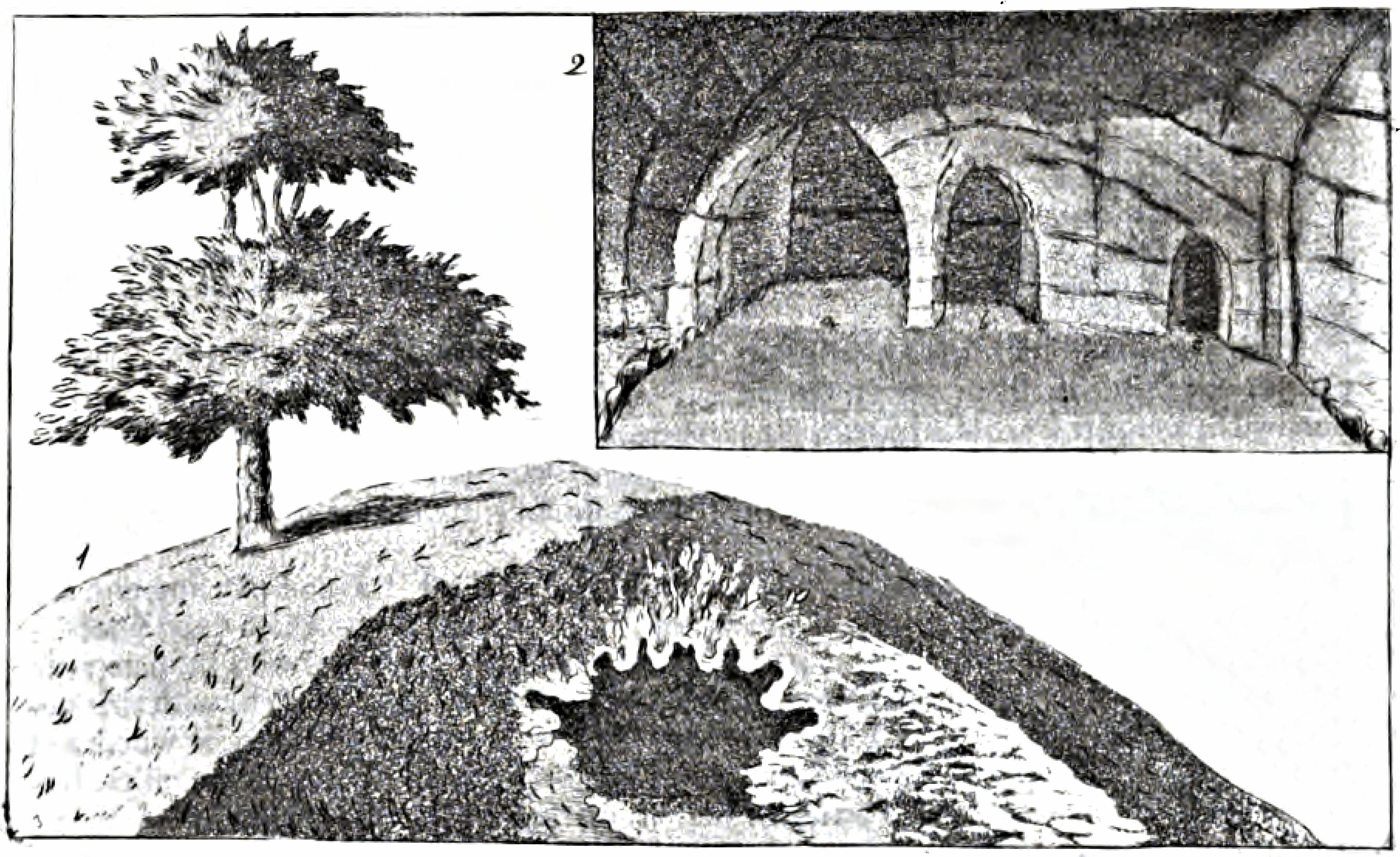
In this lordship is a hollow rock called Robin Hood's Stable, handed down, as such by tradition; it is a curious Cave on the side of a little hill, on a farm, om Mr. Montague's, near the Lodge at Papplewick-Hall. Hayman Rook, Esq. who favoured me with the drawings of the entrance and internal appearances of this Cave, from which the views below are taken, thinks there is a great probability of its being used by that celebrated depredator.
No. 1, is a perspective view of the entrance before the present door was put up and the wall erected.
No. 2, is a view of the inside. This Cave evidently appears to have been cut out of the solid rock, which seems to have been excavated with judgement; the little hollows (a) (b) (c), are well contrived for holding fodder; at (a) two horses may feed together; at (b) and (c) one each.[2]

Gazetteers
- Dobson, R. B., ed.; Taylor, J., ed. Rymes of Robyn Hood: an Introduction to the English Outlaw (London, 1976), p. 303, s.n. 'Robin Hood's Stable'.
Sources
- Gover, J.E.B.; Mawer, Allen; Stenton, F.M. The Place-Names of Nottinghamshire (English Place-Name Society, vol. XVII) (Cambridge, 1940), pp. 131, 294.
Maps
Notes
- ↑ Dobson, R. B., ed.; Taylor, J., ed. Rymes of Robyn Hood: an Introduction to the English Outlaw (London, 1976), p. 303, s.n. 'Robin Hood's Stable'; Gover, J.E.B.; Mawer, Allen; Stenton, F.M. The Place-Names of Nottinghamshire (English Place-Name Society, vol. XVII) (Cambridge, 1940), pp. 131, 294.
- ↑ Thoroton, Robert. The Antiquities of Nottinghamshire: Extracted out of Records, Original Evidences, Leiger-books, Other Manuscripts, and Authentic Authorities. Beautified with Maps, Prospects, and Portraitures. 2nd ed. (Nottingham, 1790), vol. II, p. 287.

