Robin Hood's Park (Fountains Earth)
| Locality | |
|---|---|
| Coordinate | 54.114227, -1.778852 |
| Adm. div. | West Riding of Yorkshire |
| Vicinity | Near Gouthwaite Reservoir in Nidderdale |
| Type | Area |
| Interest | Robin Hood name |
| Status | Extant |
| First Record | 1853 |

By Henrik Thiil Nielsen, 2013-07-21. Revised by Henrik Thiil Nielsen, 2022-04-22.
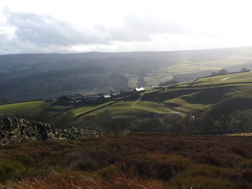
Dobson & Taylor thought 'Robin Hood's Park' was a "name apparently applied to part of an estate near Fountains Abbey",[1] four miles SW of Ripon. In this they have been followed by at least one of the better Robin Hood websites.[2] However, the place-name is listed by A. H. Smith under the township of Fountains Earth[3] which is not adjacent to Fountains Abbey. Located in Nidderdale, it owes its name to the fact that it (or most of the land within it) was owned by Fountains Abbey. Robin Hood's Park is an area c. 1 km east of (and above) the southern end of Gouthwaite Reservoir, close to a listed building called Sigsworth Grange, which in pre-Reformation times was a cattle lodge belonging to Fountains Abbey.[4]
Adding to the confusion over the location caused by the element 'Fountains' in both names is the fact that both the Robin Hood's Wood adjacent to Fountains Abbey and Robin Hood's Park in Fountains Earth were located next to a Robin Hood's Well. Robin Hood's Park is c. 12.5 km west of the Abbey as the crow flies. According to Grainge,[5] Robin Hood's Park was an area with many rocks. Most of them must have been used in constructing Gouthwaite Reservoir (1893-1910), but an area just below and to the SW of Robin Hood's Park and immediately east of and above Yates Wood still appears strewn with rocks; this can be seen in the Google Earth satelllite view in the image gallery below (click the photo for a larger view). White dots in the landscape in uphill areas are often fleece-clad herbivores, but the white spots here really do look like stones. In or just outside Yates Wood was the Robin Hood's Well mentioned in the verse cited below.
Robin Hood's Park was not an "enclosed tract of land held by royal grant or prescription for keeping beasts of the chase"[6], neither can it have been a park in the sense of an ornamental park, something we tend to connect with mansions, towns or cities. The locality to which the name was applied was not a wood but a field situated in a pastoral area, so the signification of 'park' is here that of an "enclosed piece of ground for pasture or tillage; a field; a parrock or paddock", a sense in evidence from 1581 to 1899 and used mainly in Ireland, Scotland, and the north of England.[7]
Macquoid in the allusion from 1883 cited below mentions the park and well near Sigsworth Grange but does not quote the verse cited in the 1863 allusion or add anything of substance to the passage in Grainge.[8] Note that the verse quoted in the 1863 Allusion is said elsewhere to have been written by Walter Scott for use as an inscription for Robin Hood's Well at Fountains Abbey. Evidently Dobson and Taylor were not the first writers to confuse Fountains Earth with the grounds of Fountains Abbey. 'Doubergill' cited below is now Dauber Gill.
The earliest source I have found for this place-name is the O.S. 6" map of the area published in 1853 (see Maps section below). It is not included in the 1838 tithe award for Fountains Earth.[9] Robin Hood's Park is still included on O.S. online maps,[10] which I take as an indication that the name is still in use.
Allusions
1863 - Grainge, William - Nidderdale
Sigsworth Grange is the last of the monastic farms, and was valued at the dissolution at 100s. per annum. It is situated on a ridge of land overlooking the rugged, wild wood clad glen of Doubergill, also commanding a fine view of the valley towards Bewerley and Guy's-cliffe. The present house and buildings are all modern; in an enclosure a short distance to the westward are traces of the foundation of a building which appears to have been composed of large stones; a great part of which has been removed for the purpose of forming fence walls. A field adjoining, full of native rocks, bears the name of "Robin Hood's Park." A spring of pure water in the wood below, is called "Robin Hood's Well." How singular to find the renowned outlaw's name asociated with places so remote from his general haunts; but as he loved to chase the deer of the monks as well as those of the king, he certainly might enjoy that sport in Nidderdale, where deer were plentiful at a much later period than that in which he lived. It is also pleasing to contemplate the outlaw quenching his thirst at this rock-born fountain.
Beside this crystal fount of old,
Cool'd his flush'd brow — an outlaw bold;
His bow was slackened while he drank,
His quiver rested on the bank,
Giving brief pause of doubt and fear,
To feudal lords and forest deer: —
Long since the date, but village sires,
Still sing his feats by Christmas fires;
And still old England's free born mood,
Stirs at the name of Robin Hood."[11]
1883 - Macquoid, Thomas - About Yorkshire
There are several wild glens [on the hill above the village of Lofthouse] which well reward the explorer; Wath woods and waterfalls near Pateley Bridge on the Doubergill beck, near which we found a trace of Robin Hood ; a rocky field not far from Sigsworth Grange is called Robin Hood's Park, and a spring in the wood below Robin Hood's Well.[12]
Gazetteers
Sources
- Grainge, William. Nidderdale; or, An Historical, Topographical, and Descriptive Sketch of the Valley of the Nidd, including Pateley Bridge, Bishopside, Dacre Banks, Hartwith, Brimham Rocks, Stonebeck Down, Ramsgill, Stonebeck up, Middlesmoor, Fountains Earth, Greenhow Hill, and the Stump Cross Caverns (Pateley Bridge and London, 1863), p. 185.
- Macquoid, Thomas; Macquoid, Katharine. About Yorkshire (London, 1894), p. 143.
- Smith, A.H. The Place-Names of the West Riding of Yorkshire (English Place-Name Society, vols. XXX-XXXVII) (Cambridge, 1961-63), pt. V, p. 205.
Maps
- 25" O.S. map Yorkshire CXVII.11 (1891; surveyed 1890)
- 25" O.S. map Yorkshire CXVII.11 (1909; rev. 1907) (georeferenced)
- 25" O.S. map Yorkshire CXVII.11 (1909; rev. 1907)
- 6" O.S. map Yorkshire 117 (1853; surveyed 1849-50)
- 6" O.S. map Yorkshire CXVII (1896; surveyed 1890)
- 6" O.S. map Yorkshire CXVII.SE (1910; rev. 1907-1908) (georeferenced)
- 6" O.S. map Yorkshire CXVII.SE (1910; surveyed 1907-1908)
- 1:25,000 O.S. Map SE16 (1952)
- Geograph Map: Grid Reference SE140684.
Background
- British Listed Buildings: Sigsworth Grange and Attached Barn, Fountains Earth
- Midgley Webpages
- Platt, Colin. The Monastic Grange in Medieval England: a Reassessment (New York, 1969), pp. 74, 102 n. 1, 109, 190
- Wikipedia: Gouthwaite Reservoir.
Also see
- Fountains Earth place-name cluster
- 1832 - Scott, Walter - Inscription for Robin Hood's Well
- Fountains Abbey (Ripon).
Notes
- ↑ Dobson, R. B., ed.; Taylor, J., ed. Rymes of Robyn Hood: an Introduction to the English Outlaw (London, 1976), p. 309.
- ↑ For instance Midgley Webpages.
- ↑ Smith, A.H. The Place-Names of the West Riding of Yorkshire (English Place-Name Society, vols. XXX-XXXVII) (Cambridge, 1961-63), pt. V, p. 205.
- ↑ For the Nidderdale cattle lodges of Fountains Abbey see Platt, Colin. The Monastic Grange in Medieval England: a Reassessment (New York, 1969), pp. 74, 102 n. 1, 109.
- ↑ Grainge, William. Nidderdale; or, An Historical, Topographical, and Descriptive Sketch of the Valley of the Nidd, including Pateley Bridge, Bishopside, Dacre Banks, Hartwith, Brimham Rocks, Stonebeck Down, Ramsgill, Stonebeck up, Middlesmoor, Fountains Earth, Greenhow Hill, and the Stump Cross Caverns (Pateley Bridge and London, 1863), p. 185.
- ↑ OED2, s.n. park, n., 1.a. (c1260-1818)
- ↑ OED2. s.n. park, n., 3.a.
- ↑ Grainge. loc. cit..
- ↑ See tithe award at The Genealogist, Piece 043, sub-piece 162 (£).
- ↑ Geograph Map: Grid Reference SE140684.
- ↑ Grainge, William. Nidderdale; or, An Historical, Topographical, and Descriptive Sketch of the Valley of the Nidd, including Pateley Bridge, Bishopside, Dacre Banks, Hartwith, Brimham Rocks, Stonebeck Down, Ramsgill, Stonebeck up, Middlesmoor, Fountains Earth, Greenhow Hill, and the Stump Cross Caverns (Pateley Bridge and London, 1863), p. 185.
- ↑ Macquoid, Thomas; Macquoid, Katharine. About Yorkshire (London, 1894), p. 143.
Image gallery
Click any image to display it in the lightbox, where you can navigate between images by clicking in the right or left side of the current image.
The area known as 'Robin Hood's Park' lies just behind Sigsworth Grange which is seen in this photo / Matt O'Brien, 28 Mar. 2015.


