
Robin Hood's Cave (Creswell Crags): Difference between revisions
(Created page with "__NOTOC__{{PlaceNamesItemTop|Lat=53.262053|Lon=-1.200398|AdministrativeDivision=Derbyshire|Vicinity=SE of Creswell village; on N side of Crags Road, ''c.'' 530 m ENE of Mansfi...") |
mNo edit summary |
||
| Line 1: | Line 1: | ||
__NOTOC__{{PlaceNamesItemTop|Lat=53.262053|Lon=-1.200398|AdministrativeDivision=Derbyshire|Vicinity= | __NOTOC__{{PlaceNamesItemTop|Lat=53.262053|Lon=-1.200398|AdministrativeDivision=Derbyshire|Vicinity=E of Creswell village; on N side of Crags Road, ''c.'' 530 m ENE of Mansfield Road (A616)|Type=Natural feature|Interest=Robin Hood name| | ||
Status=Extant|Demonym=|Riding=|GreaterLondon=|Year=<!--Four digits-->|Aka=Robin Hood Cave|Century=|Cluster1=|Cluster2=|Cluster3=|Image= | Status=Extant|Demonym=|Riding=|GreaterLondon=|Year=<!--Four digits-->|Aka=Robin Hood Cave|Century=|Cluster1=|Cluster2=|Cluster3=|Image=geograph-2749519-by-Richard-Croft.jpg|Postcards=|ExtraCat1=|ExtraCat2=|ExtraCat3=|ExtraCat4=|ExtraCat5=|ExtraLink1=|ExtraLink2=|ExtraLink3=|ExtraLink4=|ExtraLink5=|ExtraLinkName1=|ExtraLinkName2=|ExtraLinkName3=|ExtraLinkName4=|ExtraLinkName5=|GeopointPrefix=|GeopointSuffix=|VicinitySuffix=|StatusSuffix=|DatePrefix=|DateSuffix=}} | ||
{{#display_map:{{#var:Coords}}~{{#replace:{{PAGENAME}}|'|'}}|width=34%|fullscreen=yes}}<div class="pnMapLegend">{{PAGENAME}}.</div> | {{#display_map:{{#var:Coords}}~{{#replace:{{PAGENAME}}|'|'}}|width=34%|fullscreen=yes}}<div class="pnMapLegend">{{PAGENAME}}.</div> | ||
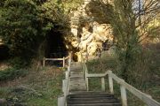
[[File:{{#var:Image}}|thumb|right|500px| | [[File:{{#var:Image}}|thumb|right|500px|Robin Hood's Cave / [https://m.geograph.org.uk/photo/2749519 Richard Croft, 2 Jan. 2012; Creative Commons, via Geograph.]]] | ||
<div class="no-img"><p id="byline">By | <div class="no-img"><p id="byline">By Henrik Thiil Nielsen, 2022-04-25. Revised by {{#realname:{{REVISIONUSER}}}}, {{REVISIONYEAR}}-{{REVISIONMONTH}}-{{REVISIONDAY2}}.</p> | ||
Robin Hood's Cave is the usual name of one of the caves at Creswell Crags, slightly south-east of Creswell village, on the north side of Crags Road. The cave is located ''c.'' 530 m east-northeast of Mansfield Road (A616). | Robin Hood's Cave is the usual name of one of the caves at Creswell Crags, slightly south-east of Creswell village, on the north side of Crags Road. The cave is located ''c.'' 530 m east-northeast of Mansfield Road (A616). It is not clear when the name 'Robin Hood's Cave' came into use, but it is found on an O.S. map of the area published in 1884. | ||
Creswell Crags are a low, west–east-oriented gorge cutting through a Lower Permian limestone ridge that extends from southern Yorkshire to northern Leicestershire. Administratively belonging in Derbyshire, the Crags straddle the present border between Derbyshire and Nottinghamshire. Individually named natural features at the Crags include the following caves: | |||
* The Pin Hole Cave | |||
* Robin Hood's Cave | |||
* Church Hole, | |||
and rock-shelters: | |||
* The West End Shelters | |||
* The Holly Shelter | |||
* Mother Grundy's Parlour | |||
* The Boat House. | |||
All the caves and Mother Grundy's Parlour contain prehistoric artefacts and other evidence of human use from the middle palaeolithic to the 19th century.<ref>{{:Campbell, J B 1969a}}, see pp. 47–48.</ref> | |||
{{PlaceNamesItemAllusionsAndRecords}} | {{PlaceNamesItemAllusionsAndRecords}} | ||
== Gazetteers == | == Gazetteers == | ||
| Line 37: | Line 51: | ||
</div> | </div> | ||
{{ImageGalleryIntroduction}} | {{ImageGalleryIntroduction}} | ||
<gallery widths="195px"> | <gallery widths="195px"> | ||
geograph-2749519-by-Richard-Croft.jpg|Robin Hood's Cave / [https://m.geograph.org.uk/photo/2749519 Richard Croft, 2 Jan. 2012; Creative Commons, via Geograph.] | |||
</gallery | </gallery> | ||
{{PlaceNamesItemNavigation}} | {{PlaceNamesItemNavigation}} | ||
Revision as of 16:40, 25 April 2022
| Locality | |
|---|---|
| Coordinate | 53.262053, -1.200398 |
| Adm. div. | Derbyshire |
| Vicinity | E of Creswell village; on N side of Crags Road, c. 530 m ENE of Mansfield Road (A616) |
| Type | Natural feature |
| Interest | Robin Hood name |
| Status | Extant |
| First Record | |
| A.k.a. | Robin Hood Cave |

By Henrik Thiil Nielsen, 2022-04-25. Revised by Henrik Thiil Nielsen, 2022-04-25.
Robin Hood's Cave is the usual name of one of the caves at Creswell Crags, slightly south-east of Creswell village, on the north side of Crags Road. The cave is located c. 530 m east-northeast of Mansfield Road (A616). It is not clear when the name 'Robin Hood's Cave' came into use, but it is found on an O.S. map of the area published in 1884.
Creswell Crags are a low, west–east-oriented gorge cutting through a Lower Permian limestone ridge that extends from southern Yorkshire to northern Leicestershire. Administratively belonging in Derbyshire, the Crags straddle the present border between Derbyshire and Nottinghamshire. Individually named natural features at the Crags include the following caves:
- The Pin Hole Cave
- Robin Hood's Cave
- Church Hole,
and rock-shelters:
- The West End Shelters
- The Holly Shelter
- Mother Grundy's Parlour
- The Boat House.
All the caves and Mother Grundy's Parlour contain prehistoric artefacts and other evidence of human use from the middle palaeolithic to the 19th century.[1]
Allusions
1841 - Hall, Spencer Timothy - Forester's Offering (2)
Down on the confines of the county, near to Welbeck Park, are the romantic recesses of Cresswell [sic] Crags and Markland Grips, from which the Wollen winds into Welbeck Lake. These cavernous rocks, which are almost described by their own names, are little inferior in imposing grandeur to some parts of Matlock Dale; and the immortal name of the bold chieftain [sc. Robin Hood] is identified with them, as with all other natural strongholds in this and the approximate counties. Here are clefts—wide, grim, and deep—so deep that their extent is now unknown—the approaches to some of which are extremely difficult. One of them which, though not so extensive as some, is the most remarkable of all, I once explored myself. Its entrance is shaded by a pleasant bower of indigenous trees and shrubs, and the look-out from among these, down the valley, is truly delicious. After procuring a candle from one of the neighbouring cottages, and piercing the gloom for about a dozen yards, I came to a small aperture on the left, perhaps two feet in diameter, having crept through which, I found myself in a magnificent apartment, called Robin Hood's Hall, with walls beautifully coruscant, and so lofty that my light was too diminutive to reach the roof. Beyond this are several other extensive rooms, which, with the rustics in the vicinity, have from generation to generation borne the names of Robin Hood's Pantry, parlour, chamber, etc. In a recess in one of the rooms, is a spring of clear, cold water; and I should think this cave alone of sufficient magnitude to accomodate fifty outlaws, with plenty of room for six [p. 22:] months' stores, and every convenience for cooking and domestic recreation,—so that with a grey stone rolled against the entrance, which would have the appearance of a portion of the solid rock to any intruder from without—admitting any stranger bold enough to attempt an intrusion in such darkly-superstitiuous times—the whole band might winter here without the slightest fear of molestation from those who could have any evil disposition towards them.
Supposing, then, this rocky fortification to have been the winter retreat of Robin and his hardy band; imagining him to have drawn around him here, during his Christmas festivities amid scenes so strange and wild, the homeless, the world-weary, the bereaved, the persecuted, the outcast and the forlorn, of all denominations, and to have made them all nobles in his own free court; then imagining again the winter to have passed away, and spring to have filled the heavens with sunshine, the earth with verdure, and the heart of man and every living thing with hope and gladness; and then, O! then, when he sallied at length into the Forest, what a vast scene of magnificence, and majesty, and wonder, and beauty, must have awaited his buoyant, exultant out-stepping![2]
Gazetteers
- Not included in Dobson, R. B., ed.; Taylor, J., ed. Rymes of Robyn Hood: an Introduction to the English Outlaw (London, 1976), pp. 293-311.
Sources
- Brown J.; Lewis, B.; Sheppard, R. 'Fieldwork in Derbyshire by Trent & Peak Archaeological Unit in 2004–2006', Derbyshire Archaeological Journal, vol. 127 (2007), pp. 114-38
- Campbell, J B 1969a
- Wikipedia: Creswell Crags.
Maps
- 25" map Derbyshire XIX.16 (c. 1877; surveyed c. 1873). No copy in NLS
- 25" O.S. map Derbyshire XIX.16 (1898; rev. 1897) (georeferenced)
- 25" O.S. map Derbyshire XIX.16 (1898; rev. 1897)
- 25" O.S. map Derbyshire XIX.16 (1916; rev. 1914)
- 6" O.S. map Derbyshire XIX.SE (1884; surveyed 1875)
- 6" O.S. map Derbyshire XIX.SE (1886; surveyed 1875–84)
- 6" O.S. map Derbyshire XIX.SE (1899; rev. 1897) (georeferenced)
- 6" O.S. map Derbyshire XIX.SE (1899; rev. 1897)
- 6" O.S. map Derbyshire XIX (1923; rev. 1914)
- 6" O.S. map Derbyshire XIX.SE (1923; rev. 1914)
- 6" O.S. map Derbyshire XIX.SE (c. 1934; rev. 1914)
- 6" O.S. map Derbyshire XIX.SE (c. 1950; rev. 1947).
Discussion
Background
Notes
- ↑ Campbell, J B 1969a, see pp. 47–48.
- ↑ Hall, Spencer Timothy. The Forester's Offering (London, 1841), p. 21.
Image gallery
Click any image to display it in the lightbox, where you can navigate between images by clicking in the right or left side of the current image.
Robin Hood's Cave / Richard Croft, 2 Jan. 2012; Creative Commons, via Geograph.