
Robin Hood's Butt (Furze Hill): Difference between revisions
mNo edit summary |
mNo edit summary |
||
| Line 8: | Line 8: | ||
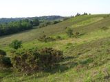
<!-- Mike Faherty photo: Ibsley Common, clump of trees. On the ridge overlooking Chibden and Brogenslade Bottoms; distinctive enough to be a landmark. --> | <!-- Mike Faherty photo: Ibsley Common, clump of trees. On the ridge overlooking Chibden and Brogenslade Bottoms; distinctive enough to be a landmark. --> | ||
<!-- Jim Champion photo: This footpath approaches Robin Hood's Clump from South Gorley along a spur of the Ibsley Common plateau. The pine trees in the clump were planted by Lord Normanton in 1931 to replace the previous trees that were destroyed by a heath fire. Beneath the trees is a Bronze Age disc barrow. --> | <!-- Jim Champion photo: This footpath approaches Robin Hood's Clump from South Gorley along a spur of the Ibsley Common plateau. The pine trees in the clump were planted by Lord Normanton in 1931 to replace the previous trees that were destroyed by a heath fire. Beneath the trees is a Bronze Age disc barrow. --> | ||
<!-- | |||
If you have any comments or new information about this record, please email us. | |||
NT HBSMR Number: 123290 | |||
Type of Record: Landscape | |||
Name: Robin Hood's Clump, Ibsley Common, Ibsley and Rockford Commons | |||
Summary | |||
Robin Hood's Clump, Ibsley Common, New Forest (HFCAS Section Site no. SU11SE39) NF10177 | |||
Grid Reference: SU 171 106 | |||
Civil Parish: Ellingham; Harbridge and Ibsley; New Forest; Hampshire | |||
County: Hampshire | |||
NT Property: Ibsley and Rockford Commons; London and South East | |||
Map: All our Monument records are mapped in NT Heritage Records Online. | |||
Protected Status | |||
Scheduled Monument 1019305: ROUND BARROW CEMETERY ON IBSLEY COMMON, 800M SOUTH EAST OF BLUNTS BARN COTTAGE | |||
Other References/Statuses | |||
Common Land: Ibsley Common | |||
National Park: New Forest | |||
Monument Types | |||
CIRCULAR ENCLOSURE (Prehistoric - 500000 BC to 42 AD) | |||
Full description | |||
Robin Hood's Clump is a landmark feature visible for miles around. It comprises a group of eighteen fairly small Scots pine (said to have been replanted in 1931 and much smaller than the overstorey in Whitefield Clump) in a prominent hilltop position. They are planted within a circular embanked enclosure, with the interior slightly raised above the surroundings, and with an external ditch which presumably provided the material for raising the interior in addition to the bank construction. The diameter (top of bank to top of bank) is 10.3 metres and the overall diameter including the ditch is 15 metres. The top of the bank is about 0.4 metres above the bottom of the ditch. It is thus very similar in form (if not in size) to the hilltop planting rings at Paddy Bussey's Firs (Map 14) on Rockford Common and the ring earthwork at Dorridge (Map 12). It is also comparable to the three planting rings on Pleasure House Hill in Newlands (Map 1), although far more consolidated, perhaps because of its exposed position open to stock and heavily trampled by walkers. Unfortunately, this straightforward identification of a planting ring is challenged by English Heritage who have determined that it is in fact a barrow and who have scheduled it under the number SM31178/02. They further comment on it as follows: | |||
"The disc barrow, 19.5m in total diameter (conflicts with our measurement) is of relatively unusual form, comprising a disc shaped platform, raised 0.15m, surrounded by a low raised rim, and a shallow outer ditch. It is very prominently located at the intersection of two spurs at the western edge of the gravel plateau". | |||
Since this is probably the most prominent archaeological feature on Ibsley Common, it is worth considering in more detail the two possible interpretations of the earthwork. Against this being a barrow is one important piece of negative evidence. The first edition of the Ordance Survey One Ince map shows many of the more obvious barrows on Ibsley Common by the standard cicular symbol. It shows the "cockpit" barrow (Site SU11SE40) which is only 150 metres away and much less obvious than Robin Hood's Clump. If the latter existed as an earthwork (supposed barrow) in 1808, why was it omitted? We have been unable to arrive at any precise dating of the ornamental clump planting on Ibsley Common, but Sumner's record in the "Book of Gorley"(2) is as follows: | |||
"The three clumps of Scots pine and Weymouth pine (sic) - Whitefield, Robin Hood's and Dorridge - were planted by the second Lord Normanton to give landmarks and variety to his view from Somerley of the long line of the New Forest hills, so the story is told. Whitefield and Dorridge were planted about the year 1835, Robin Hood's about the year 1850". | |||
The Dorridge Clump referred to here had been planted by 1840. It is almost certainly the enclosure on Dorridge Hill now occupied by the bungalow of that name and not the "ring" further north east. Whitefield is on an altogether larger scale. The Ibsley tithe map of 1841 shows neither Whitefield nor Robin Hood's clumps but both appear on the OS 6" map of 1872(3). | |||
A typescript in the New Forest Museum at Lyndhurst, "Notes on Hyde and Frogham" by M. Cowie (1951) contains the following: "It is still remembered how the Dowager Lady Normanton of Victorian times used to drive over from Somerley in her coach and pair, in the afternoons, to a view point on Furzehill where she had planted a ring of trees beneath which she sat to admire the views and distant prospect of Somerley House." This could hardly be any other site than Robin Hood's Clump which might reasonably be described as "on Furzehill". | |||
In support of the barrow theory, it should be noted that the place name "Robin Hood's Butt" appears on the Ordance Survey map (misplaced [presumably] to the west). "Butt" placenames in the New Forest are often attached to barrows, e.g. "The Butt" at Fritham and "The Butts" near Islands Thorns. | |||
Finally, the possibility that both interpretations of the earthwork might be correct cannot be overlooked. It is possible that the clump was planted on a pre-existing barrow site. Certainly there is some evidence to suggest that this was done at Three Trees Hill on Rockford Common (Site SU10NE35).(1) | |||
A 12m x 0.5m Bronze Age burial mound. Visible as a low cicrcular platform with a small copse of trees planted on it. (4) | |||
Sources / Further Reading | |||
--- SNA67960 - Measured Survey: New Forest National Park Authority. New Forest National Park Survey Avon Valley Commons, Ibsley and Rockford, New Forest. | |||
[1]XY SNA65740 - Report: Hampshire Field. August 2000. New Forest Commons of The National Trust, An Archaeological and Landscape Assessment, Volume II - The Avon Valley Commons. [Mapped features: #116100 Point Location, ; #159276 A 12m x 0.5m Bronze Age burial mound. Visible as a low cicrcular platform with a small copse of trees planted on it., ] | |||
[2] SNA65794 - Document: H. Sumner. 1910. "The Book of Gorley". | |||
[3] SAA56 - Map: Ordnance Survey. 1872. Ordnance Survey Map. Uncertain. First. | |||
Associated Finds: none recorded | |||
Associated Events: none recorded | |||
Related records: none recorded | |||
Images | |||
--> | |||
{{PlaceNamesItemAllusionsAndRecords}} | {{PlaceNamesItemAllusionsAndRecords}} | ||
Revision as of 19:19, 5 May 2022
| Locality | |
|---|---|
| Coordinate | 50.894946, -1.757353 |
| Adm. div. | Hampshire |
| Vicinity | Ibsley Common, New Forest; near Furze Hill; c. 1 km SE of North Gorley; c. 1 km NE of South Gorley |
| Type | Natural feature |
| Interest | Robin Hood name |
| Status | Extant |
| First Record | 1872 |

By Henrik Thiil Nielsen, 2022-05-05. Revised by Henrik Thiil Nielsen, 2022-05-05.
Allusions
1910 - Sumner, Heywood - Book of Gorley
The three clumps of Scots fir & Weymouth pine – Whitefield[,] Robin Hood's, & Dorridge – were planted by the 2nd Lord Normanton to give landmarks & variety to his view of the long line of the New Forest Hills from Somerley – so the story is told – Whitefield & Dorridge were planted about 1835 – Robin Hood's about 1850 – Dorridge is the highest ground on the common – 257 feet above the sea level – while the lowest part is at the caltle [sic, for 'cattle'] stop, where the Huckles brook leaves the common – 100 feet above the sea level.[1]
Gazetteers
- Not included in Dobson, R. B., ed.; Taylor, J., ed. Rymes of Robyn Hood: an Introduction to the English Outlaw (London, 1976), pp. 293-311.
Sources
- Heritage Gateway: National Trust HBSMR 123290: Robin Hood's Clump, Ibsley Common, Ibsley and Rockford Commons
- National Trust: Heritage Records: Robin Hood's Clump, Ibsley Common, Ibsley and Rockford Commons.
Maps
- 25" map Hampshire and Isle of Wight LXII.12 (c. 1875; surveyed 1870). No copy in NLS
- 25" O.S. map Hampshire and Isle of Wight LXII.12 (1897; rev. 1895) (georeferenced)
- 25" O.S. map Hampshire and Isle of Wight LXII.12 (1897; rev. 1895)
- 25" O.S. map Hampshire and Isle of Wight LXII.12 (1909; rev. 1907)
- 25" O.S. map Hampshire and Isle of Wight LXII.12 (1946; rev. 1940)
- 6" O.S. map Hampshire & Isle of Wight LXII (1872; surveyed 1870–71)
- 6" O.S. map Hampshire & Isle of Wight LXII.SE (1898; rev. 1895) (georeferenced)
- 6" O.S. map Hampshire & Isle of Wight LXII.SE (1898; rev. 1895)
- 6" O.S. map Hampshire & Isle of Wight LXII.SE (1910; rev. 1907).
Also see
Notes
Image gallery
Click any image to display it in the lightbox, where you can navigate between images by clicking in the right or left side of the current image.

Robin Hood's Butt or Clump / Mike Faherty, 1 Apr. 2012; Creative Commons, via Geograph.

Approaching Robin Hood's Clump, Ibsley Common, New Forest / Jim Champion, 10 June 2006; Creative Commons, via Geograph.
The view from Robin Hood's Butt, New Forest / Jim Champion, 10 June 2006; Creative Commons, via Geograph.

