
Dipping Stone (Whaley Moor)
From International Robin Hood Bibliography
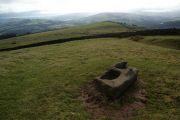
The Dipping Stone, Whaley Moor.
[[File:|thumb|right|500px|The Dipping Stone / Graham Hogg, 22 Sep. 2015, Creative Commons via Geograph.]]
By Henrik Thiil Nielsen, 2019-02-21. Revised by Henrik Thiil Nielsen, 2019-02-21.
_TEXT_ Template:PnItemQry
Gazetteers
- Not included in Dobson, R. B., ed.; Taylor, J., ed. Rymes of Robyn Hood: an Introduction to the English Outlaw (London, 1976), pp. 293-311.
Maps
- 6" O.S. map Cheshire XXIX (1881; surveyed 1870-71)
- 6" O.S. map Cheshire XXIX.NE (1899; rev. 1896) (georeferenced).
- 6" O.S. map Cheshire XXIX.NE (1899; rev. 1896)
- 6" O.S. map Cheshire XXIX.NE (1913; rev. 1907)
- 6" O.S. map Derbyshire VIII (1924; rev. 1919-20)
- 25" O.S. map Cheshire XXIX.3 (c. 1873; c. 1870). No Copy in NLS
- 25" O.S. map Cheshire XXIX.3 (1897; rev. 1896)
- 25" O.S. map Cheshire XXIX.3 (1909; rev. 1907).
- 25" O.S. map Cheshire XXIX.3 (1897; rev. 1896) (georeferenced)]
Background
- Historic England: Wayside and boundary cross known as The Dipping Stone
- Megalithic Portal: The Dipping Stone – Ancient Cross in England in Derbyshire
- PastScape: Dipping Stone.

The Dipping Stone / Graham Hogg, 22 Sep. 2015, Creative Commons via Geograph.
The Dipping Stone / Bill Boaden, 21 Feb. 2012, Creative Commons via Geograph.

The Dipping Stone / Chris Morgen, 22 Sep. 2015, Creative Commons via Geograph.
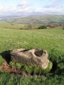
The Dipping Stone / Dave Dunford, 12 Nov. 2005, Creative Commons via Geograph.


