
Dipping Stone (Whaley Moor): Difference between revisions
mNo edit summary |
m (Text replacement - "{{#display_map:{{#var:Coords}}~{{#replace:{{PAGENAME}}|'|'}}|width=34%}}<div class="pnMapLegend">" to "{{#display_map:{{#var:Coords}}~{{#replace:{{PAGENAME}}|'|'}}|width=34%|service=leaflet}}<div class="pnMapLegend">") |
||
| Line 1: | Line 1: | ||
__NOTOC__{{PnItemTop|Lat=53.332301|Lon=-2.008219|AdmDiv=Cheshire|Vicinity=''c.'' 750 m W of Whaley Bridge|Type=Monument|Interest=Local tradition| | __NOTOC__{{PnItemTop|Lat=53.332301|Lon=-2.008219|AdmDiv=Cheshire|Vicinity=''c.'' 750 m W of Whaley Bridge|Type=Monument|Interest=Local tradition| | ||
Status=Defunct|Demonym=|Riding=|GreaterLondon=|Year=1810|Aka=Plague Stone; Robin Hood's Picking Stone; Robin Hood's Stone|Century=|Cluster1=High Peak|Cluster2=|Cluster3=|Image=geograph-4673380-by-Graham-Hogg.jpg|Postcards=|ExtraCat1=Places connected by bowshot|ExtraCat2=|ExtraCat3=|ExtraCat4=|ExtraCat5=|ExtraLink1=Robin Hood's Bow Stones (Lyme Handley)|ExtraLink2=Chinley Churn (Chinley)|ExtraLink3=|ExtraLink4=|ExtraLink5=|ExtraLinkName1=|ExtraLinkName2=|ExtraLinkName3=|ExtraLinkName4=|ExtraLinkName5=|GeopointPrefix=|GeopointSuffix=|VicinitySuffix=|StatusSuffix=|DatePrefix=|DateSuffix=}} | Status=Defunct|Demonym=|Riding=|GreaterLondon=|Year=1810|Aka=Plague Stone; Robin Hood's Picking Stone; Robin Hood's Stone|Century=|Cluster1=High Peak|Cluster2=|Cluster3=|Image=geograph-4673380-by-Graham-Hogg.jpg|Postcards=|ExtraCat1=Places connected by bowshot|ExtraCat2=|ExtraCat3=|ExtraCat4=|ExtraCat5=|ExtraLink1=Robin Hood's Bow Stones (Lyme Handley)|ExtraLink2=Chinley Churn (Chinley)|ExtraLink3=|ExtraLink4=|ExtraLink5=|ExtraLinkName1=|ExtraLinkName2=|ExtraLinkName3=|ExtraLinkName4=|ExtraLinkName5=|GeopointPrefix=|GeopointSuffix=|VicinitySuffix=|StatusSuffix=|DatePrefix=|DateSuffix=}} | ||
{{#display_map:{{#var:Coords}}~{{#replace:{{PAGENAME}}|'|'}}|width=34%}}<div class="pnMapLegend">The Dipping Stone, Whaley Moor.</div> | {{#display_map:{{#var:Coords}}~{{#replace:{{PAGENAME}}|'|'}}|width=34%|service=leaflet}}<div class="pnMapLegend">The Dipping Stone, Whaley Moor.</div> | ||
[[File:{{#var:Pnimage}}|thumb|right|500px|The Dipping Stone / [https://www.geograph.org.uk/photo/4673380 Graham Hogg, 22 Sep. 2015, Creative Commons via Geograph.]]] | [[File:{{#var:Pnimage}}|thumb|right|500px|The Dipping Stone / [https://www.geograph.org.uk/photo/4673380 Graham Hogg, 22 Sep. 2015, Creative Commons via Geograph.]]] | ||
<p id="byline">By Henrik Thiil Nielsen, 2019-02-21. Revised by {{#realname:{{REVISIONUSER}}}}, {{REVISIONYEAR}}-{{REVISIONMONTH}}-{{REVISIONDAY2}}.</p><div class="no-img"> | <p id="byline">By Henrik Thiil Nielsen, 2019-02-21. Revised by {{#realname:{{REVISIONUSER}}}}, {{REVISIONYEAR}}-{{REVISIONMONTH}}-{{REVISIONDAY2}}.</p><div class="no-img"> | ||
Revision as of 08:55, 5 April 2019
[[File:|thumb|right|500px|The Dipping Stone / Graham Hogg, 22 Sep. 2015, Creative Commons via Geograph.]]
By Henrik Thiil Nielsen, 2019-02-21. Revised by Henrik Thiil Nielsen, 2019-04-05.
In the early 19th century, there was a tradition in the High Peak to the effect that Robin Hood had shot an arrow from the Bowstones near Lyme Handley to the Dipping Stone at Whaley Moor, and from there to Chinley Churn.
Wiliam Marriott discusses these traditions at length in his Antiquities of Lyme and its Vicinity, published in 1810 (see Allusions below). He notes that the folk names of 'Robin Hood's Picking Stone' and 'Robin Hood's Stone' were used of several stone monuments, but it is not entirely clear if the Dipping Stone was one of these.
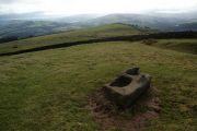
Situated on the crest of a shallow ridge below the southern end of Whaley Moor, just off a footpath leading from Whaley Lane to Hawkshurt Head, the Dipping Stone is the rectangular, c. 120 cm long and c. 50 to 80 cm wide base stone of a pair of Saxon crosses, dated no later than the 10th century. Similar base stones are part of the Bowstones, Robin Hood's Picking Rods and the Great Stone at Stretford (Lancs). This group of crosses may have been boundary marks of either ecclesiastical divisions or English and Danish Districts. The Dipping Stone is a scheduled monument.[1]
For the alleged connection between this monument and others in the High Peak, see High Peak place-name cluster. Template:PnItemQry
Gazetteers
- Not included in Dobson, R. B., ed.; Taylor, J., ed. Rymes of Robyn Hood: an Introduction to the English Outlaw (London, 1976), pp. 293-311.
Sources
- Marriott, William. The Antiquities of Lyme and its Vicinity (Stockport, 1810), pp. 4-5, 18-27, 51-53, 346-60, and passim.
Maps
- 6" O.S. map Cheshire XXIX (1881; surveyed 1870-71)
- 6" O.S. map Cheshire XXIX.NE (1899; rev. 1896) (georeferenced).
- 6" O.S. map Cheshire XXIX.NE (1899; rev. 1896)
- 6" O.S. map Cheshire XXIX.NE (1913; rev. 1907)
- 6" O.S. map Derbyshire VIII (1924; rev. 1919-20)
- 25" O.S. map Cheshire XXIX.3 (c. 1873; c. 1870). No Copy in NLS
- 25" O.S. map Cheshire XXIX.3 (1897; rev. 1896)
- 25" O.S. map Cheshire XXIX.3 (1909; rev. 1907)
- 25" O.S. map Cheshire XXIX.3 (1897; rev. 1896) (georeferenced).
Background
- Biden, H. B. 'The Stretford Stone and its Kindred', The South Manchester Gazette (27 June 1885), p. ?; not seen
- Cox, J. Charles. 'Early Crosses in the High Peak', The Athenæum, No. 4002 (9 July 1904), pp. 56-58; see p. 57
- Green, Charles. 'Some Stone Monuments near Manchester', Transactions of the Lancashire and Cheshire Antiquarian Society, vol. 56 (1944), pp. 114-120; not seen
- Historic England: Wayside and boundary cross known as The Dipping Stone
- Megalithic Portal: The Dipping Stone – Ancient Cross in England in Derbyshire
- PastScape: Dipping Stone
- Phillips, C. W. 'Some Stone Monuments', Antiquity, vol. XI (1937), pp. 294-99
Notes

The Dipping Stone / Graham Hogg, 22 Sep. 2015, Creative Commons via Geograph.
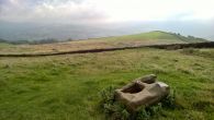
The Dipping Stone / Bill Boaden, 21 Feb. 2012, Creative Commons via Geograph.
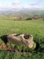
The Dipping Stone / Chris Morgen, 22 Sep. 2015, Creative Commons via Geograph.
The Dipping Stone / Dave Dunford, 12 Nov. 2005, Creative Commons via Geograph.
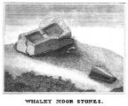
The Dipping Stone / Marriott, William. Antiquities of Lyme and its Vicinity (1810), plate facing p. 2.


.jpg)