
Dipping Stone (Whaley Moor): Difference between revisions
mNo edit summary |
mNo edit summary |
||
| Line 4: | Line 4: | ||
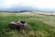
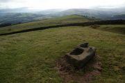
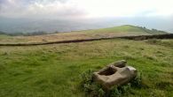
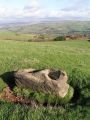
[[File:{{#var:Pnimage}}|thumb|right|500px|The Dipping Stone / [https://www.geograph.org.uk/photo/4673380 Graham Hogg, 22 Sep. 2015, Creative Commons via Geograph.]]] | [[File:{{#var:Pnimage}}|thumb|right|500px|The Dipping Stone / [https://www.geograph.org.uk/photo/4673380 Graham Hogg, 22 Sep. 2015, Creative Commons via Geograph.]]] | ||
<p id="byline">By Henrik Thiil Nielsen, 2019-02-21. Revised by {{#realname:{{REVISIONUSER}}}}, {{REVISIONYEAR}}-{{REVISIONMONTH}}-{{REVISIONDAY2}}.</p><div class="no-img"> | <p id="byline">By Henrik Thiil Nielsen, 2019-02-21. Revised by {{#realname:{{REVISIONUSER}}}}, {{REVISIONYEAR}}-{{REVISIONMONTH}}-{{REVISIONDAY2}}.</p><div class="no-img"> | ||
In the early 19th century, there was a tradition in the High Peak to the effect that Robin Hood had shot an arrow from [[Robin Hood's Bow Stones (Lyme Handley)|the Bowstones near Lyme Handley]] to the Dipping Stone at Whaley Moor, and from there to [[Chinley Churn (Derbyshire)|Chinley Churn]]. | |||
{{PnItemQry}} | {{PnItemQry}} | ||
== Gazetteers == | == Gazetteers == | ||
Revision as of 03:35, 21 February 2019
[[File:|thumb|right|500px|The Dipping Stone / Graham Hogg, 22 Sep. 2015, Creative Commons via Geograph.]]
By Henrik Thiil Nielsen, 2019-02-21. Revised by Henrik Thiil Nielsen, 2019-02-21.
In the early 19th century, there was a tradition in the High Peak to the effect that Robin Hood had shot an arrow from the Bowstones near Lyme Handley to the Dipping Stone at Whaley Moor, and from there to Chinley Churn. Template:PnItemQry
Gazetteers
- Not included in Dobson, R. B., ed.; Taylor, J., ed. Rymes of Robyn Hood: an Introduction to the English Outlaw (London, 1976), pp. 293-311.
Sources
- Marriott, William. The Antiquities of Lyme and its Vicinity (Stockport, 1810), pp. 4-5, 18-27, 51-53, 346-60, and passim.
Maps
- 6" O.S. map Cheshire XXIX (1881; surveyed 1870-71)
- 6" O.S. map Cheshire XXIX.NE (1899; rev. 1896) (georeferenced).
- 6" O.S. map Cheshire XXIX.NE (1899; rev. 1896)
- 6" O.S. map Cheshire XXIX.NE (1913; rev. 1907)
- 6" O.S. map Derbyshire VIII (1924; rev. 1919-20)
- 25" O.S. map Cheshire XXIX.3 (c. 1873; c. 1870). No Copy in NLS
- 25" O.S. map Cheshire XXIX.3 (1897; rev. 1896)
- 25" O.S. map Cheshire XXIX.3 (1909; rev. 1907).
- 25" O.S. map Cheshire XXIX.3 (1897; rev. 1896) (georeferenced)]
Background
- Historic England: Wayside and boundary cross known as The Dipping Stone
- Megalithic Portal: The Dipping Stone – Ancient Cross in England in Derbyshire
- PastScape: Dipping Stone.
Notes
The Dipping Stone / Graham Hogg, 22 Sep. 2015, Creative Commons via Geograph.
The Dipping Stone / Bill Boaden, 21 Feb. 2012, Creative Commons via Geograph.
The Dipping Stone / Chris Morgen, 22 Sep. 2015, Creative Commons via Geograph.
The Dipping Stone / Dave Dunford, 12 Nov. 2005, Creative Commons via Geograph.
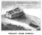
The Dipping Stone / Marriott, William. Antiquities of Lyme and its Vicinity (1810), plate facing p. 2.


.jpg)