
Dipping Stone (Whaley Moor): Difference between revisions
From International Robin Hood Bibliography
m (→Background) |
mNo edit summary |
||
| Line 11: | Line 11: | ||
* --> | * --> | ||
== Maps == | == Maps == | ||
* | * [https://maps.nls.uk/view/102341038#zoom=5&lat=8014&lon=10916&layers=BT 6" O.S. map ''Cheshire'' XXIX (1881; surveyed 1870-71)] | ||
* [https://maps.nls.uk/geo/explore/#zoom=16&lat=53.3327&lon=-2.0103&layers=6&b=5 6" O.S. map ''Cheshire'' XXIX.NE (1899; rev. 1896)] (georeferenced). | |||
* [https://maps.nls.uk/view/101598637#zoom=4&lat=3782&lon=3589&layers=BT 6" O.S. map ''Cheshire'' XXIX.NE (1899; rev. 1896)] | |||
* [https://maps.nls.uk/view/101598634#zoom=4&lat=3914&lon=3840&layers=BT 6" O.S. map ''Cheshire'' XXIX.NE (1913; rev. 1907)] | |||
* [https://maps.nls.uk/view/102341283#zoom=5&lat=5035&lon=6780&layers=BT 6" O.S. map ''Derbyshire'' VIII (1924; rev. 1919-20)] | |||
* 25" O.S. map ''Cheshire'' XXIX.3 (''c.'' 1873; ''c.'' 1870). No Copy in NLS | |||
* [https://maps.nls.uk/view/114582757#zoom=4&lat=1625&lon=12813&layers=BT 25" O.S. map ''Cheshire'' XXIX.3 (1897; rev. 1896)] | |||
* [https://maps.nls.uk/view/114582760#zoom=4&lat=1733&lon=13396&layers=BT 25" O.S. map ''Cheshire'' XXIX.3 (1909; rev. 1907).] | |||
* [https://maps.nls.uk/geo/explore/#zoom=17&lat=53.3324&lon=-2.0084&layers=168&b=5 25" O.S. map ''Cheshire'' XXIX.3 (1897; rev. 1896)] (georeferenced)] | |||
<!--== Discussion == | <!--== Discussion == | ||
* --> | * --> | ||
Revision as of 03:11, 21 February 2019
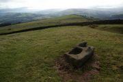
The Dipping Stone, Whaley Moor.
[[File:|thumb|right|500px|The Dipping Stone / Graham Hogg, 22 Sep. 2015, Creative Commons via Geograph.]]
By Henrik Thiil Nielsen, 2019-02-21. Revised by Henrik Thiil Nielsen, 2019-02-21.
_TEXT_ Template:PnItemQry
Gazetteers
- Not included in Dobson, R. B., ed.; Taylor, J., ed. Rymes of Robyn Hood: an Introduction to the English Outlaw (London, 1976), pp. 293-311.
Maps
- 6" O.S. map Cheshire XXIX (1881; surveyed 1870-71)
- 6" O.S. map Cheshire XXIX.NE (1899; rev. 1896) (georeferenced).
- 6" O.S. map Cheshire XXIX.NE (1899; rev. 1896)
- 6" O.S. map Cheshire XXIX.NE (1913; rev. 1907)
- 6" O.S. map Derbyshire VIII (1924; rev. 1919-20)
- 25" O.S. map Cheshire XXIX.3 (c. 1873; c. 1870). No Copy in NLS
- 25" O.S. map Cheshire XXIX.3 (1897; rev. 1896)
- 25" O.S. map Cheshire XXIX.3 (1909; rev. 1907).
- 25" O.S. map Cheshire XXIX.3 (1897; rev. 1896) (georeferenced)]
Background
- Historic England: Wayside and boundary cross known as The Dipping Stone
- Megalithic Portal: The Dipping Stone – Ancient Cross in England in Derbyshire.

The Dipping Stone / Graham Hogg, 22 Sep. 2015, Creative Commons via Geograph.
The Dipping Stone / Bill Boaden, 21 Feb. 2012, Creative Commons via Geograph.

The Dipping Stone / Chris Morgen, 22 Sep. 2015, Creative Commons via Geograph.
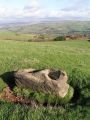
The Dipping Stone / Dave Dunford, 12 Nov. 2005, Creative Commons via Geograph.


