
Robin Hood Junction (Forest of Dean)
| Locality | |
|---|---|
| Coordinate | 51.804184, -2.637713 |
| Adm. div. | Gloucestershire |
| Vicinity | Junction of the A4136 and B4228, c. 1.2 km NW of Coleford |
| Type | Thoroughfare |
| Interest | Robin Hood name |
| Status | Extant |
| First Record | |

By Henrik Thiil Nielsen, 2018-10-16. Revised by Henrik Thiil Nielsen, 2021-02-13.
The junction of the A4136 and B4228 in the Forest of Dean, north of Coleford, is known as the Robin Hood Junction.
The junction is mentioned several times in a 2017 neighbourhood development plan.[1] The earliest online source revealed by a somewhat cursory search is a news item in a local newspaper from 2010.[2] An entry on the website of the Society for All British and Irish Road Enthusiasts notes that
The junction was originally a sharp fork slightly to the north west of its current location but was re-modeled in the 1990s to the layout we see today. The original junction can be clearly seen on satellite images and on the B4228 approaching the A4136 as a gap in the trees. Part time traffic lights control the junction.
It is not known to IRHB how long the junction has been named after the outlaw. However, there can be little doubt that the name was inspired by that of the Robin Hood Mine Pit, an abandoned mine in the immediate vicinity last worked during WWII.
Gazetteers
- Not included in Dobson, R. B., ed.; Taylor, J., ed. Rymes of Robyn Hood: an Introduction to the English Outlaw (London, 1976), pp. 315-19.
Sources
- Abbs, Beverley. 'Puzzlewood, Coleford, Forest of Dean', Malvern Gazette (2010-06-07), p. ?
- Forest of Dean District Council. Coleford Neighbourhood Development Plan: Appendices. A1: Town Centre and Conservation Area ([Coleford], 2017), pp. 79, 81, 93, 94, 95
- Society for All British and Irish Road Enthusiasts: Robin Hood Junction (Forest of Dean).
Maps
- 25" O.S. map Monmouthshire XV.2 (c. 1882; surveyed 1880). (No copy in NLS)
- 25" O.S. map Gloucestershire XXX.15 (1895; surveyed 1879-80)
- 25" O.S. map Gloucestershire XXX.15 (1902; rev. 1900)
- 25" O.S. map Monmouthshire XV.2 (1902; rev. 1900) (georeferenced)
- 25" O.S. map Monmouthshire XV.2 (1902; rev. 1900)
- 25" O.S. map Gloucestershire XXX.15 (1922; rev. 1920)
- 6" O.S. map Gloucestershire XXX.SE (1884; surveyed 1878-80)
- 6" O.S. map Gloucestershire XXX.SE (1903; rev. 1900) (georeferenced)
- 6" O.S. map Gloucestershire XXX.SE (1903; rev. 1900)
- 6" O.S. map Monmouthshire XV.NW (1903; rev. 1900)
- 6" O.S. map Monmouthshire XV (1924; rev. 1918)
- 6" O.S. map Gloucestershire XXX (1924; rev. 1920-21).
Also see
Notes
Image gallery
Click any image to display it in the lightbox, where you can navigate between images by clicking in the right or left side of the current image.
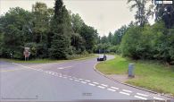
Looking roughly south at the Robin Hood Junction, Forest of Dean / Google Earth Street View.
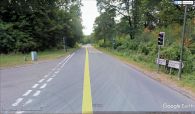
Looking northwest at the Robin Hood Junction, Forest of Dean / Google Earth Street View.
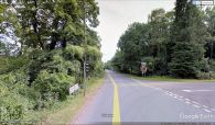
Looking southeast at the Robin Hood Junction, Forest of Dean / Google Earth Street View.

