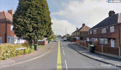
Robin Hood Drive (Hucknall)
From International Robin Hood Bibliography
| Locality | |
|---|---|
| Coordinate | 53.026895, -1.225117 |
| Adm. div. | Nottinghamshire |
| Vicinity | Connecting Willow Avenue and Roughs Drive in Westville |
| Type | Thoroughfare |
| Interest | Robin Hood name |
| Status | Extant |
| First Record | |
Robin Hood Drive, Westville, Hucknall.
By Henrik Thiil Nielsen, 2018-05-06. Revised by Henrik Thiil Nielsen, 2021-01-07.
Robin Hood Drive is a residential street connecting Willow Avenue and Roughs Drive in Westville, Hucknall. Not being included on the late 19th to mid-20th century O.S. maps listed below, it was presumably constructed in the latter half of the 20th century.
Gazetteers
- Not included in Dobson, R. B., ed.; Taylor, J., ed. Rymes of Robyn Hood: an Introduction to the English Outlaw (London, 1976), pp. 293-311.
Maps
- 25" O.S. map Nottinghamshire XXXII.16 (1880; surveyed 1879)
- 25" O.S. map Nottinghamshire XXXII.16 (1880; surveyed 1879) (georeferenced)
- 25" O.S. map Nottinghamshire XXXII.16 (1900; rev. 1899)
- 25" O.S. map Nottinghamshire XXXII.16 (1915; rev. 1913-14)
- 6" O.S. map Nottinghamshire XXXII.SE (1886; Surveyed 1878-79)
- 6" O.S. map Nottinghamshire XXXII.SE (1901; rev. 1899) (georeferenced)
- 6" O.S. map Nottinghamshire XXXII.SE (1901; rev. 1899)
- 6" O.S. map Nottinghamshire XXXII.SE (1919; rev. 1913-14)
- 6" O.S. map Derbyshire XLI (1921; rev. 1913-14)
- 6" O.S. map Nottinghamshire XXXII.SE (1921; rev. 1913-14)
- 6" O.S. map Nottinghamshire XXXII.SE (c. 1949; rev. 1938).

