
Robin Hood (Hampsfield)
| Locality | |
|---|---|
| Coordinate | 54.215438, -2.923845 |
| Adm. div. | Lancashire |
| Vicinity | Immediately E of Heaning Wood; Hampsfield Allotment, c. 1.3 km SE of Field Broughton |
| Type | Natural feature |
| Interest | Robin Hood name |
| Status | Defunct |
| First Record | 1851 |

By Henrik Thiil Nielsen, 2019-02-15. Revised by Henrik Thiil Nielsen, 2021-01-07.
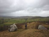
Two large stones of mountain limestone on Hampsfield Allotment, immediately east of Heaning Wood, c. 1.3 km SE of Field Broughton, used to be known as 'Robin Hood and Little John'. Though their collective name seems to have gone out of use, the two large stones still exist.
The earliest record of Robin Hood and Little John known to IRHB is a 6" O.S. map published in 1851, based on a survey carried out in 1848. The name is included in 6" and 25" O.S. maps published as late as c. 1947 and possibly later. James Stockdale noted in 1872 (see Allusions below) that they had "from time immemorial gone by the names of Robin Hood and Little John", but "[n]o reasons for these names are known". He suggested that they might have served as boundary marks for shepherds when the area was unenclosed. A recent arcaheological survey lists the stones as "possibly boundary markers of Medieval date", noting that they display "natural erosion features which are now upside down".[1] Two wandereres who photographed the stones in 2015 noted that "[r]ecent clearing has really opened up the area - a few years ago this was almost a woodland path hemmed in by trees and scrub".[2]
The district is now part of Cumbria.[3]
Allusions
1872 - Stockdale, James - Annales Carmoelenses
On the brow of the allotment above Haening Wood two large stones, of the mountain limestone in situ, stand out prominently on the surface. These have from time immemorial gone by the names of Robin Hood and Little John. They are so given in the six-inch [p. 475:] scale ordnance map. No reasons for these names are known, but the stones may have been local marks for the shepherds in the old times when the district was unenclosed.[4]
Gazetteers
- Not included in Dobson, R. B., ed.; Taylor, J., ed. Rymes of Robyn Hood: an Introduction to the English Outlaw (London, 1976), pp. 293-11.
Maps
- 25" O.S. map Lancashire XII.16 (1890; surveyed 1889)
- 25" O.S. map Lancashire XII.16 (1913; rev. 1911) (georeferenced)
- 25" O.S. map Lancashire XII.16 (1913; rev. 1911)
- 6" O.S. map Lancashire XII (1851; surveyed 1848)
- 6" O.S. map Lancashire XII.SE (1919; rev. 1911)
- 6" O.S. map Lancashire XII.SE (1919; rev. 1911) (georeferenced)
- 6" O.S. map Lancashire XII.SE (c. 1947; rev. 1911).
Discussion
Brief mention
Also see
Notes
- ↑ Morecambe Bay Partnership; [Martin, Louise]; [Peters, Cat]; [Newman, Richard]. The Archaeology of Hampsfell and Kirkhead: Archaeological Desk-Based Assessment and Volunteer Research (Carlisle, [2018]), p. 65, asset No. 63.
- ↑ SD3980 : Heading north on Hampsfield Allotment (2) by Karl and Ali.
- ↑ Old Cumbria Gazetteer: Robin Hood and Little John.
- ↑ Stockdale, James. Annales Carmoelenses: or Annals of Cartmel (Ulverston; London, 1872), pp. 474-75.
Image gallery
Click any image to display it in the lightbox, where you can navigate between images by clicking in the right or left side of the current image.
Robin Hood and Little John, Hampsfield / Karl and Ali, 1 Mar. 2015, Creative Commons, via Geograph.
