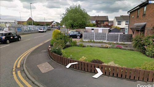
Robin Hood (Bradley Fold)
| Locality | |
|---|---|
| Coordinate | 53.5733, -2.3669 |
| Adm. div. | Lancashire |
| Vicinity | At or near 86 Bradley Lane, Bradley Fold; c. 14 km NNW of central Manchester |
| Type | Public house |
| Interest | Robin Hood name |
| Status | Defunct |
| First Record | 1839 |
| A.k.a. | Robin Hood Beer House |
By Henrik Thiil Nielsen, 2020-10-03. Revised by Henrik Thiil Nielsen, 2022-04-22.
A beer house named the Robin Hood on Bradley Lane in Bradley Fold, about 14 km NNW of central Manchester, is recorded in the tithe award for Ainsworth, drawn up in 1839. The hamlet of Bradley Fold is now a small district within the Metropolitan Borough of Bury, in Greater Manchester.
In 1839, the owner of the plot was the Earl of Wilton,[1] i.e. Thomas Egerton, 2nd Earl of Wilton.[2] The occupier was a David Yates.[3] 'Name and Description of Lands and Premises' are cited as 'Robin Hood Beer House and Garden'. When filling in the (generally) pre-printed form, the tithe commissioners usually found it expedient to proceed as though the column heading read 'Name OR Description of Lands and Premises', though we here get a bit of both. They also nearly always capitalized the initials of all nouns, which here gives the impression that the name of the etablishment was 'Robin Hood Beer House and Garden'. It was no doubt simply a beer house named the Robin Hood which had a garden. No state of cultivation is listed for the plot of land, but its area is cited as 10 perches (252.93 m2). At the time, the spot where the pub was situated was known as Spa Green (as in the early O.S. maps listed below). The tithe schedule has the incorrect reading 'Shaw Green', while "Spaw Green" in the tithe map is better.[4] The O.S. maps have a Spa Well at Spa Green, so this may have been a place that attracted visitors from the local area, and the well may of course have provided water for brewing. The pub is not indicated or named in the O.S. maps listed below.
Gazetteers
- Not included in Dobson, R. B., ed.; Taylor, J., ed. Rymes of Robyn Hood: an Introduction to the English Outlaw (London, 1976), pp. 293-311.
MS sources
- 1839 tithe award for Ainsworth, online at the Genealogist.com, Piece 18, sub-piece 004, Image 021, #504 (£)
- accompanying map, online at the Genealogist.com, Piece 18, sub-piece 004, Sub-Image 001, #504 (£).
Maps
- 25" O.S: map Lancashire LXXXVII.15 (c. 1893; surveyed c. 1889-90). No copy in NLS
- 25" O.S. map Lancashire LXXXVII.15 (1910; rev. 1908)
- 25" O.S. map Lancashire LXXXVII.15 (1930; rev. 1927)
- 25" O.S. map Lancashire LXXXVII.15 (1938; rev. 1937)
- 25" O.S. map Lancashire LXXXVII.15 (1910; rev. 1908) (georeferenced)
- 6" O.S. map Lancashire LXXXVII.SE (1911; rev. 1908) (georeferenced)
- 6" O.S. map Lancashire LXXXVII (1850; surveyed 1844–47)
- 6" O.S. map Lancashire LXXXVII.SE (1894; surveyed 1889–90)
- 6" O.S. map Lancashire LXXXVII.SE (1911; rev. 1908)
- 6" O.S. map Lancashire LXXXVII.SE (1931; rev. 1927)
- 6" O.S. map Lancashire LXXXVII.SE (1947; rev. 1938–39).
Background
- MS tithe award for the township of Atherton in the Parish of Leigh, at The Genealogist: piece 18, sub-Piece 023, Image 020, #775, #777
- Wikipedia: Bradley Fold
- Wikipedia: Earl of Wilton
- Wikipedia: Thomas Egerton, 2nd Earl of Wilton.
Also see
Notes
- ↑ 1839 tithe award for Ainsworth, online at the Genealogist.com, Piece 18, sub-piece 004, Image 021, #504 (£); accompanying map, online at the Genealogist.com, Piece 18, sub-piece 004, Sub-Image 001, #504 (£).
- ↑ Wikipedia: Thomas Egerton, 2nd Earl of Wilton.
- ↑ As of 3 Oct. 2020, his name is incorrectly transcribed as Davis Yates at the Genealogist.
- ↑ Evidently a Lancashire form. See Tithe award for the township of Atherton in the Parish of Leigh, at The Genealogist: piece 18, sub-Piece 023, Image 020, #775: Spaw Head, and #777: 'Meadow under Spaw'.

