
Little Barnsdale (Oswaldkirk)
| Locality | |
|---|---|
| Coordinate | 54.199221, -1.068438 |
| Adm. div. | North Riding of Yorkshire |
| Vicinity | c. 335 m S of Oswaldkirk Bank (B1363), c. 600 SE of the intersection of that road and Aumit Lane |
| Type | Area |
| Interest | Literary locale |
| Status | Defunct? |
| First Record | 1838 |

By Henrik Thiil Nielsen, 2020-09-03. Revised by Henrik Thiil Nielsen, 2022-04-22.
A field in Oswaldkirk in the North Riding of Yorkshire (now North Yorkshire) was known as Little Barnsdale in 1838.
The field is listed in the tithe award for Oswaldkirk with Edward Oakley Banner, Esq., as owner, William Bland as occupier, 'Grass' as state of cultivation, and an area of 3 roods and 37 perches (3970.98 m2).[1] While the field name may have arisen independently, it may also have been transferred from that of Barnsdale (Doncaster) or Barnsdale (Exton), or just possible that of Barnsdale (Great Easton) or Eagle Barnsdale. Only in case it was named after the area north of Doncaster is there a likely connection with the Robin Hood tradition. The other Barnsdales have no connection with the outlaw.
Gazetteers
- Not included in Dobson, R. B., ed.; Taylor, J., ed. Rymes of Robyn Hood: an Introduction to the English Outlaw (London, 1976), pp. 293-311.
MS sources
- 1838 tithe award for the parish of Oswaldkirk, online at the Genealogist.com, Piece 42, sub-piece 290, Image 069, #124 (£)
- accompanying map, online at the Genealogist.com, Piece 42, sub-piece 290, Sub-Image 001, color (£).
Maps
- 25" O.S. map Yorkshire CV.7 (1892; surveyed 1889)
- 25" O.S. map Yorkshire CV.7 (1911; rev. 1910) (georeferenced)
- 25" O.S. map Yorkshire CV.7 (1911; rev. 1910)
- 6" O.S. map Yorkshire 105 (1856; surveyed 1854)
- 6" O.S. map Yorkshire CV.NE (1895; surveyed 1889–91)
- 6" O.S. map Yorkshire CV.NE (1913; rev. 1910) (georeferenced)
- 6" O.S. map Yorkshire CV.NE (1913; rev. 1910)
- 6" O.S. map Yorkshire CV.NE (1952; rev. 1950).
Background
Also see
Notes
- ↑ 1838 tithe award for the parish of Oswaldkirk, online at the Genealogist.com, Piece 42, sub-piece 290, Image 069, #124 (£); accompanying map, online at the Genealogist.com, Piece 42, sub-piece 290, Sub-Image 001, colour (£).
Image gallery
Click any image to display it in the lightbox, where you can navigate between images by clicking in the right or left side of the current image.
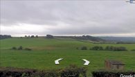
Little Barnsdale was part of the green area in front of the far hedge, center / Google Earth Street View.

Little Barnsdale is indicated in gray / Detail of 25" O.S. map Yorkshire CV.7 (1892; surveyed 1889); reprod. with perm. of NLS; under Creative Commons Attrib. (CC-BY) license; adapt. Henrik Thiil Nielsen.
